Capacity Building Infrastructure on North Eastern India
290 likes | 313 Vues
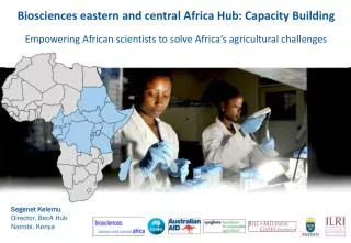
Enhancing capacity building in North Eastern India through a range of programs and courses on space technology and applications. Collaborations with institutions and outreach to decision makers and forestry officials.

Capacity Building Infrastructure on North Eastern India
E N D
Presentation Transcript
Capacity Building Infrastructure on North Eastern India Committee on Earth Observation Satellites • PLNRaju, Director • North Eastern Space Applications Centre (NESAC) • CEOS WGCapD-8 Annual Meeting • Working Group on • Capacity Building & Data Democracy • Indian Institute of Remote Sensing • Indian Space Research Organisation • Dehradun, India • March 06th – 08th, 2019
Capacity Building Infrastructure on North Eastern India • NER at a Glance Socio-economic development in the region governed by MDoNER’s (Ministry for Development of North Eastern Region) and North Eastern Council (NEC).
Major End-Users of NESAC: Towards Utilizations of Space Tech inputs
Short term courses – 522 participants • Academic interactions – 155 participants & 21 Institutions • MoU - NEHU, USTM, DU, DBU, NIT-M, MIT (AU), IISc etc. • Collaborations - ICAR, NEIST, NU, NEC, MDONER, AAU, CSB etc. • Academic Linkages: Research Collaborations (major achievements) 5-9 March, 2019 Shri R.R. Okhandiar, IFS, Member Secretary, CSB, Bengaluru giving his opening remarks during inauguration function 22-23 Oct, 2018 Brainstorming Workshop on Space Science & Technology and its Applications was organized at Dibrugarh University, Assam on 9 Nov, 2018
Outreach: Utilization of Space Tech. Applications for Decision makers Two days training for Asst. tech. Managers of MAMETI 7-8 Feb, 2019 Outreach for Forestry Officials, Arunachal Pradesh, 12-16 Nov, 2018
Outreach: Utilization of Space Tech. Applications Course Conducted • Short Term Courses: 77 candidates - Basic Courses on RS&GIS – 47 candidates - UAV Remote Sensing – 30 candidates • Project specific training: 100 officials - AMRUT Capacity Building – 100 officials • Region specific Workshop : 282 participants - Training for collection of Data on border villages for Meghalaya - 5 - Application of modern tools and technologies for state forest service officers, Byrnihat Meghalaya– 29 - Development of CRM Tools in Agriculture and water resources management – 25 - State Meet on promoting Space Technology - 223 • State Meets Conducted: - Arunachal Pradesh - Assam - Manipur - Meghalaya - Mizoram - Nagaland
Proposed Programme*** • Regular Thematic courses (1 WK) • Water Resources • Geosciences • Disaster management • Atmospheric Science • Agriculture • Forestry • UAV RS • Tailor made course • (as per demand) • Courses for BIMSTEC countries • Three Weeks res. Courses (2) • 2 Weeks Short term Courses (2) • Expanding Outreach: Existing & Proposed Programme • Existing Outreach activities • Regular Certificate courses • 2 weeks Basic course (Once in every yr) • 2 weeks Adv. course (Once in every yr) • Tailor made course • 1-2 weeks for Govt. Depts • 1-2 weeks for Educational Inst. • Encouraging students • Students internships • Students visits ***Existing Outreach programme will continue
Potential Organizations: Associated with Outreach & Research activities
Student enrolment statistics Coverage From various places Details of dissertation students/summer trainees: 2018 2017-2019
Students Enrolment : During 2019 from various Educational Institutions
Hon'ble Prime Minister of India declared that the Government of India will provide outreach and capacity building programme to the researchers, students and professors of BIMSTEC countries on Space Technology Tools and Applications at NESAC. 4th Summit of BIMSTEC, Kathmandu, Nepal, 30-31 August, 2018 • Capacity building for BIMSTEC countries Bay of Bengal Initiative for Multi Sectoral Technical and Economic Cooperation • Three Month Residential Certification Course: 12 Research Personnel from BIMSTEC countries (2 candidates from each country) will attend the course. Stipend will be provided to the candidates in addition to their other travel/boarding expenses etc. • Short Term Residential Course: This course is planned for 12 Research Personnel from BIMSTEC countries (2 candidates from each country) on the Fundamentals of Remote Sensing and GIS. The entire expenses including travel/boarding etc. will be taken care. • Two such courses are planned every year for 24 persons • Two such courses are planned every year for 24 persons
Facilities • High speed campus 1G Wifi • Smart class room (2) • Sophisticated lab (2) • Outreach Cloud facility for student • 100 seater conference room • Dedicated VC/conference • Library facility • Hostel (80 seater) • Fitness centre • New Outreach Facility at NESAC: Infrastructures
Outreach entrance Hostel Facility • New Outreach Facility at NESAC: Infrastructures Conference hall VC Hall
Hostel accommodation Smart classroom • New Outreach Facility at NESAC: Infrastructures Multi gym Recreation room
Solar panels Water treatment plant • New Outreach Facility at NESAC: Infrastructures Mess Solar water heater
FOREST WORKING PLAN Working Plan coverage in NER Approved Working Plan for Garo Hills Forest Division Land Resources & Forest type map • Success Story • Forest Working Plan for Meghalaya and Mizoram have been approved Working Plan for Lunglei Forest Division
DEVELOPMENT OF SERICULTURE • Mapping of potential areas for silkworm food plants and Updation of SILKS portal (Phase II) • Potential area mapping: Mulberry, Muga, Eri and Tasar • 70 priority districts from 25 States. • SILKS portal upgraded and is available in 12 languages • Mulberry acreage and leaf protein estimation • Area: Four districts of West Bengal • Technique: Hyperspectral study of leaf protein • Development of MIS: Decision making tool at farmers level and integrated with SILKS • Early warning of Muga Silkworm diseases and pests • Identification of landscape and climatic parameters crucial for disease incidence • Development of decision support system for diseases in progress • Geo-tagging of assets created under CSB funded projects • Monitoring of Sericulture assets created under CSB funded project/ schemes in the country with GAGAN LULC of Muga farm taking 5km Buffer
CHAMAN Project • Objectives • Identification and mapping of suitable areas for important horticultural crops in NER • One selected crop for 8 selected districts of NE states. • Study areas • One selected crop for 8 selected districts of NE states. • Current status • Completed the site suitability analysis of the selected crops in 8 selected districts of NE states. • Report submitted to MNCFC, New Delhi with detail maps and area statistics. • Future plan • In the second phase, one more crop will be selected from 8 districts of NE states for site suitability analysis. • NORTH EASTERN SPACE APPLICATIONS CENTRE
FLOOD EARLY WARNING SYSTEM (FLEWS) for NER The Assam operational exercise Flood models developed for other NER states Mean Seasonal alert success score (2012-2018) Manipur (2 models) Meghalaya (8 models) Arunachal (7 models) Nagaland (3 models) Nematighat Discharge based hydro-dynamic flood inundation simulation (under NHP) by NESAC hydro team DWLR installed at two rivers (Beki & Aei) under FLEWS, Assam Tezpur Sikkim (1 model) Tripura (5 models) • Highlights & Issues: • FLEWS, Assam has completed 7 years as an operational exercise from 2012 to 2018. An average yearly alert success score of 75% with lead time ranging from 12- 36 hrs • Presently focus is on for extension of the service to other NER states. • Unlike Assam, hydro-met observations in other NER states is inadequate leading to difficulty in calibration and validation of the flood forecasting models. No funding support available at present for extension of FLEWS services to the other NER states Total of 28 models have been built and made ready for calibration and validation as part of extension of FLEWS to other NE states Mizoram (2 models)
RIVER ATLAS FOR ASSAM • Achievements (Phase I): • Map all major and minor rivers of Assam (1:4,000) within state with emphasis on flood & erosion protection as well as flow regulation structures. • Map the source of origin of all the major rivers and tributaries • To delineate river catchments at different hierarchy • To map the structural measures for flood and erosion management • Prepare LULC map at 1:10K scale along the river banks with defined buffer • Discharge and sediment transport related model studies (Phase II) Detailed district map showing all the major and minor rivers Catchment map showing the source of origin of all rivers entering the district Interim review & Map release by Hon’ble CM, Assam LULC map for all the rivers with defined buffer • An interactive high resolution information system for river channels (Upto Sub-tributaries) in Brahmaputra & Barak valley of Assam • First of it kind baseline database for planning & execution of interventions for flood & bank erosion management
District Resources Plan in NE region Receipt of National e-Governance Award 2017-18
GeoTagging & GeoMonitoring of Government Schemes/Projects • GeoTagging of • 1500+ NEC funded projects • 4000+ BTC Schemes • Agro-Horti assets /Sericulture assets • Infra. under AMRUT project • GeoTagging/Monitoring via • Mobile App with GAGAN/SBAS • Satellite/Drone images/Videos • Distributed 500 GAGAN dongles to planning departments of state for geo-tagging NLCPR assets. • Monitoring Dashboard • Near-realtime monitoring tools/MyDoNER App • GeoVisualization of schemes Monitoring via high resolution satellite imagery Monitoring of Orchid Lake resort construction ONTIME UC MAX. UTILIZATION OF RESOURCES ENHANCHED GAP ANALYSIS ACCURATE PLANNING TRANSPERANCY IN MONITORING 25.07.2018 25.07.2018 25.07.2018
There are more than 100 Overall Institutions offering EO and Geo-information in India • In North East there are 15 Government / Central universities and 30 no of private universities but very few offer EO and Geo-informatics education and training. • Limited awareness and short term programs are offered at different Centres in NE. • Seminars / Conferences / Workshops are offered in Remote Sensing and Geoinformatics are organized as part professional Societies i.e. ISRS/ISG/INCA/ISPRS/IMS etc. • List of Institutions offering courses EO courses in North East
NESAC established Outreach and Capacity Building infrastructure facility and plan to offer short and long duration programs in EO and Geo-information. • Recognizing well established state of art infrastructure and proximity to BIMSTEC Countries, honorable PM of India announced short courses (2 weeks) and Certificate Courses (3 months) at NESAC, funded by MEA, GOI • It is possible to conduct three parallel programs simultaneously with a capacity of 40 to 50 participants. • Three state of art IT & Geo-informatics laboratory facility for the participants for hands on and practical meeting the short and long term training programs • Theme based training short term training programs (i.e. AS/WR/FE/UR/AS etc.) are planned to be conducted. • Capacity Building Infrastructure Development in North East India
Basic training programs in RS & GIS on regular basis • Advanced training programs in HSRS/MWRS/UAV RS / ML/AI/DL etc. etc. • Tailor – made programs in Agriculture / Forest/ Urban Planning etc. • Planning training programs specific to eight states of NE jointly with IIRS/NRSC/SAC under NNRMS • Short / long term research / operational project support programs for graduate / post-graduate students / researchers / academic institutions at the newly established outreach facility • Visits to NESAC are organized to large number of Students / Academicians / Researchers from allover India, majority from North East of India. • Capacity Building Infrastructure Development in North East India
NESAC can take up any initiatives of WGCapD-8 in the area of Remote Sensing, geo-information, UAV RS, Space Science, Meteorology, satellite communication and their applications for the eastern part of India as well as neighboring countries being proximity to this region Thank you all for the opportunity • NESAC offer to WGCapD-8