Landslides
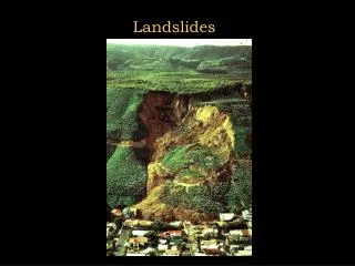
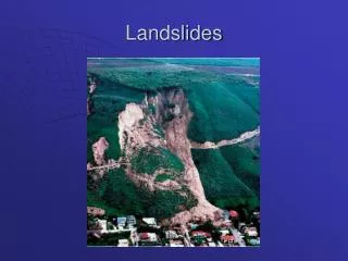
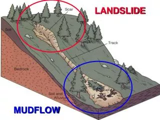
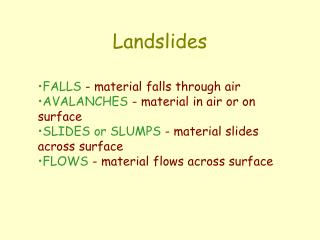
Landslides. FALLS - material falls through air AVALANCHES - material in air or on surface SLIDES or SLUMPS - material slides across surface FLOWS - material flows across surface. Landslide and avalanche hazards. Thousands of people killed annually world-wide

Landslides
E N D
Presentation Transcript
Landslides • FALLS - material falls through air • AVALANCHES - material in air or on surface • SLIDES or SLUMPS - material slides across surface • FLOWS - material flows across surface
Landslide and avalanche hazards • Thousands of people killed annually world-wide • Annual property damage ~$1.5 billion in USA, probably tens of billions world-wide • Small to medium-sized events responsible for most of the property damage
Examples of landslide disasters 1970 - Yungay, Peru A minor earthquake loosened a small mass of glacial ice and rock on the flanks of Mt. Huascaran in the Peruvian Andes. It fell ~650 m and landed on a mass of unconsolidated rock. The resultant debris avalanche cascaded downvalley for a distance of 65 km, reaching speeds of >400 km/h. Some 25,000 to 45,000 people died in the town of Yungay and neighbouring villages.
Examples of landslide disasters 1903 - Frank, AlbertaA rock avalanche (30 M m3) slid off the eastern face of Turtle Mountain, covering 3 km in about 100 seconds. The avalanche buried the outskirts of the mining town of Frank. Some 75 people died. Monitored since 1933.
Canada: landslide fatalities by province (1840 - present) Frank slide
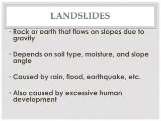
Falls, slides, slumps and flows • Slope angle - the steeper the gradient, the more likely it is to fail • Substrate - unconsolidated sediments and fractured rocks more prone to failure than massive or well-cemented rocks • Water - the more saturated the material, the more likely it is to fail
Rockfall hazards in montane areas Wadi Al-Ayn, Hadramawt Valley, Yemen Rockfall; Al-Dhafir, Yemen: ~50 people killed (December, 2005)
Rockfalls: BC Fraser Canyon This rockfall near Furry Creek in July 2008 covered 75 metres of the Sea to Sky Highway in rubble 10 metres deep and also took out the railway line below the highway. The highwaywas closed for 3 days. The slope was stabilized by blasting. Photos: Natural Resources Canada and Canadian Press
Canada’s largest rock avalanche in the historic period (January, 1965) 46 million cubic meters of rock debris avalanched down a the side of a mountain in SW BC in January 1965 forming a fan up to 80 m thick and 3 km wide, Four people driving on the Hope-Princeton Highway were killed. There is no known triggering event for this slide. Photos: Natural Resources Canada
Rock/debris avalanches - Rubble Creek • Site of two large debris avalanches and several debris flow during the Holocene. • Source of the landslides is The Barrier, which is a precipitous rock face formed by a 300 m thick lava flow which abutted against a glacier occupying Cheakamus valley in the late glacial. Much of the landslide debris from this cliff has formed a fan at the mouth of Rubble Creek. • The fan consists of 5 - 10 landslide units, each 5 - 10 m in thickness. Total volume ~ 170 million cubic metres. • Most recent failure occurred in 1855-56. That avalanche (~ 30 million cubic metres) traveled 6 km down Rubble Creek at a speed of 60 m/s in the upper part of the path, and 25-40 m/s down-valley.
rain load Frictional strength keeps material on slope cut/ erode quake Slumps, slides, etc.factors reducing slope strength log
Earthquake-induced landslides This shallow debris slide near Tacoma (WA) was initiated by the Olympia earthquake of 1949. The failure occurred several days after the earthquake. The landslide generated a small tsunami in the Narrows.
Location of slides in southern Puget Sound, December 24-26, 1996
Debris slides in unconsolidated glacial and fluvio-glacial deposits,Puget Sound(Dec 1996)Triggered by record rainfalls in one week
Surficial geology:Seattle area (or earthquake liquefaction) “piping” ? permeable impermeable
Escarpments and landslide risk areas in the GVRD Source: Eisbacher and Clague, 1980
Landslide videos Slump after heavy rains (Japan) http://www.youtube.com/watch?v=pJF-RhL4TvE La Conchita earthflow http://www.youtube.com/watch?v=W4KWxglDL3o
Flowslides= rapid earthflows(e.g. in leda clays)Québec, Norway
Landslides in glaciomarine clays of the Champlain Sea Extent of the Champlain Sea (black dots = whale fossils in GM deposits) Slides predominantly along river banks
FlowslideSt.-Jean-Vianney, Qué., 1971(31 deaths, 40 houses destroyed)
Aerial photo of flowslide, Nicolet, Québec (1955)The church (circled) was later demolished
Debris flows, Typhoon Durian, Philippines (Dec. 2006) Heavy rain from Typhoon Durian unleashed mudslides from the flanks of Mt. Mayon in the Phillipines, which had been active in July-August (top right). Photos: BBC News
Hurricane Stan (and other storms) dumped upwards of 500 mm of rain in southern Mexico - El Salvador in a 6-day period in October 2005. Debris flows and mudslides occurred in the highlands and floods in the valleys. • >1500 people died in Guatemala. Most of the deaths occurred in the small town of Panabaj, which was engulfed in a mudslide up to 12m thick. As in the Phillipines, the mudslides were derived from recent volcanic deposits.
3 2 1 1 2 3 Debris flows, northern Venezuelain Dec. 1999 (30 000 deaths) Debris flow scars on hillsides Sediment deposition on alluvial fans Suspended sediment offshore Triggered by 1200 mm of rainfall in one month, including 500 mm in two days
Settlements in canyons and on alluvial fans along narrow coastal strip Caraballeda Note debris flow scars and deposits in valleys Note size of boulders and height of debris flow damage
Debris flow in North Vancouver, Dec. 2005 • 1 death • North Van. District purchased properties at risk; installed piezometers to monitor water-table fluctuations.
Cheekye Fan • Site of many large debris avalanches and several moderate to large debris flows during the Holocene. • Source of the landslides is the west flank of the volcanic cone of Mt. Garibaldi, which may have been partly built on top of valley ice in the late glacial. This flank is therefore subject to collapse. Much of the landslide debris from this cliff has formed a fan at the mouth of the Cheekye River. • The fan consists of many landslide units, only some of which have been adequately dated. Total volume ~ 2.5 - 3 billion cubic metres. • Debris flows have continued in historic times. In 1958 a debris flow swept down the Cheekye River and formed a 5 m dam across the Cheakamus at its mouth. A similar event occurred in the 1930’s. Flow volumes were ~100 000 cubic metres.
Stump Lake cores From: Clague et al., 2003. Environmental and Engineering Geoscience 9, 99-115.
Landslide dams • Large landslides may form temporary dams across valleys; e.g. oral traditions describe Native Americans crossing the Columbia River on the “Bridge of the Gods” slide complex (product of AD1700 megaearthquake?) • Landslide dams may fail catastrophically
Landslides, Sichuan earthquake: May 2008 after (2008) before (2006) Images: NASA Earth Observatory
Lake formed by landslide dam, Sichuan, May 2008 At least 20 lakes were formed behind seismically-triggered landslide dams in the area affected by the Sichuan earthquake. The inhabitants of towns downstream of the dams (e.g. Beichuan) were evacuated because of the risk of debris flows and floods if the dams failed catastrophically. Images: NASA Earth Observatory
Landslide dam failures The Río Barrancas, in northwestern Argentina, was dammed in prehistoric time by a large landslide, forming a 21-km-long lake. In 1914, the Río Barrancas breached this dam; overnight the lake surface was lowered about 95 m. The resultant debris flow/flood had an estimated volume of 2 billion m3. No data are available on casualties or damage costs downstream, but cattle ranches and farms along the 60-km canyon and valley of the Río Barrancas completely disappeared. In addition, two small towns in the valley were devastated. landslide scar lake outlet Sketch of Lago Cari Lauquen on the Río Barrancas, Argentina after the dam was breached(Groeber, 1916)
Preventive measures: rockfalls • Rock bolts (tie loose rocks to stable base) • Shotcrete (debris adheres to stable base) • Guard mesh (captures rockfall material) • Drainage pipes (relieve pore pressure in basal rocks) • Rockfall sheds (deflect material over highways, etc.)
Protection/mitigation:hybrid “hard-soft” landscaping solutions Source: Baumann Engineering (Laguna Beach CA, project) unplanted mesh + planting
Monitoring of high-risk landslidesE=extensiometersB= instrumentedboreholes Woodway landslides.usgs.gov/woodway/ (no longer continuously monitored)
Woodway Daily precipitation (green) and water table fluctuations Extensiometersmeasure creep downslope (units = cm) Equipment malfunctionat E-1
Prevention/mitigation(trench drainage of toe of active slide, Scotland)