Download
1 / 27
320 likes | 571 Vues
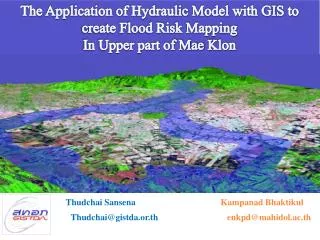
The Application of Hydraulic Model with GIS to create Flood Risk Mapping In Upper part of Mae Klon. Thudchai Sansena. Kampanad Bhaktikul. Thudchai@gistda.or.th. enkpd@mahidol.ac.th. The Application of Hyraulic Model with GIS to create Flood Risk Mapping in Upper part of Mae Klong.

E N D
The Application of Hydraulic Model with GIS to create Flood Risk Mapping In Upper part of Mae Klon Thudchai Sansena Kampanad Bhaktikul Thudchai@gistda.or.th enkpd@mahidol.ac.th
The Application of Hyraulic Model with GIS to create Flood Risk Mapping in Upper part of Mae Klong INWEPF 4th Steering Meeting and Symposium July 5, 2007 Bangkok Thailand Objectives The purpose of this study is: 1. To establish flood risk map by integration of hydraulic model with Geo –Informatics technique. 2. To develop the regional model for flood risk mapping and classification of degree of flood hazard in warning, prevention and management plans Geo-Informatics and Space Technology Development Agency (Public Organization) Geo-Informatics Office
The Application of Hyraulic Model with GIS to create Flood Risk Mapping in Upper part of Mae Klong INWEPF 4th Steering Meeting and Symposium July 5, 2007 Bangkok Thailand Study Area Chiang Mai Khon Kean Upper Part of Mae Klong River Estimate 70 km. Mae Klong Phuket -10 Geo-Informatics and Space Technology Development Agency (Public Organization) Geo-Informatics Office
The Application of Hyraulic Model with GIS to create Flood Risk Mapping in Upper part of Mae Klong INWEPF 4th Steering Meeting and Symposium July 5, 2007 Bangkok Thailand Methodology 2. Geo - Informatics Analysis 1. Hydrology Analysis 3.Hydraulic Model Calibration 4. Flood Risk Analysis Geo-Informatics and Space Technology Development Agency (Public Organization) Geo-Informatics Office
The Application of Hyraulic Model with GIS to create Flood Risk Mapping in Upper part of Mae Klong INWEPF 4th Steering Meeting and Symposium July 5, 2007 Bangkok Thailand Analysis and Design Hydrology • - Normal • 2-parameter Log normal • - 3-parameter Log normal • Pearson Type III • Log-Pearson Type III • Gumbel distributions 2-parameter Log normal Chi square test Geo-Informatics and Space Technology Development Agency (Public Organization) Geo-Informatics Office
5000 4500 4000 3500 3000 2500 2000 1500 1000 500 0 days 14 21 28 7 The Application of Hyraulic Model with GIS to create Flood Risk Mapping in Upper part of Mae Klong INWEPF 4th Steering Meeting and Symposium July 5, 2007 Bangkok Thailand Analysis and Design Hydrology Observed Hydrograph 25 year Design Hydrograph 50 year Design Hydrograph 100 year Design Hydrograph 200 year Design Hydrograph Dimensionless hydrograph * 2 Log normal distribution = Hydrology simulationdata Geo-Informatics and Space Technology Development Agency (Public Organization) Geo-Informatics Office
The Application of Hyraulic Model with GIS to create Flood Risk Mapping in Upper part of Mae Klong INWEPF 4th Steering Meeting and Symposium July 5, 2007 Bangkok Thailand Development of Geo Informatics Create Terrain Data Geometry Survey Contour point GIS DATA TIN PROCESS Terrain Model DEM DATA Geo-Informatics and Space Technology Development Agency (Public Organization) Geo-Informatics Office
The Application of Hyraulic Model with GIS to create Flood Risk Mapping in Upper part of Mae Klong INWEPF 4th Steering Meeting and Symposium July 5, 2007 Bangkok Thailand Development of Geo Informatics Interpret Remote Sensing Data Interpret Land use level2 Paddy field Field crop Orchard Perennial Forest Urban and village RS 1996 and 2006 Land use 1996 and 2006 Water body Open space Geo-Informatics and Space Technology Development Agency (Public Organization) Geo-Informatics Office
The Application of Hyraulic Model with GIS to create Flood Risk Mapping in Upper part of Mae Klong INWEPF 4th Steering Meeting and Symposium July 5, 2007 Bangkok Thailand Development of Geo Informatics Export Terrain Data Bank Sta=1188.85,1412.98 XS Rating Curve= 0 Exp/Cntr=.3,.1 Type RM Length L Ch R = 1 ,71338.45,166.63,1112.21,1073.77 XS GIS Cut Line=4 582145.8591540788.577580931.031540184.228 580789.4281540113.785580440.0481538852.934 Node Last Edited Time=21/02/25472:57:54 PM #Sta/Elev= 60 015.4134.5515.47185.6915.38317.3515.54385.9216 416.6716687.19161194.8516.641196.13171197.1517.06 1202.0517.011204.4516.771221.2516.221321.5517.481333.2617.73 1354.7716.911360.8813.291368.7510.211373.617.751378.834.23 1383.8341388.833.831393.833.81398.833.731403.833.9 1408.834.11413.833.851418.833.51423.833.41428.833.28 1433.832.981438.833.031443.832.951448.833.131453.834.1 1458.834.71463.834.981468.8351473.834.91478.835.4 1481.715.41501.399.041508.4711.721513.0815.75151516.18 1516.416.741524.3416.771526.0816.281542.3115.531801.4215.44 1819.7515.471858.6815.541912.0815.631947.915.691955.0615.7 1983.1615.752044.1615.832596.7415.782819.9915.92823.3715.9 #Mann= 3 , 0 , 0 0 .0401354.77 .03501513.08 .040 Extract Terrain Model By HEC-GeoRAS Terrain Model Geo-Informatics and Space Technology Development Agency (Public Organization) Geo-Informatics Office
The Application of Hyraulic Model with GIS to create Flood Risk Mapping in Upper part of Mae Klong INWEPF 4th Steering Meeting and Symposium July 5, 2007 Bangkok Thailand Development of Geo Informatics Geo-Informatics and Space Technology Development Agency (Public Organization) Geo-Informatics Office
meter 8 6 4 2 Terrain data 0 Survey data -2 -4 meter -6 3000 3500 4000 0 1000 1500 2000 2500 500 The Application of Hyraulic Model with GIS to create Flood Risk Mapping in Upper part of Mae Klong INWEPF 4th Steering Meeting and Symposium July 5, 2007 Bangkok Thailand Development of Geo Informatics Compare data between Terrain model with Geometry survey Geo-Informatics and Space Technology Development Agency (Public Organization) Geo-Informatics Office
The Application of Hyraulic Model with GIS to create Flood Risk Mapping in Upper part of Mae Klong INWEPF 4th Steering Meeting and Symposium July 5, 2007 Bangkok Thailand Model calibrationc Calibration step 1. Coarse scale: selected the Manning’s values between 0.02 – 0.05 and divided interval into 0.005 2. Delicate scale: the best interval values from rough scale divided interval into 0.001 for selecting the best n Manning’s values of this study Geo-Informatics and Space Technology Development Agency (Public Organization) Geo-Informatics Office
The Application of Hyraulic Model with GIS to create Flood Risk Mapping in Upper part of Mae Klong INWEPF 4th Steering Meeting and Symposium July 5, 2007 Bangkok Thailand Model calibrationc Manning’s values 0.026 was select for this study Geo-Informatics and Space Technology Development Agency (Public Organization) Geo-Informatics Office
The Application of Hyraulic Model with GIS to create Flood Risk Mapping in Upper part of Mae Klong INWEPF 4th Steering Meeting and Symposium July 5, 2007 Bangkok Thailand Model calibration Geo-Informatics and Space Technology Development Agency (Public Organization) Geo-Informatics Office
The Application of Hyraulic Model with GIS to create Flood Risk Mapping in Upper part of Mae Klong INWEPF 4th Steering Meeting and Symposium July 5, 2007 Bangkok Thailand Flood Risk Map 1. Import water level data and create water surface 2. Compute flood area 4. Create flood Risk area 3. Create flood hazard area Geo-Informatics and Space Technology Development Agency (Public Organization) Geo-Informatics Office
The Application of Hyraulic Model with GIS to create Flood Risk Mapping in Upper part of Mae Klong INWEPF 4th Steering Meeting and Symposium July 5, 2007 Bangkok Thailand Flood Risk Map Rule of flood area If water surface - terrain data > 0 then = flood area and value = water height Else not flood area Geo-Informatics and Space Technology Development Agency (Public Organization) Geo-Informatics Office
The Application of Hyraulic Model with GIS to create Flood Risk Mapping in Upper part of Mae Klong INWEPF 4th Steering Meeting and Symposium July 5, 2007 Bangkok Thailand Flood Risk Map Comparison between area Flood 1996 and area Flood simulation 1996 Overlappingarea Flood area 1996 non overlap Flood area from model non overlap Area flood simulation 1996 Geo-Informatics and Space Technology Development Agency (Public Organization) Geo-Informatics Office
The Application of Hyraulic Model with GIS to create Flood Risk Mapping in Upper part of Mae Klong INWEPF 4th Steering Meeting and Symposium July 5, 2007 Bangkok Thailand Geo-Informatics and Space Technology Development Agency (Public Organization) Geo-Informatics Office
The Application of Hyraulic Model with GIS to create Flood Risk Mapping in Upper part of Mae Klong INWEPF 4th Steering Meeting and Symposium July 5, 2007 Bangkok Thailand Flood Risk Map Flood Hazard can divide into 2 charaxteristics 1.1 water level heights ;represent into 1) 0 – 0.5 m, 2) 0.5 – 1 m 3) more than 1 m 1.2 flood duration time 1) 1 -3 day, 2) 4-10 day m 3) more than 10 day Geo-Informatics and Space Technology Development Agency (Public Organization) Geo-Informatics Office
The Application of Hyraulic Model with GIS to create Flood Risk Mapping in Upper part of Mae Klong INWEPF 4th Steering Meeting and Symposium July 5, 2007 Bangkok Thailand Flood Risk Map Flood Hazard define by water height Geo-Informatics and Space Technology Development Agency (Public Organization) Geo-Informatics Office
The Application of Hyraulic Model with GIS to create Flood Risk Mapping in Upper part of Mae Klong INWEPF 4th Steering Meeting and Symposium July 5, 2007 Bangkok Thailand Flood Risk Map Flood Hazard define by duration time Geo-Informatics and Space Technology Development Agency (Public Organization) Geo-Informatics Office
The Application of Hyraulic Model with GIS to create Flood Risk Mapping in Upper part of Mae Klong INWEPF 4th Steering Meeting and Symposium July 5, 2007 Bangkok Thailand Flood Risk Map Result 0f Flood Hazard area Geo-Informatics and Space Technology Development Agency (Public Organization) Geo-Informatics Office
The Application of Hyraulic Model with GIS to create Flood Risk Mapping in Upper part of Mae Klong INWEPF 4th Steering Meeting and Symposium July 5, 2007 Bangkok Thailand Flood Risk Map Result 0f Flood Risk area Use matrix method between hazard area and land use data to define risk area Geo-Informatics and Space Technology Development Agency (Public Organization) Geo-Informatics Office
The Application of Hyraulic Model with GIS to create Flood Risk Mapping in Upper part of Mae Klong INWEPF 4th Steering Meeting and Symposium July 5, 2007 Bangkok Thailand Flood Risk Map Flood hazard map Flood risk map Flood hazard area and flood risk map area generated from 100 return period simulation Geo-Informatics and Space Technology Development Agency (Public Organization) Geo-Informatics Office
The Application of Hyraulic Model with GIS to create Flood Risk Mapping in Upper part of Mae Klong INWEPF 4th Steering Meeting and Symposium July 5, 2007 Bangkok Thailand CONCLUSION • An accuracy of the digital terrain model of the study area is most important factor. • In this study, flood extent area represents flood area correctly 60.5% based on • map scale 1 : 25000. For further study, a more detailed map(larger than 1 : 25000) • should be used in order to gain more accuracy. • Man-made structure within the river network should be included into Hydraulic model • and GIS data because it may effects the overall results of the digital terrain model • and the flow calculation - Unsteady flow algorithm is more suitable for river simulation flow than steady one. However for more accuracy to simulate flow in flood plain, it is suggested to use 2 D model Geo-Informatics and Space Technology Development Agency (Public Organization) Geo-Informatics Office
The Application of Hyraulic Model with GIS to create Flood Risk Mapping in Upper part of Mae Klong INWEPF 4th Steering Meeting and Symposium July 5, 2007 Bangkok Thailand CONCLUSION - Synthetic Aperture Radar (SAR) image (Satellite data) is the most important for future study because it can be used to check reliability of flood area with simulation model’s result. By comparing the computed flood area with the real flood area. - This method is suitable for sub basin area, because TIN base delineate works smoothly for a small area. However, rainfall-runoff model would included study for predict in simulation mode, the result can be applied for warning and forecasting system of the Mae Klong basin by separating such basin into subbasin. The network link method to integrate subbasin is introduced to have an overview of Mae Klong basin scenario Geo-Informatics and Space Technology Development Agency (Public Organization) Geo-Informatics Office
The Application of Hyraulic Model with GIS to create Flood Risk Mapping in Upper part of Mae Klong INWEPF 4th Steering Meeting and Symposium July 5, 2007 Bangkok Thailand Flood Risk Map Geo-Informatics and Space Technology Development Agency (Public Organization) Geo-Informatics Office