Download
1 / 18
180 likes | 185 Vues
Learn about the Defense Coastal/Estuarine Research Program (DCERP) at Marine Corps Base Camp Lejeune, focused on studying and managing the resilience of coastal ecosystems in the face of climate change and sea level rise.

E N D
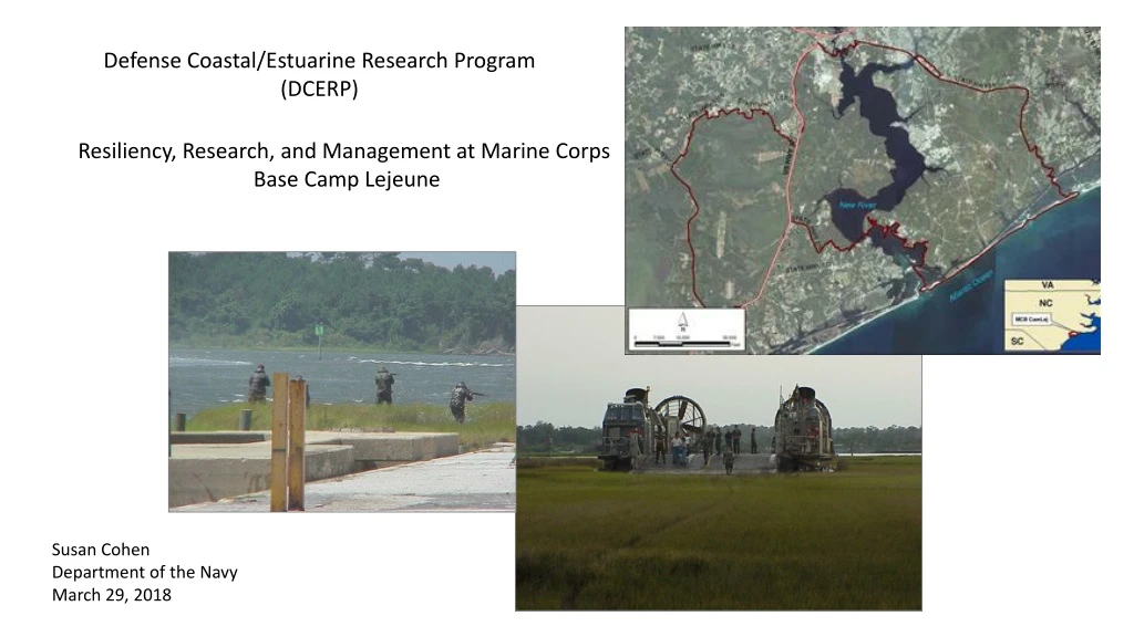
Defense Coastal/Estuarine Research Program (DCERP) Resiliency, Research, and Management at Marine Corps Base Camp Lejeune • Susan Cohen • Department of the Navy • March 29, 2018
Why is resilience important? Climate Change and Sea Level Rise • Climate change and SLR have emerged as key threats of the 21st century to national security. • 128 coastal installations (28% of 456 US installations); risk of inundation and flooding due to SLR and storm surge “…needs must be met in a manner that is maintainable over long time horizons, is response to changing requirements and accounts for new challenges… Resilience = Managing systems so they can absorb impacts without significant change in condition or function
What is challenges resilience at installations?- • multiple scales of stressors • (installation, landscape, regional, national challenges) • man-made stressors • natural stressors Courtesy of USACE, Savannah District Man-made Stressors Courtesy of Georgia Department of Economic Development Natural Stressors Source: Godfrey and Godfrey, 1976
Defense Coastal/Estuarine Research Program (DCERP) – Marine Corps Base Camp Lejeune, NC think about what you know, important drivers, connections among ecosystems, gaps that prevent us from understanding the important drivers and things that force these systems? • DoD funded study • 10-years 2007 - 2017 Integrated, monitoring and research program Studied 4 different ecosystems at MCBCL *Aquatic/Estuarine *Coastal Wetlands Coastal Barrier Terrestrial uplands
DCERP’s Technical Objectives 1. Understand the function and processes of ecosystems and their connections at MCB Camp Lejeune, from observations and measurements. (What are the drivers/stressors? How do we measure them?) 2. Determine how ecosystem processes respond to climate change. 3. Develop models, tools, and indicators to evaluate current and projected future ecosystem state changes and translate scientific findings into information for installation managers 4. Develop a coastal carbon budget
Aquatic/Estuarine - New River, tributary creeks, and New River estuary • What are the water quality challenges to the estuary? • What are the system drivers, stressors, and source of stressors (how does it work)? • Is the NRE a source or sink for carbon? • Will managing water quality be more challenging in the future with population growth and land use and climate change? • How is MCBCL already managing for resilience?
New River Estuary Research & Monitoring Monitoring Experimentation AVP Modeling AVP Management
Estimated monthly nitrate+nitrite load (g/ha) from MCB Camp Lejeune to the New River Estuary from 2008 through 2015. The annual contribution of external nitrogen (N) sources to the NRE. Nutrient loading is largely governed by river flow (impacted by future climate shifts in precipitation?)
Impacts of Future Climatic and Human Stressors on Water Quality Estuarine Simulation Model Monitoring The interactive effects of nutrient loading and climate warming were assessed by running the model with nutrient loading reduced by half (0.5 times), and with this same reduction concurrent with a +5°C warming (0.5 times, +5°C). Experimentation Modeling Management Values represent means over the period 2007-2015.
Conclusions and Management Implications • The estuary is sensitive to N loading due to long residence time (river flow) • Current N sources are largely off-base in upper watershed • Overall low contributions of nutrient loading from Camp Lejeune to the NRE are positive, but past trends do not guarantee no change in the future – monitor. • Climate warming will require larger load reductions to achieve the same level of water quality improvement achievable under current conditions • Consequently, managing water quality within the estuary will require a watershed approach A comprehensive management effort among MCBCL, Onslow County, and the City of Jacksonville will be required to reduce nutrient loadings into the estuary from all point and nonpoint sources in the watershed
Coastal Wetlands • Are the MCBCL marshes vulnerable to drowning by SLR? • What are the system drivers, stressors, and source of stressors (how does it work)? • Will current marsh species remain or change as sea level rises? • Are the marshes a sink for carbon? • Can adaptive management actions now help the marshes remain resilient in the future? • How is MCBCL already managing for resilience?
Coastal Wetlands Monitoring & Research • Marsh Elevation • Shoreline Mapping • Sediment Supply • Ecosystem Productivity • Marsh Exchanges • Carbon Burial • Predict Marsh Resilience • Thin Layer Application Monitoring Experimentation Models Management
Models project good mainland marsh sustainability 2013, Initial 2100, SLR = 0.8m 2065, SLR = 2.5m 2100, SLR = 2.5m • marsh geomorphology model. • General pattern of increasing marsh area through time and for faster rates of SLR until highest scenarios (then loss) • Migration into uplands compensates for limited drowning • Similar pattern across U.S. Atlantic coast marshes Spartina Juncus Upland Water
Backbarrier island marshes squeezed between ICW and island rollover. 1956 1989 • Management of the ICW may alter sediment supply and increase marsh shoreline erosion and loss of habitat • ICW doubled in width over 66 yrs; 65 m (1938) to 150 m (2004) • Recent erosion rates have declined with channel widening • Boat wakes • Compounded by island washover • Onslow Beach has little space for new marsh to form landward making the decline persistent 2009 ICW Boat Wakes Mile Hammock Bay
Management Implications and Recommendations • NRE marshes: Monitor fringing bank marshes and implement engineered solutions for those adjacent to built infrastructure as needed. • Living shorelines • Thin layer application (TLA) • Allow shoreline erosion where possible to maintain local sediment supply • Mainland marshes along the ICW: Allow transgression into low slope uplands. • Count on higher carbon burial in the future • Backbarrier Island Marshes along the ICW: Engineered solutions. • TLA to combat marsh fragmentation • Engage USACE on ICW management
Thin layer disposal of dredged material Benchmark and WL logger ~25 yrs of sediment in 2 weeks Sand dredged from ICW to experimental plots
You don’t need a large research program to do resilience. You are probably doing some management for resilience now. “A formalization of common sense for decision problems which are too complex for informal use of common sense’’ (Keeney, Decision Analysis, 1982). We don’t want to leave it to intuition and chance – whatever you do, formalize your actions to enable learning from them. Try to quantify resilience - measurable and testable metrics to define objectives, monitor change and evaluate management actions. Learn the effects of management on natural systems and apply that to improve management over time. (Brown and Williams 2015)
susan.cohen@usmc.mil https://dcerp.rti.org/#/