Download
1 / 19
190 likes | 264 Vues
Leverage GPS for precise control over communications, reduce power consumption, enhance routing protocols, and enable spatial addressing in smart sensor networks. Experiment with Java APIs for portability and topographical map interfaces. Targeting energy-efficient sensor node operations.

E N D
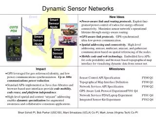
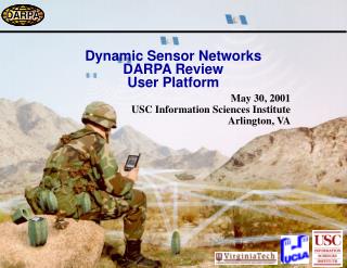
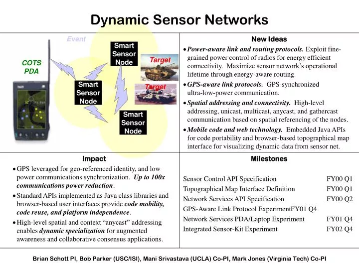
Impact GPS leveraged for geo-referenced identity, and low power communications synchronization. Up to 100x communications power reduction. Standard APIs implemented as Java class libraries and browser-based user interfaces provide code mobility, code reuse, and platform independence. High-level spatial and context “anycast” addressing enables dynamic specialization for augmented awareness and collaborative consensus applications. New Ideas Power-aware link and routing protocols. Exploit fine-grained power control of radios for energy efficient connectivity. Maximize sensor network’s operational lifetime through energy-aware routing. GPS-aware link protocols. GPS-synchronized ultra-low-power communication. Spatial addressing and connectivity. High-level addressing, unicast, multicast, anycast, and gathercast communication based on spatial referencing of the nodes. Mobile code and web technology. Embedded Java APIs for code portability and browser-based topographical map interface for visualizing dynamic data from sensor net. SmartSensorNode SmartSensorNode SmartSensorNode Dynamic Sensor Networks Event Target COTSPDA Target Milestones Sensor Control API Specification FY00 Q1 Topographical Map Interface Definition FY00 Q1 Network Services API Specification FY00 Q2 GPS-Aware Link Protocol Experiment FY01 Q4 Network Services PDA/Laptop Experiment FY01 Q4 Integrated Sensor-Kit Experiment FY02 Q4 Brian Schott PI, Bob Parker (USC/ISI), Mani Srivastava (UCLA) Co-PI, Mark Jones (Virginia Tech) Co-PI
DSN is focusing on three SenseIT areas: 1) Platforms GPS-synchronized ultra-low-power communication experimental platform. 2) Distribution and Aggregation Network boot-up, low-power link protocols, power-aware routing, and spatial addressing. 3) Declarative Language and Execution Environment Topographical map interface. Java APIs for portability. sensor network emulation for rapid application development. SmartSensorNode SmartSensorNode SmartSensorNode Dynamic Sensor Networks Target COTSPDA Target
The primary purpose of the platform is to experiment with using GPS synchronization to provide precise control over transmit/receive on radio. Uses COTS hardware/software to minimize cost and maximize code portability. No attempt to miniaturize subsystems. Comm Subsystem GPS Radio DSN Experimental Platform Sensor Subsystem Serial port Serial port / TOD GPS Antenna Comm Antenna Sensors PDA Application specific processing done in COTS PDA. Assumed in sleep mode unless activated by Comm Subsystem. May have other high-power sensors in PCMCIA slot. Comm Subsystem Synchronizes radios using GPS signal. Can store/forward packets in sensor net and perform routing without PDA. Goal: Runs on solar cell. Sensor Subsystem Contains sensors, signal conditioning, signal processing, and optionally protocol processing to eliminate PDA for light-weight sensor node.
DSN Comm Subsystem (Concept) Clock Oscillator TOD to Sensor Subsystem Sleep Mode Variable Ratio Divider TOD (Time Of Day) Data Timing CLK IN Serial Port Controller Microcontroller Data Buffer To PDA GPS Radio GPS Antenna Comm Antenna To Sensor Subsystem External Devices (i.e.. Long-range radio) 1 pulse per second
Distribution and Aggregation Mani Srivastava UCLA (Co-PI)
Distribution of node location and capabilities to neighborhood application query servers at boot-up and reconfiguration. Low-power link protocols and power-aware routing for energy efficient sensor data distribution. Global spatial addressing that support referencing of individual or groups of sensor nodes by geographic location Capability-based addressing in the local neighborhood. External IP connectivity with DSN network gateways. + + S S - - + S - + S Target - + + S S - - Distribution and Aggregation S Internet S S Sensor Network
S S S S S GPS time Power-Aware Link Protocols • Optimize for computation and communication energy spent per bit distributed (Joules/bit) as opposed to traditional metrics such as throughput. • Combine novel channel state estimation techniques with the capabilities of radios to adapt transmit power and other parameters such as spreading gain and symbol rate. • Exploit GPS reference timing signal to synchronize communication amongsensor nodes and minimizetransmit/receive windows.
14 12 BER=10-4 10 Energy per useful bit (J/bit) BER=10-3 8 6 BER=10-8 4 2 0 200 400 600 800 1000 1200 1400 Packet Length (bytes) Example of Impact of Link Layer Adaptation on Energy Efficiency
Traditional multihop ad hoc routing protocols focus on fast topology changes. Power hot-spots that lead to holes in coverage and network partitioning. Power inefficiency due to signaling messages in quiescent state. Novel DSN routing protocols will focus on maximizing sensor network lifetime. Power-based routing metrics. Leveraging location information during routing. + + S S - - + S + + S S - - - + S - + Target S - Power-Aware Routing Protocols S
Spatial Addressing • Sensor applications typically not interested in node IDs. • Query destination in terms of node location and capabilities. • Any suitable node in target neighborhood can handle the query. • DSN network addressing architecture and routing protocols optimized for the needs of sensor applications. • Node addresses encode their location. • Location-based global routing and capability-based local routing. • Intermediate nodes intelligently filter/combine query responses. • Java-based API for communicating with nodes and node groups. • Both native DSN architecture as well as IPv6 overlay-based will be investigated for use within the sensor network. • External users can tunnel into network across the IPv6 Internet via gateway nodes.
Network Services Library provides multihop connectivity and higher-level networking services. Java API choice provides portability to other wired and wireless platforms. Low-level link layer accessible to other efforts implementing their own routing protocols. API also supports DSN emulation environment. Spatial addressing Power-aware spatial routing Low-power link protocols DSN Network Services API Applications Java-based API Run-time Environment Sensor Network Emulation Sensor Node Hardware
ns-based DSN Simulation • ns will be used as the primary DSN simulation platform. • Simulation of link and routing protocols. • Comparison of alternative addressing architectures. • Collaboration with Deborah Estrin’s SCADDS to define common ns modules and interfaces. • Preliminary interaction already started. • ns module for DSN protocol stack will be made available to other members of SenseIT community.
User Interface • PDA-based platform • Windows CE • Java 2 (Micro Edition) • Color screen • Pen-based interface • Connects to DSN Comm Subsystem by serial port. • Interface will easily operate on more powerful Java platforms.
Topographical Interface Any tracked vehicles in this region? • Topographical map interface to provide network status visually. • Queries can be geographic, by sensor id/capabilities, or be application specific. • Input using pop-up forms/menus. • Browser plug-in approach to allow multiple applications to run on the same map. • User query translated to query language defined by other SenseIT effort(s).
Sensor Network Query Action • User submits query via map browser interface. • Local application (one of several) interprets query. • Query sent using query language over network. • Query arrives at appropriate application query server based on geographic address. • Query is sent to appropriate sensor nodes. • Local Java application acts on query.
Java Emulation Environment • Java-based sensor network emulation tools for application development. • Allows for testing of components before all hardware is ready. • Allows for testing on a larger number of sensors nodes than available. • The goal is to enable rapid application development by providing source-codecompatibility betweena workstation emulator and sensor node.
Summary New Ideas • Power-aware link and routing protocols. Exploit fine-grained power control of radios for energy efficient connectivity. Maximize sensor network’s operational lifetime through energy-aware routing. • GPS-aware link protocols. GPS-synchronized ultra-low-power communication. • Spatial addressing and connectivity. High-level addressing, unicast, multicast, anycast, and gathercast communication based on spatial referencing of the nodes. • Mobile code and web technology. Embedded Java APIs for code portability and browser-based topographical interface for visualizing dynamic data from sensor net. Impact • GPS leveraged for geo-referenced identity, and low power communications synchronization. Up to 100x communications power reduction. • Standard APIs implemented as Java class libraries and browser-based user interfaces provide code mobility, code reuse, and platform independence. • High-level spatial and context “anycast” addressing enables dynamic specialization for augmented awareness and collaborative consensus applications