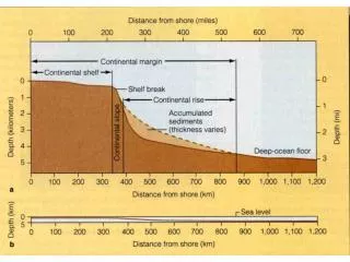
Continental Margin settings
Continental Margin settings. 22. 400-250 Ma: Japanese-type Offshore subduction.
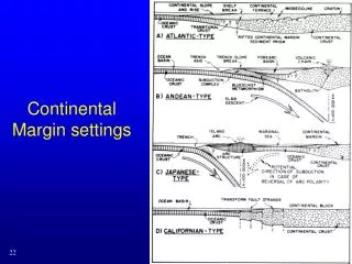

Continental Margin settings
E N D
Presentation Transcript
400-250 Ma: Japanese-type Offshore subduction • The ocean offshore widened and aged until it became unstable to subduction, which initiated sometime in the early Paleozoic under an offshore arc, with a steadily closing marginal sea attached to the North American plate. 23
Devonian (370 Ma). Carbonate deposits continue to dominate the continental shelf. Significant changes in sea level have incised canyons into the shelf
View to west of previous slide. The Antler arc approaches SW North America, plowing into slope-rise deposits off the continent. As the arc progresses eastward, it will thrust these deep water deposits onto the continental shelf
400-250 Ma: Japanese-type Offshore subduction • In the late Devonian, this offshore arc ran up against the North American margin in the Antler orogeny The arc terrane ended up accreted to the continent, overlying the miogeocline across the Roberts Mountain Thrust Fault The orogeny ends when the arc terrane is transferred to the North American plate and a new subduction boundary is initiated offshore. 26
Mississippian (340 Ma). The colliding Antler arc shoved strata deposited in deep water over the continental shelf. The weight of the thickened crust caused eastern Nevada and western Utah to subside and thick Upper Devonian and Lower Mississippian strata formed there. Farther east a broad carbonate shelf blanketed much of the Western Interior.
View to west of previous slide. Some parts of the Antler arc possibly collided with the off shore continental blocks. Here subduction continued but the polarity of the subduction (direction of dip of subduction zone) reversed so that subduction now dipped eastward. One or more of these portions of the reversed Antler arc may have been the precursor of the McCloud arc, a Late Paleozoic tectonic element of western North America. Some geologists interpret the McCloud arc to be exotic to North America
Pennsylvanian (310 Ma). Huge changes in paleotectonics affected western North America. The Ancestral Rockies rose across the southern western interior. The Antler Mountains were being worn down by erosion and began subsiding in some areas. A marine basin covered most of western Utah and eastern Nevada.
View to west of previous slide. In this interpretation, the Stikine fragment of the southern McCloud arc migrated westward while the Quesnell fragment of the Northern McCloud arc remained near western North America. The transform fault between the two may also have truncated SW North America during the Late Pennsylvanian and Permian. Follow this interpretation and watch for a contrasting one in the Permian and Mesozoic
Permian (280-270 Ma). Parts of the Ancestral Rockies remain high and shed sediments into adjacent basins. The Havallah back arc basin expands over the site of the previous Antler Mountains
View to west of previous slide. The Stikine fragment has moved NW to a position west of the Quesnell fragment. In other words, the McCloud arc is a double arc; the western portion was transported along a transform fault
400-250 Ma: Japanese-type Offshore subduction • After a couple of arc-polarity reversals, the same thing happened again, more or less, in the Early Triassic Sonoma orogeny, bringing a new sequence of oceanic rocks on top of the miogeocline and the Antler rocks. • The island arc so accreted forms the basement for the western Sierra Nevada batholith 34
Latest Permian (250 Ma). The Western Interior, like most continental regions around the Earth, was well above sea level at this time
View to west of previous slide. The Stikine arc collapses against the Quesnell arc. The Havallah basin is thrust eastward over the continental shelf and the Sonoman orogeny occurs. Oceanic plateaus, derived from the Tethyian Ocean half-way around the globe, are caught against and between the various subduction zones. This is how this interpretation resolves "exotic elements" within arcs not exotic to North America
Permian Exotic Paleogeography (270 Ma). In this interpretation, the McCloud arc is a single arc separated from North America by a broad back arc basin, the Havallah basin. The Stikine arc is out of view to the west and interpreted as exotic to North America
Latest Permian Exotic Paleogeography (250 Ma). The McCloud arc collapses against North America and the Sonoma orogeny forms. Tethyian oceanic plateau fragments are accreted along the Cache Creek forearc basin. The plateau fragments preceded the arrival of exotic Stikine arc, still out of view to the west
Early Triassic (240 Ma). A broad fluvial and shallow marine depositional system (the Moenkopi Formation) covers much of the southern western interior. To the west, the Stikine and Quesnell elements of the McCloud arc collide and in turn collapse the Havallah back arc basin as the Sonoman orogeny continues. The Cache Creek forearc complex is trapped between the two arc elements
View to west of previous slide. Oceanic plateau fragments continue to accrete to western North America and the ocean plate subducts below the continent. As subduction continued, the Cordilleran arc became established
Eastern Klamath Belt • Rocks are Cambrian to Triassic in age • Consist of metamorphosed andesitic volcanic rocks from an oceanic arc as well as cherts • Emplaced during Antler orogeny • Contains Trinity ophiolite • Similar to Shoo Fly terrane in northern Sierra Nevada • Old island arc and ophiolite is the ocean crust on which it stood
Central Metamorphic Belt • Lies on the Trinity thrust fault • Rocks composed of schists, marbles, and amphibole gneisses • Rocks were subjected to higher heat and pressure as they were dragged beneath the Eastern Klamath belt during Antler event
Western Paleozoic and Triassic Belt • Separated into several smaller terranes: • Rattlesnake Creek – contains late Triassic to early Jurassic metavolcanics and chert • Hayfork/Sawyer’s Bar – contains Jurassic oceanic metavolcanics and metachert • North Fork/Stuart Fork – contains late Triassic metamorphic rocks associated with high pressure and low temperature (subduction zone) • Stuart Fork terrane is similar to Feather River terrane in northern Sierra Nevada
Western Klamath Belt • Josephine ophiolite is the centerpiece – one of oldest and most complete pieces of oceanic crust, it contains a complete section through oceanic crust • Overlain by Jurassic metasedimentary rocks of Galice Formation
Franciscan Complex • Separated from the Western Klamath Belt by the South Fork Mountain Thrust • Considered a northern extension of the Coast Ranges