
Coastal Vulnerability Index for Small Islands: Puerto Rico and US Virgin Islands
This study presents a modified Coastal Vulnerability Index (CVI) for small islands to assess their vulnerability to sea level rise. The CVI accounts for shoreline composition, sea level change, slope, and shoreline change, providing a quantitative measure of vulnerability. The study identified the most and least vulnerable islands using AMBUR software. The improved CVI can be applied globally, enhancing coastal management and planning.

Coastal Vulnerability Index for Small Islands: Puerto Rico and US Virgin Islands
E N D
Presentation Transcript
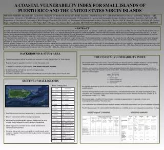
PERISON-PARRISH, Elizabeth M.1, JACKSON, Chester W. Jr2, RUNYAN, Ryann M.3, BUSH, David M.3, SIEMER, Kyle W.4, LLERANDI-ROMÁN, Pablo A.5, and NEAL, William J.6, (1) Geosciences, University of West Georgia, Carrollton, GA 30118, eperiso1@my.westga.edu, (2) Department of Geology and Geography, Georgia Southern University, Statesboro, GA 30460, (3) Department of Geosciences, University of West Georgia, Carrollton, GA 30118, (4) Department of Environmental Science, University of Toledo, 2801 W. Bancroft, Toledo, OH 43606, (5) Geology Dept, Grand Valley State University, 118 Padnos Hall of Science, One Campus Drive, Allendale, MI 49401-9403, (6) Department of Geology, Grand Valley State University, Allendale, MI 49401 ABSTRACT A Coastal Vulnerability Index (CVI) incorporates geologic and physical process variables that are dominant in the coastal system, and provides a relative yet quantitative measure of vulnerability. The CVI accounts for the dynamic nature of the coast and reflects its sensitivity to change with respect to rising sea level. A CVI helps provide a scientific basis for coastal management. There are well over 100 small islands and cays surrounding Puerto Rico and the U. S. Virgin Islands. Twenty islands were selected for inclusion in the study because they exhibit either historical, cultural, recreational, or scientific importance, or some combination of factors. The CVI presented here is modified based on previous work of Gornitz and Kanciruk (1989), Shaw et al. (1998), and Thieler and Hammar-Klose, (1999), Wood (2009), and others. CVI parameters are weighted on a 1-5 scale. For each parameter, 1 denotes a very low probability of coastal change, and 5 the highest probability of coastal change. The beauty of a CVI is that it can incorporate a wide range of types of input parameters, but as long as they are weighted, their relative importance is shown. Our CVI incorporates four parameters: shoreline composition, sea level change, slope, and shoreline change. Although developed with Puerto Rico and the U. S. Virgin Islands in mind, it should be applicable to any island setting. AMBUR software (Jackson et al., 2012) was used to analyze shoreline change and the newly developed AMBUR-HVA tool was used to calculate the CVI, defined as the square root of the product of the ranked variables divided by the total number of variables. After analyzing the 106 km of shoreline contained within the 20 study islands, the three islands rated most vulnerable to coastal change are Isla Morrillito (mean CVI = 2.65), CayoRatón (2.74), and Isla de los Palomas (2.81). The three least-vulnerable rated islands are Cayo Río (mean CVI = 6.32), CayoRatones (6.35), and Palominitos (6.95). A COASTAL VULNERABILITY INDEX FOR SMALL ISLANDS OF PUERTO RICO AND THE UNITED STATES VIRGIN ISLANDS • BACKGROUND & STUDY AREA • Coastal resources are vital to the culture and economy of Puerto Rico and the U.S. Virgin Islands • Majority of regional population resides in or near the coastal zone • In addition to modified CVI assessment, other project outcomes included: • land loss estimates & historical shoreline change analysis • Coastal vulnerability maps • Outreach & education for local residents and officials concerning the coastal zone in Puerto Rico • SELECTED SMALL ISLANDS • Small islands have historical, recreational, or scientific significance • Discrete environments without much previous study • Naturally intact systems where testing of models may be more • reliable; mostly removed from anthropogenic interference • Same “big picture” processes at work in both environments • (climatic/oceanic/geologic) • Shoreline change will occur more rapidly on small islands, which • suggests analysis of these environments as a means of visualizing • future change Table 1. Study Sites
Cayo Ratón MAPPED CVI SHORELINE CHANGE Table 2. CVI and Shoreline Change Calculations Isla de Palomas Cayo Ratón • DISCUSSION • Calculated CVI values represent a relative yet quantitative estimate of coastal vulnerability to sea level rise. • Cayo Raton, Isla Morrillito, and Isla de lasPalomas exhibited lowest coastal vulnerability to sea level rise • CayoRatones, Palominitos, and Cayo Rio exhibited highest vulnerability to sea level rise • The most exciting aspect of project outcome was the improved accuracy of the modified CVI -Instead of producing a CVI for Puerto Rico and the U.S. Virgin Islands, the modified CVI can be used to estimate coastal vulnerability anywhere in the world • Further, the AMBUR-HVA program was modified by Chester Jackson to better handle coastal features found in the Caribbean such as cays or smaller islands with diverse geological and biological frameworks. Isla Morrillito Isla de Palomas Palominitos Sea level rise scenarios through 2150 compiled by the Puerto Rico Climate Change Council. (PRCCC, 2013) Isla Morrillito • REFERENCES • Gornitz, V., White, T. W., and Cushman, R. M., 1991, Vulnerability of the U. S. to Future Sea Level Rise in Proceedings, 7th Symposium on Coastal and Ocean Management: Long Beach, California, American Society of Civil Engineers , p. 2354-2368. • IPCC, 2007, Climate Change 2007: Synthesis Report in Core Writing Team, Pachauri, R.K and Reisinger, A., eds.,Contribution of Working Groups I, II and III to the Fourth Assessment Report of the Intergovernmental Panel on Climate Change: Geneva, Switzerland, IPCC, 104p. • Pendleton, E. A., Thieler, E. R. and Williams, S. J., 2004a, Coastal Vulnerability Assessment of irgin Islands National Park (VIIS) to Sea-Level Rise:, U. S. Geological Survey Open-File Report 2004-1398, 33 p. • Puerto Rico Climate Change Council (PRCCC), 2013, State of Puerto Rico’s Climate 2010-2013 Executive Summary: Assessing Puerto Rico’s Social-Ecological Vulnerabilities in a Changing Climate, (electronic version): San Juan, PR, Puerto Rico Coastal Zone Management Program, Department of Natural and Environmental Resources, Office of Ocean and Coastal Resource Management (NOAA-OCRM), p. 27. • Thieler, E. R. and Hammar-Klose, E. S., 1999, National Assessment of Coastal Vulnerability to Sea-Level Rise: Preliminary Results for the U.S. Atlantic Coast: U.S. Geological Survey Open-File Report 99-593, URL: http://pubs.usgs.gov/of/1999/of99-593/. Cayo Ratones Cayo Ratones Cayo Rió Palominitos • ACKNOWLEDGEMENTS • Puerto Rico Sea Grant • University of West Georgia Student Research Assistantship Program (SRAP) • University of West Georgia Faculty Research Grants • Geological Society of America Student Travel Grant Program Cayo Rió


