Download
1 / 29
290 likes | 621 Vues
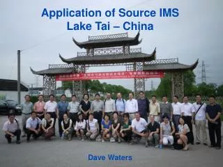
Application of Source IMS Lake Tai – China Dave Waters. Lake Tai (or Taihu). Lake Tai (or Taihu), is the 3rd largest freshwater lake in China (southern part of Yangtze River delta). Total area of Lake Tai approx. 2,338 km 2 , average depth of 2m

E N D
Application of Source IMS Lake Tai – China Dave Waters
Lake Tai (or Taihu) Lake Tai (or Taihu), is the 3rd largest freshwater lake in China (southern part of Yangtze River delta). Total area of Lake Tai approx. 2,338 km2, average depth of 2m The lake provides water to 30 million residents. Lake Tai has been increasingly polluted due primarily to rapid economic growth and increased population in the basin area
Water Crisis in Lake Tai Large algal bloom outbreaks in Lake Tai since 1990. The most significant algal bloom broke out in 2007 in Mei Liang Bay near the Wuxi City, and led to the " Wuxi City Water Crisis”. Wuxi City Yixing City Suzhou City Lake Tai N Huzhou City (Google Earth)
2007 Water Crisis in Lake Tai - Water quality worse than Class V of the Surface Water Quality Standard (GB3838-2002). - Tap water supply in Wuxi City had to be temporarily terminated due to the crisis. - Led to the development of the Lake Tai Master plan 2008
Project • Australian China Environmental Development Partnership (ACEDP) • 5 year, $25Million Aust Gov. AusAID initiative • Aimed at supporting and enhancing Policy development in China • Working in areas of mutual interest – focus on water resource management
Aus Lake Tai Cluster AUS Cluster Lake Tai Team include: Earth Systems Melbourne Water DSE Victoria EPA Victoria Hyder Consulting Extension Activities: • Existing AUS partners + • DPI Victoria • eWater Cooperative Research Centre • Hunter Water Corporation
Chinese Lake Tai Cluster • Lake Tai Basin Authority, China • Nanjing Institute of Geography and Limnology, Chinese Academy of Science (NIGLAS) • Environmental Research Institute, Suzhou • Agricultural Bureau, Suzhou
The Lake Tai Project • Demonstration of eWater tools November 2010 • Resulted in a 1 year project - commenced March 2011 • Workshops China/Australia 2011 • Base models and scenario development • Final meeting January 2012
SOURCE IMS PROJECT OBJECTIVES • Building capacity within the Chinese working group • Apply Source IMS model to a pilot area (Dongshan Peninsula) • Model demonstration to improve non point source nutrient management into the lake and inform policy
Model Development • Pilot Area Dongshan Peninsula (82 km2) • Modelling water Quantity, Nitrogen, Phosphorus • 7 landuse categories of interest • Assessing relative contribution for each landuse • Running a range of scenarios to look at management options to reduce nutrient export to Lake Tai
Lake Tai N
Landuse Upland Trees High Density Urban Low Density Urban Vegetables Industrial Aquaculture Ponds
Modelling challenges • Data access • Data availability • Replication of aquaculture pond management • Replication of gate closure/pumping of rainfall runoff to lake
Scenarios • Relocation of STP plant • Conversion of remaining 20% septics • Major wetland construction • Improved management of inputs
Conclusions • Project has provided great exposure for eWater • Source IMS flexibility key to success • Versatility to be able to model rural/urban and regulated areas and simplicity attractive features to Chinese delegation
The Lake Tai Project Activity Objectives: Contribute to successful environmental governance mechanisms at Municipal, Province and Basin levels. Assist greater use of science-based planning, management and interventions to support lake and river basin management to improve lake conditions 3) Contribute to a substantial decrease in the frequency and intensity of algae blooms as a result of specific and modern IRBM, science and management technologies.