Download
1 / 1
10 likes | 234 Vues
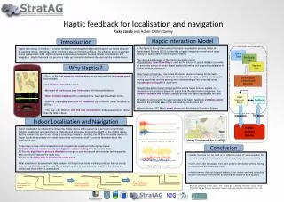
Building plan. Building plan. Building plan. Figure 1. Figure 2. Figure 3. Route track improved through step counting . Route track localised against building plan. Raw route data from accelerometer and compass. Yes. No. Text:. Yes. No. Image:. Landmark:. Yes. No. Audio:. Yes.

E N D
Building plan Building plan Building plan Figure 1. Figure 2. Figure 3. Route track improved through step counting Route track localised against building plan Raw route data from accelerometer and compass Yes No Text: Yes No Image: Landmark: Yes No Audio: Yes No Haptic: Yes No Haptic feedback for localisation and navigation Ricky Jacob and Adam C Winstanley Haptic Interaction Model Introduction • In the figure to the right we extend the haptic visualisation process model of Paneels and Roberts (2010) to describe a haptic-interaction model which relies heavily on spatial data to drive decision making. • The various components of the haptic interaction model: • Spatial Data: OpenStreetMap is used as the source of spatial data as it provides an extensive source of vector-based spatial data with a rich supporting database of spatial attribute information. • Data Fusion component: It provides the spatial decision making for the haptic model. In our case this the data fusion component is made up of the shortest path routing algorithms and the parsing and understanding of the computed route. Cloudmade routing API is used here. • Haptic interaction model component: It is where haptic actions, signals, or interactions are produced based on output from the data fusion component. The vibration alarm in the phone is used to provide the haptic feedback to the user. • Feedback component: The user considers the haptic feedback and takes action based on the physical state of the surrounding environment too. • Haptic device: HTC Magic smart phone with the Android Operating System. Haptic technology, or haptics, is a tactile feedback technology that takes advantage of our sense of touch by applying forces, vibrations, and/or motions to the user through a device. The vibration alarm in a smart phone enabled with GPS, digital compass and accelerometer can be used to help in localisation and navigation. Haptic feedback can provide a ‘neck-up’ interaction between the user and the mobile device. Why Haptics? • Touch is the first sense to develop when we are born and the last sense used before death. • It is 20 times faster than vision. • No need of continuous user interaction with the mobile device. • Need not be a map expert to understand the way haptic feedback works. • Humans are highly sensitive to vibrations up to1000Hz (most sensitive at 250Hz) • The user can interact with the real environment and people around rather than the mobile device. Image Indoor Localisation and Navigation Indoor localisation is to determine where the mobile device or the person is in an indoor environment. Outdoor localisation and navigation is efficiently and accurately done using a GPS on the mobile device. But the moment the user is very close to a building or enters a building, the GPS in the mobile device no longer functions accurately or in most cases does not function at all to provide feedback about the position the user. Three steps to help indoor localisation and navigation as explained in the figures below: 1.) Collect the raw accelerometer and digital compass reading from the mobile device 2.) Run the algorithm to process this data to recognize user movement and consider techniques like step counting to improve the route track 3.) Use the building plan to localise the route track Initial collection of accelerometer data samples for the process looks promising and can help us clearly determine a step taken by the user. Some sample graphs of accelerometer data from the device are plotted and show different user actions. Using Cloudmade for routing Figure 1. Walking followed by a standing still Conclusion • Haptic feedback can be used as an effective mode of communication for navigation using the vibration alarm with varying frequency and sensitivity. • Users were able to navigate from start point to destination without having to interact with the device at all times. • Accelerometer data can be used to detect user motion and help us localize people in an indoor environment by combing the data with building plans. Figure 2. Walking downstairs Research presented in this poster was funded by a Strategic Research Cluster Grant (07/SRC/I1168) by Science Foundation Ireland under the National Development Plan. The authors gratefully acknowledge this support.