Climate Zones
Climatology study of Earth’s climate and the factors that affect past, present, and future climatic changes. Climate describes annual variations of temperature, precipitation, wind, and other weather variables. Studies of climate show extreme variables over time to determine the normals .

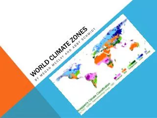
Climate Zones
E N D
Presentation Transcript
Climatology study of Earth’s climate and the factors that affect past, present, and future climatic changes. Climate describes annual variations of temperature, precipitation, wind, and other weather variables. Studies of climate show extreme variables over time to determine the normals.
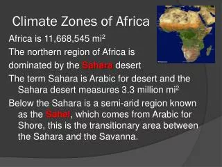
Climate Zones • The Tropic of Cancer and Tropic of Capricorn mark the northernmost and southernmost latitudes at which the sun may be seen directly overhead . .
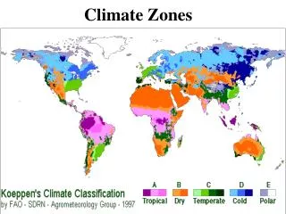
Climate Classification: • Koppen classification system: a widely used classification system for climates based on the average monthly values of temperature & precipitation. It also takes into account the distinct vegetation found in different climates.
The Köppen system recognizes five major climate types based on the annual and monthly averages of temperature and precipitation. Each type is designated by a capital letter. A - Moist Tropical Climates are known for their high temperatures year round and for their large amount of year round rain. B - Dry Climates are characterized by little rain and a huge daily temperature range. Two subgroups, S - semiarid or steppe, and W - arid or desert, are used with the B climates. C - Humid Middle Latitude Climates land/water differences play a large part. These climates have warm,dry summers and cool, wet winters. D - Continental Climates can be found in the interior regions of large land masses. Total precipitation is not very high and seasonal temperatures vary widely. E - Cold Climates describe this climate type perfectly. These climates are part of areas where permanent ice and tundra are always present. Only about four months of the year have above freezing temperatures. Further subgroups are designated by a second, lowercase letter which distinguish seasonal characteristics of temperature and precipitation. f - Moist with adequate precipitation in all months and no dry season. This letter usually accompanies the A, C, and D climates. m - Rainforest climate in spite of short, dry season in monsoon type cycle. This letter only applies to A climates. s - There is a dry season in the summer of the respective hemisphere (high-sun season). w - There is a dry season in the winter of the respective hemisphere (low-sun season). To further denote variations in climate, a third letter was added to the code. a - Hot summers where the warmest month is over 22°C (72°F). These can be found in C and D climates. b - Warm summer with the warmest month below 22°C (72°F). These can also be found in C and D climates c - Cool, short summers with less than four months over 10°C (50°F) in the C and D climates. d - Very cold winters with the coldest month below -38°C (-36°F) in the D climate only. h - Dry-hot with a mean annual temperature over 18°C (64°F) in B climates only. k - Dry-cold with a mean annual temperature under 18°C (64°F) in B climates only.
A. Tropical Climates • Constant high temperatures • Heat is sometimes accompanied by up to 600 cm of rain a year. (Tropical rain forests) • Contains some of the most dramatic vegetation
C. Temperate Climates • Humid Subtropical - warm, muggy weather summer and dry and cool in winter (southeastern US) • Marine West Coast – dominated by air flow from oceans, mild winters and cool summers (San Francisco) • Mediterranean – influenced by Mediterranean Sea, warm summers due to lack of currents (Italy & Spain)
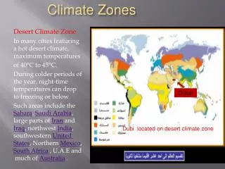
B. Dry Climates • Cover about 30% of Earth’s land area (largest climatic zone) • Continental tropical air dominates • Precipitation low / Vegetation scarce • Intense solar radiation / high evaporation rates • 2 subtypes: Arid-Deserts Semi-Arid –more humid than arid
D. Continental Climates • Clashing tropical and polar air masses. • Rapid and violent changes in weather. • Interior region-lack of sufficient bodies of water. Mild summers / Cold Winters
E. Polar Climates • North of the continental climates and the coldest regions on Earth. Constant cold • Divided into two types: Ice caps and tundra
F. Highland Climate • Cool to Cold • Found in mountainous region • Climate at base different than top INTERACTIVE
Exercise Look up Koppen’s Climate Classification Chart List 4 countries under each of the climates • 1 B. 1 C. 1 D. 1 E. 1 F. 1 2 2 2 2 2 2 3 3 3 3 3 3 4 4 4 4 4 4 Biomes are climatically and geographically defined as contiguous areas with similar climatic conditions on the Earth, such as communities of plants, animals, and soil organisms,[1] and are often referred to as ecosystems.
Climatic Changes: • Ice Age-advanced and retreated over the past 2 million years. Glacial & interglacial periods • El Nino - Periodically the tradewinds slow down which allows the warm waters of the Pacific to stay east which generates an increased amount of moisture in the air which can cause violent storms to California & South America
Natural Changes: • Sunspots - Periods of low solar activity are called Maunder minimum. “Little Ice Age” 1645-1715 (Ice-skating on the Thames River in June 1700’s) (violins) • Earth’s orbit – The shape of the Earth’s orbit appears to change becoming more elliptical over the course of a 100,000 year cycle. Earth passes closer to the sun increasing temperatures. (Ice Ages) • Volcanic Activity– Climate changes due to the immense volcanic dust released into the atmosphere during major eruptions. Dust can remain suspended for several years blocking solar radiation. • Global Warming – Increased CO2 levels Temperature has increased 1.4 degrees since 1880
Hurricanes Hurricane video
Katrina Hurricane Facts • Occur in Summer / Fall June 1 to November 20 • Sun heats areas of the ocean to 82 degrees where warm, moist air risers creating a low pressure area and thunderstorms (Supercell-severe t-storm with updraft) • Upper & surface winds form circular pattern of clouds – tropical depression • Winds exceed 39 mph – tropical storm • Winds reach 74 mph – hurricane, cyclone, or typhoon • Bands of rain up to 300 miles long meet in the eye wall, winds up to • 200 mph spiral upward • Downdrafts of dry air in center creating a calm eye of the storm • Wall of water is called the storm surge as it hits the coastline • Can be 500 miles in diameter and reach 9 miles high • Uses as much energy in a day as ½ million small atomic bombs • Most costly Hurricane Katrina-108 Billion and Hurricane Sandy-68 Billion