Download
1 / 35
350 likes | 417 Vues
Developing a Protocol to Describe and Delineate Episodic Streams on Arid Landscapes FOR PERMITTING UTILITY-SCALE SOLAR POWER PLANTS. R oland H . B rady III B rady and Associates Geologic Services Kris Vyverberg California Department of Fish and Wildlife. Thanks to:

E N D
Developing a Protocol to Describe and Delineate Episodic Streams on Arid Landscapes FOR PERMITTING UTILITY-SCALE SOLAR POWER PLANTS Roland H. Brady III Brady and Associates Geologic Services Kris Vyverberg California Department of Fish and Wildlife
Thanks to: • California Energy Commission (Funding) • Singleton Thibodeaux-Yost (Graduate student, CSU-Fresno) • Carolyn Chainey-Davis (Botanist-Consultant) • Kirk Vyverberg(Field support, editorial review, great camp cookin’)
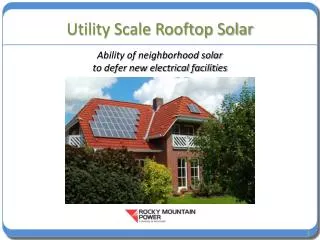
Ivanpah Solar Thermal EGS Largest in world 3500 acres 377 MW Supply 14,000 homes annually Development of utility-scale, solar power plants have high priority to provide much needed electrical energy in CA. Photo and data courtesy BrightSource Energy
21 pending permit applications in CA desert. Proposed plant sitings covers hundreds of thousands of acres. Map courtesy of Los Angeles Times Data Desk.
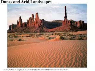
Desert -- area of ephemeral watersheds. Years between flows. 2 mi Project footprint Ivanpah STEGS
IMPORTANCE OF EPHEMERAL STREAMS IN ARID ECOSYSTEMS • Higher biodiversity along stream corridors. • Streams transport water, organic matter; disperse seeds and sediment. • Channels provide elevational connectivity and refuge for animal migration. • “Home” - - softer sediment in stream channel = greater ease of burrowing than on fan. Because ephemeral stream habitats scarce in arid landscapes should be protected whenever possible.
Project Permitting • Environmental permitting process extensive. • Solar thermal (and maybe photo-voltaic) projects permitted through California Energy Commission (CEC). • CDFW responsible for conserving, protecting, and managing California's fish, wildlife, and native plant resources: • Identify potential adverse impacts to fish and wildlife. • Identify measures to eliminate or reduce impacts including avoidance, minimization, and mitigation.
Fish and Game Code (Section 1602) 1600 Lake and Streambed Alteration Agreement “Applies to any work undertaken in or near a river, stream, or lake that flows at least intermittently through a bed or channel. Includes ephemeral streams, desert washes, and watercourses with a subsurface flow.”
1600 requires entity to notify CDFW of any proposed activity or project that may: • Substantially modify a river, stream, or lake; • Substantially divert or obstruct the natural flow; • Substantially change or use any material from the bed, channel, or bank, or; • Deposit or dispose of debris, waste, or other material….. where it may pass into any river, stream, or lake. Damage to jurisdictional streams requires on- or off-site mitigation.
Compliance requires proper recognition of active steams and their delineation = determination if jurisdictional. HOWEVER: • Although delineation = Fluvial geomorphology, commonly conducted by consulting staff having little or no experience in desert fluvial geomorphology. • No consistent protocols for delineating streams. • No consistent terminology for describing ephemeral stream features and processes. • CDFW claim to jurisdictional waterwayshas been inconsistent.
Little communication between stormwater engineers and environmental compliance staff. • Applicants’ general misunderstanding of ephemeral stream features and processes. e.g: • Not recognizing indicators of stream flow = not recognizing presence of stream. • Identifying (incorrectly) streams as “inactive” but notdocumenting features indicating age (soils, pavement, varnish, weathering). • Misinterpreting distributed out-of-channel flow as “sheetflow” (no channel, thus non-jurisdictional).
Although much conceptual and regulatory guidance for perennialstreams, little guidance to assist in task in mapping/delineating ephemeral stream systems: • US Army Corps of Engineers Ordinary High Water. • Application to ephemeral streams doubtful (USACE presently modifying guidelines for arid watersheds). • Stream Processes and Forms in Dryland Watersheds K. Vyverberg, ed., (2010) CDFW.
Negative incentive to document streams at permit site. Guiding principle: Fewer streams = Less mitigation = Less jurisdictional area = Less $$ to client.
Stream “Not a stream” Silurian Hills
Projects Affect Streams • Infrastructure alters natural drainage (roads, buildings, berms). • Site grading removes natural channels (habitat). Water diverted. “Turns off” streams, habitat. Ivanpah STEGS Photo courtesy Los Angeles Times Data Desk. • Water diverted and concentrated downslope => erosion and incision; sedimentation. Often off site impacts to property, infrastructure, and habitat.
Streams Affect Projects • Flooding • Accelerated erosion • Damage to infrastructure • Time delays and mitigation for environmental and off-site damage Genesis SEP Failure to incorporate ephemeral stream processes in project design can have significant consequences on cost and operation.
….and costly delays in permitting process if, upon inspection, permit application does not properly represent conditions on site, must reapply and go to the “back of the line”.
Others are not. “100-yr floodway” Non-jurisdictional Jurisdictional Jurisdictional Non-jurisdictional Non-jurisdictional Non-jurisdictional Jurisdictional Non-jurisdictional
CEC CONTRACT TO DEVELOP PROTOCOLS FOR DELINEATING DESERT STREAMS • Select 6 sites typical of sites for large, solar arrays. • 3 having permit applications and 3 without.
Avawatz Mts Silurian Hills El Paso Mts Lucerne Valley Coxcomb Mts Palo Verde Mesa
Method: Google Earth Pro images on iPad, laid out transects. Field mapped stream features. Plotted on GIS iPad using Garafa GIS program. Photographed hundreds of stream features from 8’ ladder. Excavated 22 soil trenches. Conducted 28 infiltrometer tests. Delineated CDFW jurisdictional streams. Compared with permit applications for 3 sites. WOW!!
Soil pits “Arial” mapping Infiltrometer tests.
RESULTS/RECOMMENDATIONS: Field Guide to Fluvial Indicators. Photographic atlas of ephemeral stream features and landscapes including indicators of antiquity.
Stream “activity”: • “Active” - indicators of flow present or existent connectivity to water source. • “Dormant” - indicators of flow may be absent. Channel isolated from water source but has potential for reactivation w/i lifetime of project (75 years). • “Abandoned” - channel isolated from water source by natural or anthropogenic causes; not part of modern channel system. • “Relict” - abandoned channel having evidence of antiquity due to time/climate change.
Field Data SheetFor use in field assessment. Documents what features are and are not present (presence/absence of flow indicators) indicating channel “activity”.
+ -
Minimum map scale 1” = 500’. Map“watercourse”Map area rather than individual streams (linear).
Jurisdictional Jurisdictional Non-jurisdictional Revised delineation. Permit application delineation.
Oversight.Project overseen by licensed geologist (PG) with experience working in arid watersheds who stamps and signs delineation report.
DISADVANTAGES Requires greater attention to site evaluation. Practitioners learn new protocol. Commonly increases jurisdictional stream length/area (increases mitigation obligation). Increases cost of assessment, but very small (<1/2% of total).
BENEFITS: To Taxpayers: Most effective use of agency time in assessing permit applications. Appropriate oversight of qualified personnel (Licensed Geologist). To project developers: Speeds review of permit application. Reduces chances for rejection by regulators due to faulty delineation. Streamlines field assessment methods. Consistent application of mitigation obligation.
To Environment: Recognizes realistic area and location of stream habitat. Aids in appropriate placement of footprint. Avoidance, mitigation obligation. Protects fragile desert ecosystem without compromising production of electrical energy. Thanks, geologists!!