Download
1 / 34
400 likes | 527 Vues
Plate Tectonics – New Evidence. Alfred Wegener & Continental Drift. No mechanism to move the continents from one place to another Scientists did not know much about the ocean floor dismissed as being eccentric, preposterous, and improbable. Early Studies.

E N D
Alfred Wegener & Continental Drift • No mechanism to move the continents from one place to another • Scientists did not know much about the ocean floor • dismissed as being eccentric, preposterous, and improbable
Early Studies • First Bathymetric Chart in 1855 by U.S. Navy Lieutenant Matthew Maury • underwater mountains in Atlantic • confirmed when laying the trans-Atlantic telegraph cable. • World War I (1914-18) • echo-sounding devices (primitive sonar systems) measure ocean depth • Ocean floor more rugged than thought. • Continuity of submarine mountain chain
World War II & Sea-Floor Topography • Ships and Submarines used SONAR to map the ocean-floor topography • Submarines used topography to hide from ships and had to avoid under-sea topography • Ships used SONAR to find submarines • 1950s -- oceanographic surveys • a great mountain range on the ocean floor, the global mid-ocean ridge, encircled the Earth. • more than 50,000 kilometers (km) long and up to 1000 km across • zig-zags between the continents • Rising about 4,500 meters(m) above the sea floor, • Taller than all mountains in the US except for Mount McKinley (Denali) at 6,194 m • The most prominent topographic feature on the surface of our planet. • Deep Sea trenches -- incredibly deep
Youngest rocks at RidgeOldest furthest away from Ridge • 1968 -- a research vessel, the Glomar Challenger, designed specifically for marine geology studies • Deep-Sea Drilling Project -samples from ocean floor. • Criss-crossed the Mid-Atlantic Ridge between South America and Africa • the ages of the samples • paleontologic • isotopic dating studies
Earth’s Magnetic Field & Polar Reversals • Early 1900’s – Paleomagnetists • Bernard Brunhes in France (in 1906) • MotonariMatuyama in Japan (in the 1920s) • rocks generally belong to two groups according to their magnetic properties • Normal = the magnetic minerals in the rock having the same polarity as that of the Earth's present magnetic field (North is North) • Reversed = the magnetic minerals in the rock having the opposite polarity as that of the Earth's present magnetic field (North is South)
How can this happen? • Currents in Earth’s Liquid Outer Core create the magnetic field • Convection currents of liquid iron and nickel generate an electrical current “dynamo”. • Grains of magnetite behave like little magnets and align with the orientation of the Earth's magnetic field. • Magma cools to form solid rock • Alignment of the magnetite grains is "locked in" • The grains “record” the Earth's magnetic orientation or polarity (normal or reversed) at the time of cooling.
How did they figure this out? • World War II – magnetometers used to detect submarines • 1950s, scientists used magnetometers to study the ocean floor • Odd magnetic variations across the ocean floor • Ocean floor rock, basalt, contains magnetite (a magnetic iron mineral) • Magnetite can distort compass readings • The magnetic variations are not random or isolated! Magnetic striping = a zebra-like pattern alternating stripes of normal & reversed rock laid out in rows on either side of the mid-ocean ridge
New oceanic crust forms continuously at the crest of the mid-ocean ridge • As you move away from the ridge • Crust is cooler • Crust is older • Crust moves away from the ridge crest with seafloor spreading • a. the spreading ridge about 5 million years ago • b. about 2 to 3 million years ago • c. now
Sea-Floor Spreading: Putting it all together • Evidence • Sea-Floor Topography • Young crust at ridges, old crust far from ridges • Magnetic Striping • 1961 – New Questions: • Are mid-ocean ridges structurally weak zones where the ocean floor was being ripped in two lengthwise along the ridge crest? • Could new magma from deep within the Earth rises easily through these weak zones and erupts along the crest of the ridges to create new oceanic crust?
Sea-Floor Spreading: Putting it all together • Harry H. Hess & Robert S. Dietz = seafloor spreading. 1. Crust is added at the ridges • new oceanic crust continuously spread away from the ridges in a conveyor belt-like motion 2. Crust is destroyed at the trenches • After millions of years of moving away from the ridges, oceanic crust descends into very deep, narrow canyons along the rim of the Pacific Ocean basin called trenches
Assumptions • The Atlantic Ocean was expanding. • The Pacific Ocean was shrinking. • The ocean basins were perpetually being “recycled” • the creation of new crust at mid-ocean ridges • the destruction of old oceanic lithosphere at subduction zones
Sea-Floor Spreading: Putting it all together • Thus, Hess' ideas neatly explained • why the Earth does not get bigger with sea floor spreading • why there is so little sediment accumulation on the ocean floor • why oceanic rocks are much younger than continental rocks. • And, the oceanic crust is a natural "tape recording" of the history of the reversals in the Earth's magnetic field.
Continental Drift + Sea Floor Spreading = Plate Tectonics!!!!
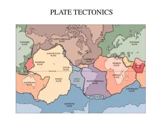
The Theory of Plate Tectonics • The outer layer of the Earth is broken up into rigid plates • These plates are made of the lithosphere = • Crust + the Uppermost Mantle which is “stuck” to the bottom of the crust (peanut butter on bread) • Plates move around on the hot, weak, mobile asthenosphere • Weak zone in the mantle below the lithosphere (jelly)
The Plates • Rigid - movement is minimal within a plate • Plates move relative to each other resulting in their edges having • Earthquakes • Volcanoes • Mountains • The intensity of earthquakes, types of volcanoes, and types of mountains are dependent on how the plates interact • 3 primary types of plate boundaries
Divergent Boundaries • Plates move away from each other • Mostly found at mid-ocean ridges • Crust is made as plates move away from each other and magma oozes up at the ridge
Earthquakes are common at ridge but shallow • Volcanic Activity is prevalent at ridge • Examples: Mid-Atlantic Rise and the Red Sea
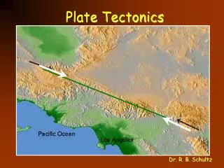
Transform Boundary • Plates move past each other • Accommodate the different types of movement on a sphere
Earthquakes very common and can be severe • Volcanoes absent • Examples: San Andreas Fault and Mendicino Boundary
Convergent Boundary • Plates move toward each other • Three different types • Ocean-Continent • Ocean-Ocean • Continent-Continent
Ocean-Continent Convergent • More dense oceanic lithosphere is subducted under less dense continental lithosphere forming a trench • Continental Volcanic Arcs result as the water in the subducted oceanic lithosphere is released and melting occurs in the mantle below the continent.
Earthquakes are severe, common and vary in depth. • Continental Volcanic Arcs • Examples: Cascade and Andes Mountains
Ocean-Ocean Convergence • The older, colder more dense oceanic lithosphere is subducted beneath the younger, warmer less dense segment. • Deep trenches form at edge of subduction zone
Volcanic Island Arcs form as water is released into the mantle causing melting • Earthquakes are common and severe, varying in depth • Often result in Tsunamis. • Examples: Japan and Indonesia
Continent-Continent Convergence • Continental lithosphere cannot be subducted because it is not dense enough. • As the continents are forced together, they form huge mountains
Earthquakes are severe and common. • Volcanism is rare. • Examples: Himalaya, Alps, and Appalachia