Geophysical Acoustics Research
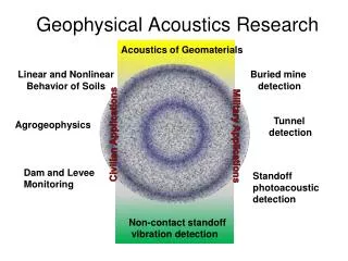
Geophysical Acoustics Research. Acoustics of Geomaterials. Linear and Nonlinear Behavior of Soils. Buried mine detection. Tunnel detection. Agrogeophysics. Civilian Applications. Military Applications. Dam and Levee Monitoring. Standoff photoacoustic detection.

Geophysical Acoustics Research
E N D
Presentation Transcript
Geophysical Acoustics Research Acoustics of Geomaterials Linear and Nonlinear Behavior of Soils Buried mine detection Tunnel detection Agrogeophysics Civilian Applications Military Applications Dam and Levee Monitoring Standoff photoacoustic detection Non-contact standoff vibration detection
The Porous Media group research focuses on the interaction of sound with the ground surface, near surface geophysics, and laser based remote vibration measurements. Current work include linear and nonlinear acoustic behavior of soils, agrogeophysics, dam and levee monitoring, seismic tunnel detection, detection of buried mines, application of multiple beam laser Doppler vibrometers, and standoff detection of explosives.
Craig Hickey, PhD (Geophysics) James Chambers, PhD (Mechanical Engineer) SlavaAranchuk, PhD (Electrical Engineer) Rick Burgett (Electrical Engineering) Zhiqu Lu, PhD (Physics) Students
Fundamental Acoustic Behavior of Soils Soil is the controlling interface of the Critical Zone (CZ), defined as the Earth's boundary layer from the vegetation canopy to the aquifer bottom. This interface is not only the media for food and fiber production but controls the exchange of nutrients and contaminates between the atmosphere, surface waters and ground waters as well as the storage and biochemical transformations of those chemicals. Soil is highly complex and spatially variable. Typical soil profiles are comprised of layers with distinct soil properties. It is these layers that define a soil and its impact on the CZ. Less invasive and more field expedient techniques has led to the investigation of several high resolution geophysical methods for studying soil properties. The tradeoff associated with using geophysical and remote sensing techniques is that the measurements are sensitive to the distribution of the bulk “geophysical” properties and relationships between these properties and the more “basic” properties must be determined. The goal of this research is to determine the relationship between acoustic properties of soils and more traditional properties during various physical processes such as compaction and weathering.
Agrogeophysics Upland soil erosion control is essential for sustainable agricultural production systems because erosion affects soil properties progressively over time and generally results in decreased soil quality and reduced resistance of agricultural systems to stresses. Addressing both on-site processes and effects at the field and hill slope scale, and off-site impacts at the larger watershed scale are of interest. Key factors in understanding these processes are measurement and characterization of the mechanical and structural properties of soils. Most current techniques are not easily adaptable for in-situ measurements, and are often prohibitively expensive. The goal of this research is to provide alternative methods for characterization of the soil profile, mechanical and hydraulic properties, surface roughness, and soil crusting. The associated system will allow for rapid, portable, in-situ measurements of the spatial and temporal variability of soil parameters to assist soil scientist solve problems facing the agricultural sector.
Earthen Dam and Levee Assessment According to the National Dam Inventory (NID, 2009), there are more than 85,000 dams in the United States. These watershed projects represent a $14,000,000,000 infrastructure, providing flood control, municipal water supply, recreational opportunity, and wildlife habitat enhancement. The failure of these dams and associated release of the impounded water can result in significant damage to crops, livestock, and possible loss of life. Rapid assessment of the potential failures in levee and earthen dam requires advanced screening tools to delineate, classify, and prioritize compromised locations. Numerous geophysical techniques being considered for the assessment of the condition of embankment dams and levees. With increasing urbanization and critical infrastructure in flood prone areas there is a growing number of high hazard dams. Advances in low power sensors, wireless communication, and the internet makes continuous monitoring of high hazard dams a viable option. The goal of this research is to develop, adapt and evaluate, and integrate non-invasive geophysical methods and complementary modeling efforts, in support of a comprehensive earthen dam interrogation and monitoring program.
Seismic Tunnel Detection The Custom and Border Patrol (CBP) are responsible for the safeguarding of more than 7500 miles of the U.S. border. The development of technology for assisting CBP in the detection and surveillance of cross border tunnels is part of the mission of the Department of Homeland Security (DHS) Science and Technology (S&T) Directorate’s Borders and Maritime Security Division (BMSD). Despite the large contrasts associated with tunnels they do not produce easily detectable geophysical anomalies. The reasons include: 1. the size of the tunnel with respect to the resolution of the geophysical technique, 2. the often irregular shape, and 3. the heterogeneity of the surrounding native material itself that can produce a significant number of anomalies. Regardless, geophysical techniques remain the only ways to remotely and non-destructively sense the earth’s near surface and as such have the most promise for rapid and accurate detection of clandestine tunnels. This research focus is to develop acoustic/sesimic technology for detecting and locating tunnels with greater confidence and over a broader range of tunnel scenarios, geological settings, and environmental conditions.
Sediment Transport Sediments are a global-scale pollutant whose yield has been estimated at 20 billion tons per year. Water quality is impacted by the presence of suspended sediment and is further reduced when anthropogenic pollutants, bacteria, or heavy metals are present. The results of corrective actions on fluvial systems, assessment of soil erosion losses, and reservoir sedimentation can be determined using suspended and bedload sediment data. Accurate measurements of sediment flux are difficult to obtain since sediment load is highly variable in both time and space. In many streams, the majority of sediment moves during flood events caused by a few large storms per year making the collection of physical sediment samples difficult and sometimes dangerous. Bedload sediment transport measurements, suffer from some of the same difficulties as suspended sediment monitoring, namely poor spatial and temporal resolution and safety to personnel. The goal of this research is to develop acoustic hardware and measurement techniques for non-experts to improve the monitoring of suspended and bedload sediment transport.
Vibration image of a buried mine obtained by shearography Laser Acoustic Detection of Buried Landmines The detection and neutralization of landmines is an important task because of military, humanitarian, and environmental impacts. Metal detectors, the most commonly used devices for landmine detection, suffer from inability to detect plastic mines and differentiate a real mine from metallic debris. One of the new most successful landmine detection methods uses low frequency acoustic waves in the ground. The method is based on excitation of mechanical vibration of the ground, using acoustic or seismic waves, and sensing vibration of the ground surface in many points remotely with a laser vibrometer. A buried landmine can be detected by an abnormality in the vibration image of the ground surface. Performance of laser Doppler vibrometers currently used in acoustic landmine detection is affected by ambient vibration. They require operation from a mechanically stable platform, that seriously limits application of the acoustic method. The goal of this project is to develop laser interferometric sensors for the stand-off rapid measurement of vibration fields of the ground, which have low sensitivity to ambient vibrations.
Standoff Photoacoustic Detection of Solid Residue of Explosives and Other Chemicals Explosivesdetection is a very important task for National Security. Detection of trace amounts of explosives has become increasingly important for detection of improvised explosive devices (IEDs), and other terrorist devices. The most generally accepted methods for detecting trace explosive detect them in the gas phase. Unfortunately, conventional nitro-carbon explosive chemicals have very low vapor pressure, that presents a great challenge for their standoff detection. Photoacoustic (PA) spectroscopy has proven to be a very sensitive technique for the detection of trace amounts of solid chemical compounds. However, traditional PA spectroscopy requires putting a sample in a photoacoustic cell, that makes the method unsuitable for standoff applications. The goal of this research is to develop laser interferometric methods and sensors for sensing PA spectroscopic signatures of trace amounts of solid explosives and other chemicals at a safe standoff distance. Photoacoustic spectrum of TNT obtained at standoff distance