Download

1 / 63
630 likes | 739 Vues
The Continuing Evolution Of Severe Weather Forecasting In The United States: Observations And Forecasts, Watches and Warnings. John T. Snow Dean, College of Geosciences and Professor of Meteorology The University of Oklahoma Norman, Oklahoma U.S.A. Presented: 17 November 2004

E N D
The Continuing Evolution Of Severe Weather Forecasting In The United States: Observations And Forecasts, Watches and Warnings John T. SnowDean, College of Geosciences and Professor of MeteorologyThe University of OklahomaNorman, Oklahoma U.S.A. Presented: 17 November 2004 Revised: 24 November 2003
Acknowledgements This talk was prepared using materials from the websites maintained by the following organizations of the National Oceanic and Atmospheric Administration: • National Severe Storms Laboratory • Storm Prediction Center • National Weather Service Office – Norman, Oklahoma The use of these materials is gratefully acknowledged. These folk are the experts on severe weather monitoring and prediction, and on the communication of watches and warnings to the public. Any misinterpretation of their materials is my personal responsibility.
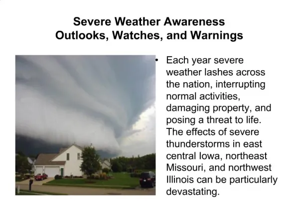
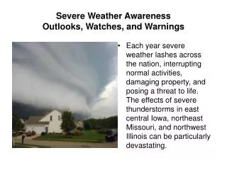
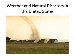
Severe and Hazardous Weather In the U.S.A. • Tropical cyclone (depression, storm, hurricane- typhoon winds, rain, storm surge) • Thunderstorm (hail, strong winds, intense local rain, lightning, tornadoes, downbursts) • Winter Storm (blizzard, freezing rain, extreme cold) • Wildfire (forest, grasslands) • Strong winds from intense cyclonic systems (damaging winds; blowing dust; ground blizzard) • Flooding (flash; widespread) • Stagnant situation (air quality - smog; in summer, extreme heat) • Obscurants - Fog, smoke, dust, blowing snow
Flash Floods - #1 Weather-Related Killer in US • Cheyenne, Wyoming – 1985: 12 fatalities, $61M in damage • Shadyside, Ohio – 1990: 26 fatalities, $8M in damage • Dallas, Texas – 1995: 16 fatalities, $1B, damage • Ft. Collins, Colorado – 1997: 5 fatalities, $100M in damage
Large Hail • Threat to property, agriculture
Tornadoes Moore, Oklahoma, 3 May 1999
Tornadoes Lakeview, Texas, 19 April 1977
Severe Weather Warning Operations Began in 1953 – What took so long? • General forecasts since 1880s, but not specific forecasts, warnings • Concerns re specific storm warnings • Panic! • Technical feasibility • Credibility • Effort required – cost/benefit • 1953 – Waco, TX; Flint, MI; Worchester, MA – Congress directs USWB to begin storm warning services
Continuing Evolution • 1950s: First operations – built on WW II technology • Located Kansas City due to communications • Combined USWB and AWS operation • Combined operations (SELS) and research (NSSP) • Primitive radars – WSR-3 • 1960s: Mature operations • National Severe Storms Laboratory (NSSL: Norman, Oklahoma) • National Severe Storms Forecast Center (NSSFC; Kansas City) -- blended with aviation weather forecasting • First national weather radar network – WSR-57
1980s-1990s: Re-invention • 1980s: Restructuring 1 • Deployment of new radar system -- WSR-88D • Consolidation of NWS Forecast Offices around radars • Co-location of selected offices on university campuses 1990s: Restructuring 2 • Move of operations to Norman, OK Storm Prediction Center (aviation operations to new Aviation Weather Center) • Rejoining of operations with research importance of research, timely transfer to operations • 2000s: Continuing upgrades • Radar – dual polarization retrofit • Local mesoscale models
Why The Strong Focus On Tornadoes? • Major hazard over most of the U.S. east of the Rocky Mountains • Potential for major loss of life • Some events produce $1B+ in property losses • Scientific and Technical Challenge • Continually tests overall severe weather warning systems • Pushes development of technology, techniques that then has other applications • Political Realities
1998 Tornadoes(most fatalities since 1992) • 1254 tornadoes in 48 contiguous states • 129 fatalities. (67 in mobile homes) • February: “Night of the Tornadoes,” Orlando, FL – 42 deaths, 260 injured • April: VA, MI, TE, GA - 50 fatalities, 272 injuries
May 3, 1999 Tornado Outbreak in Oklahoma • 38 dead, 748 injured, $1 Billion damage • NWS warning based on NEXRAD detection of a tropospheric mesocyclone saved est. 600 lives • UMASS/UOklahoma radar captures the tornado on the ground, yielding highest spatial resolution images ever with W-band radar
What Is A Severe Weather Watch? • A severe weather watch defines a region where a specific form of severe weather is possible in the next several hours. It describes a general region, typically part of a state, the type of weather expected, the period in which the weather is likely to be severe, and provides reminders regarding appropriate actions. • Issued by the Storm Prediction Center (Tropical Prediction Center in the case of tropical storms) as a forecast based on model output, forecaster judgment of the evolution of the situation • It does not mean that the occurrence of severe weather is imminent, but that is it possible • It is a first alert to the public to be watchful and prepared to go to appropriate shelter if the weather turns severe or a warning is issued.
Simplified Example Of A Watch Statement 11 am Severe thunderstorms with large hail and damaging winds are expected in your area between 2 pm and 9 pm today
SEL9 URGENT - IMMEDIATE BROADCAST REQUESTED SEVERE THUNDERSTORM WATCH NUMBER 229 NWS STORM PREDICTION CENTER NORMAN OK 1210 AM CDT SUN MAY 4 2003 THE NWS STORM PREDICTION CENTER HAS ISSUED A SEVERE THUNDERSTORM WATCH FOR PORTIONS OF SOUTHWEST IOWA NORTHEAST KANSAS NORTHWEST MISSOURI EASTERN NEBRASKA EFFECTIVE THIS SUNDAY MORNING FROM 1210 AM UNTIL 600 AM CDT. HAIL TO 2 INCHES IN DIAMETER...THUNDERSTORM WIND GUSTS TO 55 MPH...AND DANGEROUS LIGHTNING ARE POSSIBLE IN THESE AREAS. THE SEVERE THUNDERSTORM WATCH AREA IS ALONG AND 105 STATUTE MILES EAST AND WEST OF A LINE FROM 65 MILES NORTH OF OMAHA NEBRASKA TO 40 MILES EAST SOUTHEAST OF EMPORIA KANSAS. REMEMBER...A SEVERE THUNDERSTORM WATCH MEANS CONDITIONS ARE FAVORABLE FOR SEVERE THUNDERSTORMS IN AND CLOSE TO THE WATCH AREA. PERSONS IN THESE AREAS SHOULD BE ON THE LOOKOUT FOR THREATENING WEATHER CONDITIONS AND LISTEN FOR LATER STATEMENTS AND POSSIBLE WARNINGS. SEVERE THUNDERSTORMS CAN AND OCCASIONALLY DO PRODUCE TORNADOES.
National Centers for Environmental Prediction NWS Forecast Office USERS
Storm Prediction Center (SPC) The SPC is the element of the National Weather Service/National Centers for Environmental Prediction charged with providing timely and accurate forecasts and watches for severe weather over the contiguous United States, including thunderstorms/tornadoes, heavy rain, heavy snow, and fire weather events. The SPC produces a suite of products to relay forecasts of organized severe weather as much as three days ahead of time, and continually refines the forecast up until the event has concluded. All products issued by the Storm Prediction Center are available on the World Wide Web. Its products are commonly used by National Weather Service offices, emergency managers, TV and radio meteorologists, private weather forecasting companies, the aviation industry, storm spotters, agriculture, educational institutions and many other groups.
ZCZC MKCWWAMKC ALL 030300;370,1005 311,1015 311,1042 370,1035; WWUS8 KMKC 030013 MKC WW-A 030013 NMZ000-TXZ000-OKZ000-0300300- STATUS REPORT ON WW NUMBER 361 AND 362 IN WW 361 THE THREAT OF SEVERE WEATHER CONTINUES TO THE EAST OF A LINE FROM 50 SW WINK TO 30 NE CNM TO 40 E ROW TO 65 W CVS. IN WW 362...CONTINUE WW. TORNADO WATCH WILL LIKELY BE REQUIRED FARTHER EAST INTO THE ERN TX PANHANDLE AND WRN TX AND OK BY 02Z. NUMEROUS SUPERCELLS CONTINUE DEVELOPING OVER THE SRN HIGH PLAINS EAST OF THE DRYLINE IN AN AXIS THAT EXTENDS FROM NEAR WINK TX TO NEAR CLAYTON NM. NUMEROUS REPORTS OF BASEBALL HAIL HAVE BEEN RECEIVED. WV IMAGERY SHOWS SHORTWAVE LIFTING NEWD THROUGH UT AND WRN CO. DEEP LAYER SHEAR PROFILES HAVE INCREASED TO 60 KT AS MID LEVEL SPEED MAX ON THE SRN PERIPHERY OF SHORTWAVE LIFTS NEWD TOWARD THE SRN PLAINS. INDIVIDUAL CELLS WERE MOVING NEWD AT AROUND 35 KT. INCREASING LOW LEVEL INFLOW ASSOCIATED WITH DEVELOPING LOW LEVEL JET WILL SUPPORT CONTINUED EWD DEVELOPMENT INTO THE EVENING. INCREASING STORM RELATIVE FLOW AND SHEAR PROFILES SUGGEST THREAT FOR SUPERCELLS WITH LARGE HAIL...DAMAGING WIND AND ISOLATED TORNADOES WILL CONTINUE AS ACTIVITY DEVELOPS EWD INTO INSTABILITY AXIS ACROSS THE TX AND OK PANHANDLES WHERE SBCAPES ARE AS HIGH AS 5000 J/KG. ..DIAL.. 06/02/99 NNNN
ZCZC MKCWWAMKC ALL 040300;335,0993 360,0993 360,0961 335,0962; WWUS8 KMKC 032333 MKC WW-A 032333 OKZ000-040200- STATUS REPORT ON WW NUMBER 195 CLUSTER OF INTENSE THUNDERSTORMS...INCLUDING STRONG TORNADIC SUPERCELLS WEST/SOUTHWEST OF OKLAHOMA CITY AREA IS ONGOING. STRONG AND INTENSIFYING DIVERGENT UPPER FLOW FIELD...ENHANCED BY MID/UPPER JET DIGGING ACROSS THE SOUTHERN ROCKIES...WILL CONTINUE TO SUPPORT EVOLUTION INTO LARGER SEVERE CONVECTIVE SYSTEM...AHEAD OF DRY LINE ...THROUGH THE EVENING HOURS. GIVEN ONGOING AND EXPECTED TRENDS... WW MAY BE REPLACED WITH NEW WW INCLUDING NORTHERN OKLAHOMA AND PARTS OF NORTH CENTRAL TEXAS WITHIN THE NEXT HOUR OR SO. ..KERR.. 05/03/99 NNNN
What Is A Severe Weather Warning? • A severe weather warning indicates that severe weather is occurring or is imminent for specific region. It describes the specific region being threatened, evidence for the occurrence of the severe weather, direction and speed of movement, and likely duration. Rapidly updated as necessary • Issued by the local National Weather Service Forecast Offices minutes to a few hours in advance of the occurrence. • Usually based on actual observations: spotters, law enforcement, or radar. • It is an alert to the public that immediate action is required. • Can be issued without a preceding Watch • Goal: No surprises to the public!
Simplified Example Of A Warning Statement 3:35 pm Spotters report a severe thunderstorm with large hail and damaging winds near your vicinity, moving to the NE at 50 km/hour. Take shelter immediately, and remain in shelter for next 30 minutes.
WFUS51 KCLE 122345 TORCLE OHC169-130030- BULLETIN - EAS ACTIVATION REQUESTED TORNADO WARNING NATIONAL WEATHER SERVICE CLEVELAND OH 644 PM EST WED NOV 12 2003 THE NATIONAL WEATHER SERVICE IN CLEVELAND HAS ISSUED A * TORNADO WARNING FOR... WAYNE COUNTY IN NORTHEAST OHIO... * UNTIL 730 PM EST * AT 644 PM EST NATIONAL WEATHER SERVICE DOPPLER RADAR INDICATED A SEVERE THUNDERSTORM CAPABLE OF PRODUCING A TORNADO 10 MILES WEST OF WOOSTER...MOVING EAST AT 50 MPH. * SOME LOCATIONS NEAR THE PATH OF THIS STORM INCLUDE... DALTON DOYLESTOWN ORRVILLE WOOSTER LAT...LON 4092 8199 4095 8177 4098 8165 4075 8165 4072 8212 4089 8212 $$
WFUS54 KHGX 171506 TORHOU TXC321-481-171545- BULLETIN - EAS ACTIVATION REQUESTED TORNADO WARNING NATIONAL WEATHER SERVICE HOUSTON/GALVESTON TX 905 AM CST MON NOV 17 2003 THE NATIONAL WEATHER SERVICE IN LEAGUE CITY HAS ISSUED A * TORNADO WARNING FOR... WHARTON COUNTY IN SOUTHEAST TEXAS MATAGORDA COUNTY IN SOUTHEAST TEXAS * UNTIL 945 AM CST * AT 900 AM CST...NATIONAL WEATHER SERVICE DOPPLER RADAR INDICATED A SEVERE THUNDERSTORM CAPABLE OF PRODUCING A TORNADO 8 MILES WEST OF MARKHAM...OR ABOUT 14 MILES WEST OF BAY CITY...MOVING NORTHEAST AT 20 MPH. * LOCATIONS IN THE PATH OF THE SEVERE THUNDERSTORM INCLUDE... MARKHAM AND BOLING THE SAFEST PLACE TO BE DURING A TORNADO IS IN THE INTERIOR HALLWAY OR ROOM SUCH AS A CLOSET ON THE LOWEST LEVEL OF A STURDY BUILDING. USE BLANKETS OR PILLOWS TO COVER YOUR BODY AND ALWAYS STAY AWAY FROM WINDOWS. IF IN MOBILE HOMES OR VEHICLES...EVACUATE THEM AND GET INSIDE A SUBSTANTIAL SHELTER. IF NO SHELTER IS AVAILABLE...LIE FLAT IN THE NEAREST DITCH OR OTHER LOW SPOT AND COVER YOUR HEAD WITH YOUR HANDS. PLEASE REPORT SEVERE WEATHER TO THE COUNTY SHERIFF...LOCAL POLICE... OR DEPARTMENT OF PUBLIC SAFETY. THEY WILL RELAY YOUR REPORT TO THE NATIONAL WEATHER SERVICE. A TORNADO WATCH REMAINS IN EFFECT UNTIL 100 PM CST MONDAY AFTERNOON FOR SOUTHEAST TEXAS. LAT...LON 2901 9631 2888 9617 2912 9586 2925 9602 $$
SPOTTERS NWS Forecast Office USERS
Oklahoma Weather Center 2002 Storm Spotter Talk ScheduleCalendarTable National Weather Service Weather Forecast Office
National Weather ServiceForecast Office – Key Personnel • Science Operations Officer (1) – training, review and assessment of severe warning team, infusion of new technology, techniques • Warning Coordination Meteorologist (1) – training of users (state, county, city emergency management personnel) and spotters (law enforcement, fire fighters, amateur radio clubs) • Journeyman/Lead Forecasters (3 to 5) – leads severe weather warning team; decides when conditions merit issuance of a warning
Key to Severe Weather Monitoring: The National Radar Network • WSR-88D Doppler Weather Surveillance Radar • A “national network”, but locally operated
NEXRAD: WSR-88D 8.5 meter antenna; ~1o beam width 500 kW transmitter Volume scanning strategy Reflectively and Doppler field outputs 138 installations across US
NEXRAD THUNDERSTORM (SUPERCELL) IMAGERY Hook Echoes and Vortex Doppler “Couplets” reliably indicate the presence of mesocyclones in the troposphere Image/Text/Data from the University of Illinois WW2010 Project.
Other Radars Used InSevere Weather Warning • TWDR • FAA-controlled, focused on wind shear detection • Same technology as WSR-88D, but 5 cm • Commercial radars, mainly television
Types of Watches/Warnings Flood / Flash Flood Severe Thunderstorm Tornado Tropical Storm Hurricane Winter Storm Excessive Heat
Radar => detects mesocyclones • Probability of detection ~70%; • Average warning time is ~11 minutes • False alarm problem is significant since only ~30% of mesocyclones produce tornadoes (= intense columnar vortex in contact with the ground) • Situation best for largest, most long-lived events, which pose greatest threat • Situation poorest for small, short-lived events
What Is A Severe Weather Advisory? • A severe weather advisory provides the public information on a weather condition that may be hazardous to certain portions of the population or may cause great inconvenience. An advisory defines a region where a specific form of severe weather is possible in the next several hours. It describes a general region, typically part of a state, the type of weather expected, the period in which the weather is likely to be present, and provides reminders regarding appropriate actions. • Issued by the Storm Prediction Center (Tropical Prediction Center in the case of tropical storms) or the local National Weather Service Forecast Office. • Often used where conditions are threatening, but where established severe weather thresholds are not likely to be crossed.
A Few Types Of Advisories Fog Heavy Snow High Wind/High Profile Vehicle
The Future • Dual Polarization Retrofit to WSR-88D • Hydrology flood warnings • Ground clutter removal • Improved scanning strategies • GIS-based products • Development of a centralized (national? regional?) radar network, including FAA, possibly commercial radars national/regional high resolution composite, mosaics; adaptive operational strategies
The Future • Fill in the boundary layer – dense network of small, inexpensive radars on cell phone towers • Continuously updating model-based forecasts, out to 30, 60, 90 minutes, with update rates of a few minutes • Very fast local computing • Forecaster has access to seamless past, current, future on a “smart” decision support system • Warn on prediction
Spread of State-/Region-Based Mesonetworks • Conventional surface network + Oklahoma Mesonet + DoEnergy ARM Site and network + special networks
Continually ImprovingStorm Scale Models • Created the world’s first storm-scale numerical forecast system (ARPS) – now used operationally by American Airlines and others (FAA, NWS) • Direct, 4D Var assimilation of radar data D/FW Storms on NEXRAD Radar 6-hour Forecast