Download
1 / 10
130 likes | 408 Vues
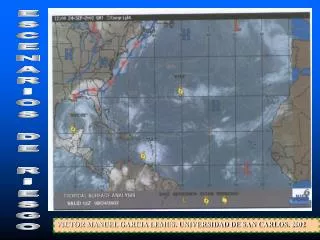
ESCENARIOS DE RIESGO. VICTOR MANUEL GARCIA LEMUS. UNIVERSIDAD DE SAN CARLOS. 2002. PROYECTO: MANEJO DE RIESGOS Y PREVENCION DE DESASTRES VNU- USAC. ESCENARIO DE RIESGO -ISIDORE 1123-09-2002

E N D
ESCENARIOS DE RIESGO VICTOR MANUEL GARCIA LEMUS. UNIVERSIDAD DE SAN CARLOS. 2002
PROYECTO: MANEJO DE RIESGOS Y PREVENCION DE DESASTRES VNU- USAC
ESCENARIO DE RIESGO -ISIDORE 1123-09-2002 La trayectoria del Huracán Isidoro (hoy Tormenta Tropical) ha sido errática y tomando un rumbo Suroeste inesperado desde la isla de Cuba hacia la Península de Yucatán. Para las 12 horas del día de hoy (-6:00 GMT), sus vientos se debilitaron amenos de 118 km/h al ubicarse el "ojo" en tierra firme pasando a ser catalogado como Tormenta Tropical. Actualmente mantiene una trayectoria con rumbo este, aunque teóricamente se esperaría que tome rumbo noroeste entrando al Golfo de México donde recobraría fuerza; su desplazamiento es a una velocidad menor a 10 km/hora. Considerando lo anterior, el antecedente de lluvias del fín de semana que se muestra en el mapa siguiente y que a pesar de estar catalogado como Tormenta Tropical, continua arrastrando humedad desde el Pacífico, se espera que los máximos de Precipitación se continúen dando en la región de la bocacosta del Pacífico, sobre todo en horas de la tarde, lo cual puede implicar nuevas inundaciones o agravar las ya existentes en la vertiente del Pacífico para la noche de hoy. Se espera que estas condiciones prevalezcan durante las próximas a 12 -18 horas. La zona de Petén Gerencia de Gestion para la Reducción de Riesgo Secretaria Ejecutiva CONRED ISIDORE 1 / 23-09-2002
ESCENARIOS DE RIESGO: Estudio de variables • Descripción del pasado. • Caracterizacion de la realidad. • Análisis de tendencias y contingencias. • Predicción del comportamiento. • Vision crítica del futuro. • Neutralizar, incidir, modificar.
OBJETIVOS: • Caracterizar actores y recursos. • Elaborar cronograma eventos previos. • Caracterizar riesgo (mapas). • Focalizar grupos e infraestructura en riesgo. • Visión global roles y dinamica social. • Prioridades y ruta critica de intervención.
EL ESCENARIO ACTORES ESPACIOS RECURSOS ESCENOGRAFICOS ROLES Y MENSAJES LIBRETO DESENLACE
1. ESCENARIO ACTUAL • REVISION DOCUMENTAL. • INVENTARIO DE DESASTRES. • CARAC. Y MAPEO GENERAL. • MAPA DE RIESGOS. • MAPA DE RECURSOS.
2. ANALISIS DE RIESGO: • CARACTTERIZAR AMENAZAS. • CARACTERIZAR VULNERABILIDAD. • ANALISIS SITUACIONAL. • ANALISIS DE TENDENCIA Y RUTA DE INTERVENCIÓN.
FORTALECER UNIDAD TECNICA MUNICIPAL.(EQUIPOS MULTIPROFESIONALES). CAPACITACION. ORGANIZACIÓN SOCIAL. REDUCCION DE FACTORES DE RIESGO. NUESTRO MODELO:
FUNCION POLITICA: =ORGANIZACIÓN LOCAL. COMRED Y COLRED. =CULTURA DE TRABAJO PARTICIPATIVO. =NEGOCIACION Y CONCENSO. =INFORMACION OPORTUNA PARA LA TOMA DE DECISIONES. FUNCION JURIDICA: =REGULACION. (ORDENAMIENTO TERRITORIAL Y USO DE RECURSOS, INCENTIVOS Y PENAS. FUNCION FINANCIERA: =SISTEMA DE ASMINISTRACION PRESUPUESTAL Y AUTONOMIA FINANCIERA. FUNCION ADMINISTRATIVA: =SISTEMA DE APOYO. CAPACIDADES LOCALES: