Digital BAS Workshop
2. Overview. What is the MAF/TIGER Database?What is included in the Digital BAS package?What is the difference between Digital BAS and MTPS?What are some tips for updating the BAS materials digitally?What types of changes can I make digitally?How do I make boundary changes in MTPS or through Digital BAS?How do I return my digital submission to the Census Bureau?MTPS and Digital BAS Demo.

Digital BAS Workshop
E N D
Presentation Transcript
1. 1 Digital BAS Workshop
Legal Areas Team
U.S. Census Bureau
2. 2 Overview What is the MAF/TIGER Database?
What is included in the Digital BAS package?
What is the difference between Digital BAS and MTPS?
What are some tips for updating the BAS materials digitally?
What types of changes can I make digitally?
How do I make boundary changes in MTPS or through Digital BAS?
How do I return my digital submission to the Census Bureau?
MTPS and Digital BAS Demo
3. 3 What is the MAF/TIGER Database?
4. 4 MAF/TIGER Database Master Address File / Topologically Integrated Geographic Encoding and Referencing (MAF/TIGER Database)
Rather than having one layer for each feature class all information is stored in one file
Database is constructed of nodes, edges, and faces
Each edge can represent the boundary for multiple geographies
An edge can be a place, county, tract, school district, voting district boundary, etc.
Making a change to a place boundary can affect other geography
5. 5
6. 6 What is included in the
Digital BAS package?
7. 7 Package Materials Letter and Form
You do not need to fill out the paper form when responding digitally, however it does contain your username for MTPS
Username is always �BAS�
MAF/TIGER Partnership Software CD
Data and Respondent Guide CD
Contains shapefiles for use with either method
Contains respondent guides for each method
No Change postcard
8. 8 What is the difference between Digital BAS and MTPS?
9. 9 Digital BAS In Digital BAS, participants use their own GIS to create �change polygons� of the difference between their boundaries and ours and enter the appropriate information in the attribute table
We send out ESRI shapefiles, but any GIS that can read/convert shapefiles may be used
It is important to read the respondent guide carefully to make sure you include all required information
10. 10 MAF/TIGER Partnership Software (MTPS) In MTPS, participants use our provided software (created by Caliper) to create the �change polygons�
The software helps/forces the user to include the required information about the changes
The software converts the shapefiles to Maptitude format and back to shapefiles, and zips all of the output files together for you
MTPS is appropriate for users who are not experienced in GIS or do not have their own GIS software
11. 11 What are some tips for updating the BAS materials digitally?
12. 12 Digital Update Tips We cannot accept a local GIS file to �replace� our existing boundary
We must have legal documentation and effective dates for all legal changes
We must keep record of all changes made for reference purposes
Topologically integrated database
Include all appropriate legal documentation and effective dates
Snap to existing census geography where possible
Use existing census roads, rail, and hydro wherever possible (if our river and your river differ spatially by 10 feet, snap to our river)
Exceptions exist where population is affected
13. 13 What types of changes can I make digitally?
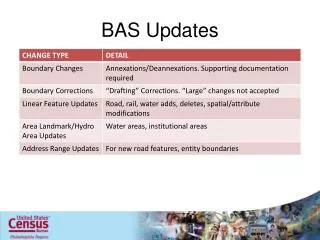
14. 14 Annexations and Deannexations Legal documentation (effective date and ordinance/resolution number) must be included in the attribute table for all annexations and deannexations.
If you have a very large change polygon, or one that is not contiguous with the rest of your boundary, this is likely an annexation or deannexation, although it may have occurred in a previous year. We still require documentation for these changes.
15. 15 Boundary Corrections Boundary corrections are changes that are not annexations or deannexations, although they may be fixing the depiction of a previous annexation or deannexation.
Boundary corrections do not require documentation � they do require a relate value of �IN� or �OUT� denoting whether the polygon should be added to the place/county or taken out of the place/county.
If a new annexation does not quite align with the old boundary because of an incorrectly depicted previous annexation, you may adjust the new annexation to match up, or create a boundary change polygon for the area in between.
16. 16 Geographic Corridors An area that only includes road surface and right-of-way and does not contain any structures addressed to either side of the road is a geographic corridor.
Without additional information from the BAS participant, the Census Bureau will geocode addresses based upon the centerline.
If this coding would result in addresses being assigned to the wrong entity, we recommend the creation of a geographic corridor.
There are two types of geographic corridors
Road through unincorporated space
Road through incorporated space
17. 17 Geographic Corridors
18. 18 Geographic Corridors
19. 19 Geographic Offset A geographic offset is an area claimed by an entity that is only on one side of the road and does not include any structures addressed to that side of the road.
If your boundary is not coincident with the centerline but follows the parcel line, and the addresses along the road should be in your jurisdiction, you need to report a geographic offset or snap the boundary to the centerline.
Using one of these techniques insures that the residential structures will be assigned to the correct geography.
Again, without additional information, the census bureau will code the addresses to the centerline of the road.
While the census bureau recognizes that most local governments do use parcels to map their boundaries, the census bureau would ultimately prefer that participants use the centerlines to map their boundaries. This ensures that the correct population counts are assigned to the correct geographies�.etc etc.Again, without additional information, the census bureau will code the addresses to the centerline of the road.
While the census bureau recognizes that most local governments do use parcels to map their boundaries, the census bureau would ultimately prefer that participants use the centerlines to map their boundaries. This ensures that the correct population counts are assigned to the correct geographies�.etc etc.
20. 20 Geographic Offsets and Corridors through Incorporated Places
21. 21 How do I make boundary changes in MTPS or though Digital BAS?
22. 22 Change Polygons in MTPS In MTPS, you can only select whole faces or groups of faces in order to form a change polygon.
It is often necessary to insert lines using the line editing toolbar to break up existing faces into the smaller faces that you need. If these lines do not represent roads or other visible features, assign them an MTFCC value of �P0001� (non-visible boundary).
If many adjacent faces are all part of the same annexation or boundary correction, you should select them all together to make one large polygon. However, you normally do not want to select non-adjacent faces as part of the same polygon.
23. 23 Change Polygons in Digital BAS There is an example process in the Appendix of the respondent guide describing how to create polygons based on existing lines. This is good when your boundary is mostly accurate and you only need to report a few annexation or deannexations.
If you have not participated in BAS digitally before, there may be many differences between our boundary and yours, and it may be easier to use a symmetrical difference operation or another GIS comparison. It is preferable that you compare to an overall boundary rather than parcel data when performing this operation. It is also important that you review all of the change polygons created and include the necessary attribute information, as well as potentially delete some unneeded polygons.
24. 24 How do I return my digital submission to the Census Bureau?
25. 25 Returning Data to the Census Bureau Our FTP site and instructions for submitting files to us are in the respondent guides.
If you are using MTPS, the software includes a lot of extraneous files and the return zip file can be very large. If you are having problems uploading it and wish to make it smaller, you can include only those files whose names begin with �BAS10� � we don�t need the others to process your changes.
26. 26 Demonstration of MAF/TIGER Partnership Software and Digital BAS
27. 27 Contact Information Direct Contact Information
Mike Clements
Phone: 301-763-9124
Email: michael.j.clements@census.gov
Diane Snediker
Phone: 301-763-8960
Email: diane.snediker@census.gov
Nathan Jones
Phone: 301-763-9095
Email: nathan.jones@census.gov
Shawn Smith
Phone: 812-218-3152
Email: shawn.d.smith@census.gov
Chris Flaherty
Phone: 812-218-4356
Email: chris.flaherty@census.gov