Enhancing Convective Event Forecasting During the North American Monsoon Season
This project aims to evaluate a suite of convective initiation (CI) products to improve forecasts and detection of hazardous convective events during the North American monsoon season. Utilizing unique satellite products from NASA SPoRT and the University of Wisconsin, in conjunction with NSSL WRF CI products, we aim to enhance the operational capabilities of the Albuquerque National Weather Service. Collaboration efforts include regular meetings and special study periods to develop hybrid satellite products that can effectively identify key features for better prediction of convective storms and associated flooding.

Enhancing Convective Event Forecasting During the North American Monsoon Season
E N D
Presentation Transcript
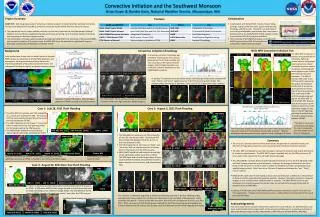
Project Summary • OBJECTIVE: Test the growing suite of convective initiation products to determine their potential to improve forecasts and detection of hazardous convective events during the North American monsoon season. • The operational use of unique satellite products is particularly important for the Albuquerque National Weather Service office by supplementing data void areas, enhancing current satellite analysis techniques, and improving our decision support services. • The combination of unique satellite products provided by NASA SPoRT, the University of Wisconsin/CIMMS, and convective initiation (CI) products from the NSSL WRF, have the potential to significantly improve detection and forecasts of hazardous convective events. • Collaboration • Collaboration with NASA SPoRT includes frequent blog postings, regular conference calls, special study periods, meetings, and office visits. This work is an extension of our existing collaboration and assesses their most recent development of the GOES/MODIS hybrid satellite product as part of the GOES-R Proving Ground effort. • The University of WI/CIMMS produces a CI product for AWIPS as part of the GOES-R Proving Ground Convective Initiation Nowcast project. Products UW CI 1900Z Hybrid IR 2015Z Hybrid IR 2002Z MODIS IR 2006Z UW CI 1745Z UW CI 1800Z 1912Z FFW 1937Z Hybrid 1915Z Hybrid 1932Z Hybrid 1945Z AFTER BEFORE MODIS Vis 2006Z Reflectivity 1912Z NSSL dBZ Test 21Z Reflectivity 2012Z NSSL WRF Convective Initiation Test Convective Initiation Climatology Background Local studies have shown that the identification of elevated PWAT values, the advection of strong PWAT gradients, and atmospheric forcing mechanisms are key features for improving prediction of hazardous convective events and subsequent flooding during the southwest monsoon season. The NSSL WRF includes a CI product using thresholds for reflectivity, lightning, vertical motion and graupel. Local studies have shown during the monsoon season convection climatologically favors higher terrain initially then spreads into lower elevations. The NSSL CI product adds value to our POP forecast by improving the spatial and temporaldistribution of convective development. The initial area of storm development over north central NM verified exceptionally well against the NSSL WRF CI and the NWS POP forecast.Note the increase in storminitiations with time on the reflectivity images. Purple dots on the GFE lightning grid show the distribution of cloud to ground strikes between 00-06Z. A convective initiation climatology was created by examining the first cumulus development on the hybrid visible and -31C cloud top on the hybrid infrared imagery, the first lightning strike, and convective initiation detections on the UW/CIMMS CI product. http://nasasport.wordpress.com/ http://cimss.ssec.wisc.edu/~jordang/awips/ci/ Convective Initiation and the Southwest MonsoonBrian Guyer & Deirdre Kann, National Weather Service, Albuquerque, NM 8/13/11 18Z 8/13/11 21Z 8/14/11 02Z NSSL dBZ Test A “perfect” CI detection as shown below shows a developing thunderstorm complex with “pre”, “likely”, and “occur” signatures prior to the first cloud to ground strikes. This example shows 60 minutes of lead time. Only 9 out of 515 CI detections were “perfect”. Hybrid Vis 7/22/11 1745Z Hybrid Vis 7/22/11 1815Z WaterVapor 8/13/11 0815Z TPW 8/13/11 0815Z NWS POP Grid Pre CI 1930Z Likely CI 1941Z Occur CI 1946Z CG Strikes 2030Z The NASA SPoRT hybrid satellite product is a composite of baseline GOES and high resolution MODIS imagery. Blue bars indicate FFW events. Note strongest gradients of PWAT coincide with several events. Hybrid IR 7/7/11 1731Z Hybrid IR 7/7/11 1715Z 7/23/11 Embudo Arroyo 8/13/11 Reflectivity Case 2: August 3, 2011 Flash Flooding Case 1: July 28, 2011 Flash Flooding FFW 2055Z • The NSSL dBZ test indicates a 60-70% probability of CI at 21Z over northeastern NM. The forecast POP has narrowed the greatest threat for storms to this area between 18-00Z. • The UW CI detection at 19Z shows CI “occurring” with no lead time for the first lightning strikes but 95 minutes before the FFW issuance. • The NASA SPoRT hybrid IR evolution below depicts significantly colder cloud tops at 1932Z. GFE Lightning Grid *The NSSL CI score was computed by averaging the max CI probability over the domain for all three CI categories. The chart above displays the distribution of short-fused hazard products versus the number of CI detections and the NSSL CI score*. Note the correlation between product count, higher CI score, and higher CI count. Reflectivity 2054Z • The NSSL dBZ test indicates a 60-70% probability of CI at 20Z over western NM. The forecast POP has narrowed the greatest threat for storms to this area between 18-00Z. • The UW CI detection at 17Z shows CI “likely” and “occurring” with no lead time to the first strikes but 157 minutes prior to the FFW issuance. • NASA SPoRT hybrid infrared evolution to the right shows significantly colder cloud tops at 1932Z. This 500-meter hybrid visible image shows sharper contrast between individual thunderstorm towers, better depiction of cirrus anvils, and overshooting tops. Summary • The various CI products examined here demonstrate the potential to improve forecasts and detection of hazardous convective events associated with the North American monsoon. • The NSSL WRF CI probabilities can help forecasters improve the temporal and spatial distribution of convective development. The NSSL WRF output is available only for the 00Z cycle out to 36 hours and is most relevant for the overnight forecast package. • The UW/CIMMS CI product demonstrated substantial lead time prior to the first lightning strikes and flash flooding events on several occasions. However, the average lead time for the entire study period was only 4.1 minutes which is within the limitations of radar sampling delay and satellite latency effects. Only 9 out of the 515 total CI detections followed the “pre”, “likely”, “occur” pattern. • NASA SPoRT visible and infrared hybrid products increase forecaster confidence on the presence of deep convection and potential hazardous weather. However, the higher resolution composite imagery is only available when a MODIS swath is available. The NASA SPoRT team has also developed a CI product however the domain does not yet extend far enough to the west for operational use at NWS ABQ. • Latency of SPoRT hybrid and UW/CIMMS satellite products remains an issue for very near real time applications. However these products serve as a highly effective training tool for the use of future GOES-R data. Folsom, NM POP Forecast 18-00Z NSSL dBZ Test 20Z POP Forecast 18-00Z Note the more accurate location of the colder cloud tops versus the lightning maximums at 1932Z compared to the 1915Z and 1945Z images. Flash flooding on the Dry Cimarron River. Hybrid IR 1915Z Hybrid IR 1932Z Hybrid IR 1945Z Case 3: August 22, 2011 Burn Scar Flash Flooding Hybrid IR 1915Z Hybrid IR 1932Z Hybrid IR 1945Z UW CI 1830Z UW CI 1700Z FFW Hybrid Vis 1915Z Hybrid Vis 1932Z Hybrid Vis 1945Z A “likely” CI detection at 1745Z occurred 87 minutes before the FFW issuance at 1912Z. A 500-meter MODIS visible image showed an initial convective band at 1832Z spreading out on outflows through 2006Z. The 2km MODIS infrared image at 2006Z showed cold cloud tops nearly 1 hour after the FFW issuance. NSSL dBZ Test 19Z MODIS Vis 1832 Z Significant flash flooding was observed in Peralta Canyon. This “perfect” CI detection beginning at 1830Z provided long lead time to the first lightning strikes and significant heavy rainfall over the Manzano Mountains to the southeast of Albuquerque. Radar estimates indicated 4 - 5 inches of rain with this storm which fell over and adjacent to a burn scar from 2010. While no reports of flash flooding were received the flash flood warning was preceded by the initial CI detection by 102 minutes and a colder cloud top detection on the hybrid image by 40 minutes. Acknowledgements This work would not be possible without the support of Dr. Gary Jedlovec, Dr. Geoffrey Stano, and Kevin Fuell of NASA SPoRT, Jordan Gerth of the University of Wisconsin / Cooperative Institute for Mesoscale Meteorological Studies, Matt Bunkers, NWS RAP, and Annette Mokry, NWS ABQ. UW CI 1830Z UW CI 1846Z UW CI 1853Z