Download
1 / 50
500 likes | 549 Vues
Embark on a visual journey exploring the diverse physical features from the Coastal Plain to the Trans-Jordan Plateau. Delve into the major regions, smaller geographic elements, and significant water bodies, captured in stunning photographs.

E N D
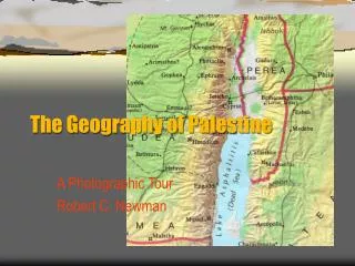
The Geography of Palestine A Photographic Tour Robert C. Newman
Physical Features of Palestine • Major Regions • Going from West to East • Some Smaller Geographic Features • Going from North to South • The Major Bodies of Water • Seas, lakes, rivers
Major Regions West to East • Coastal Plain - 1 • Shephelah - 2 • Hill Country - 3 • Rift Valley - 4 • Trans-Jordan Plateau - 5 5 4 3 2 1 5 3 2 1 4
Coastal Plain • Low, flat • Fertile where not too salty or sandy • Easily invaded • Terrain pretty smooth • Open to South • Reached from North thru passes Coastal Plain
Shephelah “Lowlands” • Somewhat higher than coastal plain • Lower than Hill Country • Rolling terrain • Travel typically along valleys • Relatively easy to invade Shephelah
Shephelah “Lowlands” Beth Shemesh
Shephelah “Lowlands” Shephelah from Azekah
Hill Country • Sharp hills, V-shaped valleys • Resembles West Virginia • Travel along ridges • Difficult to invade • Agriculture uses terraces • Rainfall good W of ridge, poor to E of ridge Hill Country
Hill Country Kefar Ezyon
Rift Valley • A geologic fault (Graben) • Extends S into Africa, N into Syria • Wide U-shaped valley • Jordan R has its own valley in middle • Climate hot & dry • To grow crops, must use irrigation Rift Valley
Rift Valley Rift Valley from Belvoir
Rift Valley In Rift Valley North of Jericho
Trans-Jordan Plateau • A flat tableland • Higher than Hill Country • Relatively well-watered at Western edge • Quickly becomes desert as one moves Eastward T-J Plateau
Trans-Jordan Plateau Fertile soil on T-J Plateau
Trans-Jordan Plateau On T-J Plateau Looking SW Into Rift Valley
Smaller Geographical Features A • Mount Hermon - A • Galillee & Mt. Tabor - B • Jezreel Valley - C • Mount Carmel - D • Wilderness of Judea - E • The Negev - F B D C E F
Mount Hermon • Highest peak in Palestine area • Elevation over 9,000 ft • Southernmost peak of the Anti-Lebanon range • Peak is generally snow-covered all year
Galilee & Mount Tabor • Hilly region, N extension of Hill Country • Best-watered area in Palestine, similar to Eastern United States • N is higher, S lower • Reasonably cool except around Sea of Galilee • Mt Tabor (1900 ft) is an isolated peak
Galilee Galilee & Horns Of Hattin from Mt Arbel
Jezreel Valley • An E-W valley connecting coast with Jordan valley • Separates Samaria from Galilee • Easiest passage from Rift Valley to coast • An important trade route Jezreel Valley
Jezreel Valley Jezreel Valley from Megiddo Pass
Mount Carmel • Long ridge on S side of Jezreel Valley • Maximum height about 1800 feet • Barrier to N-S travel • Trade routes go thru passes • City of Megiddo controls one pass
Wilderness of Judea • A badlands region E of Jerusalem • Virtually uninhabited, due to poor rainfall & soil • Used for grazing sheep in winter (wetter) season • Site of Jesus’ temptations
Wilderness of Judea Bedouin tent & sheep
The Negev • Arid region South of Hebron • Flat or rolling terrain • Soil is good for agriculture • Very little rainfall due to latitude effect • Agriculture possible using tricks to concentrate water Negev
The Negev Camel & Tent
Major Bodies of Water • Mediterranean Sea – 1 • Sea of Galilee – 2 • Jordan River – 3 • Dead Sea – 4 2 1 3 4
Mediterranean Sea • Large body of salt water (1700 x 500 mi) • Connects to Atlantic at Gibraltar • Major transportation route • Palestine has few ports, so Jews typically middle-men rather than sailors
Mediterranean Sea Near Ashkelon
Sea of Galilee • A fresh-water lake (about 7 x 13 miles) • Surface is 600 ft below sea level! • Source & outlet both called Jordan River • Important for fishing • Peculiar topography allows violent storms
Sea of Galilee Sea of Galilee from Horns of Hattin
Jordan River • Begins in N on lower slopes of Mt Hermon • Descends thru Sea of Galilee to end in Dead Sea • Drops about 2300 ft in 100 mi (with river winding perhaps 250 mi)
Jordan River Jordan from Belvoir
Dead Sea • Surface is lowest point on earth, 1296 ft below sea level • Water is extremely salty, so fish cannot live in it • Objects float unusually well • Mined in antiquity and today for minerals
Dead Sea Dead Sea near En-Gedi
Political Features of Palestine • Political divisions at time of Jesus’ ministry • Cities of Palestine at same time • Major roads • The Herodian fortifications
Political Divisions Boundaries are red lines • Judea – A • Galilee – B • Perea – C • Tetrarchy of Philip – D • The Decapolis – E D B E A C
Judea • Also included Samaria & Idumea • Population mostly Jews • Gentiles in Samaria & Idumea • Rulers: • Herod the Great • Archelaus • Roman governors • Herod Agrippa 1 • Roman governors Judea
Galilee • Area W of Sea of Galilee • Territory of N tribes till captivity • Territory of Gentiles till Maccabees took it back • Rulers: • Herod the Great • Herod Antipas • Roman governors • Herod Agrippa 1 • Roman governors Galilee
Perea • Narrow strip E of the Jordan • Inhabited mainly by Jews after Maccabean conquests • Same rulers as Galilee Perea
Tetrarchy of Philip • Region NE of Sea of Galilee • Multi-ethnic, mostly Gentile • Part of Herod the Great’s territory, went to Philip • Rulers: • Herod the Great • Philip the Tetrarch • Roman governors • Herod Agrippa 1 • Roman governors Philip
The Decapolis • League of Hellenistic cities (w/ territories) • Mostly Gentile • Under Maccabees during their power • After Romans came, made independent of Jewish control Decapolis
Cities of Palestine • Jerusalem – 1 • Caesarea – 2 • Sebaste – 3 • Tiberias – 4 • Caesarea Philippi – 5 5 4 2 3 1
Major Roads • Via Maris • Latin for “Way of the Sea” • Coastal road from Egypt to Antioch & Damascus • King’s Highway • On T-J Plateau • Gulf of Aqabah to Damascus • Ridge Route • Thru Hill Country • Connects Jerusalem with Galilee
Herodian Fortifications • Macherus – A • E of Dead Sea • John the Baptist killed here, acc to Josephus • Masada – B • W of Dead Sea • Last stand of Zealots • Herodium – C • Near Bethlehem • Herod buried here? C B A
The End Knowing geography helps in understanding the narratives of the OT, the Gospels & Acts.