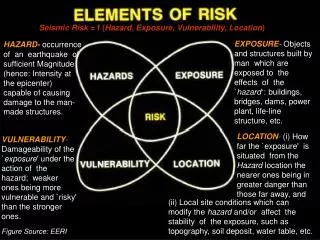
Seismic Vulnerability Risk Assessment for Essential Structures in Clark County Nevada
480 likes | 872 Vues
Seismic Vulnerability Risk Assessment for Essential Structures in Clark County Nevada Ronald L. Sack Tyson Day Arya Ebrahimpour Jared R. Keller Josh Baird Scope of the Project Part of a larger project entitled “ Earthquakes in Southern Nevada – Uncovering Hazards and Mitigating Risk.”

Seismic Vulnerability Risk Assessment for Essential Structures in Clark County Nevada
E N D
Presentation Transcript
Seismic Vulnerability Risk Assessment for Essential Structures in Clark County Nevada Ronald L. Sack Tyson Day Arya Ebrahimpour Jared R. Keller Josh Baird
Scope of the Project • Part of a larger project entitled “Earthquakes in Southern Nevada – Uncovering Hazards and Mitigating Risk.” • The objectives are to: • Perform risk assessment of the critical infrastructure in Clark County, Nevada(65 Fire Stations, 18 Police Stations, 3 Hospitals, 277 Schools); and • Develop a web- and GIS-based visualization product for general public, planners, and emergency response specialists.
Literature • Design provisions: • NEHRP Recommended Provisions, ASCE-7, UBC, and IBC (2000, 2003) • Evaluation tools: • ATC Reports, FEMA RVS Method, and HAZUS-MH Program (Levels 1, 2 & 3) • Technical articles • McCormack et al. (1997), Perry and O’Donnell (2001), Hwang, et al. (2000), etc.
Tools, Sources, & Communications • Evaluation tools selected: • FEMA-154 and HAZUS-MH (Level 2) • Sources of information • Building plans, web sites (longitudes and latitudes, addresses, etc.), CC Building Dept., CC School District, and UNLV faculty and students. • Communications • Web-based bulletin board • E-mail, telephone, mail, FAX, etc. • Project website: http://www.isu.edu/engineer/earthquake/
Remainder of the Presentation • Josh Baird: • Building Classifications • Example of Building Data Retrieval • Jared Keller: • Overview of FEMA 154 and HAZUS-MH • Example of Building Evaluation • Running HAZUS (after the presentation)
Building Classifications • Using FEMA 154 - Rapid Visual Screening of Buildings for Potential Seismic Hazards • Federal Emergency Management Agency • Data collection Forms • Building classifications • Explain Classifications • Example of a typical building
Description of Model Building Types W1: Wood Light Frame W2: Wood Frames Commercial and Industrial S1: Steel Moment Frames S2: Steel Braced Frames S3: Steel Light Frames S4: Steel Frames with Concrete Shear Walls S5: Steel Frame with Infill Masonry Shear Walls C1: Concrete Moment Frames C2: Concrete Shear Wall Buildings C3: Concrete Frame with Infill Masonry Shear Walls PC1: Precast/Tilt-up Concrete Shear Wall Buildings PC2: Precast Concrete Frames RM1: Reinforced Masonry Bearing Wall Buildings with Flexible Diaphragms RM2: Reinforced Masonry Bearing Wall Buildings with Stiff Diaphragms URM: Unreinforced Masonry Bearing Wall Buildings
W2: Wood Frames, Commercial and Industrial • Large apt. complexes, Commercial or Industrial structures • Usually 1-3 stories • 5,000 ft2 or more • Few interior walls (if any)
W2: Wood Frames, Commercial and Industrial • The floor and roof framing consists of wood or steel trusses, glulam or steel beams, and wood posts or steel columns. • Lateral forces are resisted by wood diaphragmsand exterior stud walls.
PC1: Precast/Tilt-up Concrete Shear Wall Buildings • One or more stories • Precast concrete perimeter wall panels cast on site and tilted into place • Steel plates provide connections (#7) • Lateral forces resisted by the precast concrete perimeter wall panels
PC1: Precast/Tilt-up Concrete Shear Wall Buildings • Wall panels may be solid, or have large window and door openings. • Foundations consist of concrete-spread footings or deep pile foundations.
RM1: Reinforced Masonry Bearing Wall Buildings with Flexible Diaphragms • Bearing walls that consist of reinforced brick or concrete block masonry (cmu) • Wood floor and roof framing consists of steel beams or open web joists, steel girders and steel columns (flexible) • Lateral forces resisted by the reinforced brick or concrete block masonry shear walls • Foundations consist of brick or concrete-spread footings.
Information Retrieval • Compiled List • Addresses • Plans (from website) • Year Built • No. of Stories • UBC Code used • Building Type • Total Floor Area (If not exact, estimated) • FEMA Data Form
Typical School • Hal Smith Elementary School • Find • Address • No. Stories • Year Built • Total Floor Area • Building Name
Information Retrieval • Address • From Compiled List • 5150 East Desert Inn Road, Las Vegas, NV, 89122 • No. Stories • From Wall Elevations • 15-20 feet / story • 1 story
Information Retrieval • Year Built • From Plans • 1999
Information Retrieval • Code Used • From Structural Drawings (usually) • 1994 UBC
Information Retrieval • Building Type
Information Retrieval • Building Type
Information Retrieval • Total Floor Area • From Plans
Information Retrieval • Total Floor Area • Total = 60,105 ft2
Hal Smith E.S. • Address • No. Stories • Year Built • Total Floor Area • Building Name • Falling Hazards • Building Type • Comments • Code Used
Analysis Overview • FEMA 154 • HAZUS-MH
FEMA-154 Overview • Rapid Visual Screening (RVS) of Buildings for Potential Seismic Hazards • Developed by the Applied Technology Council of Redwood City California under contract from the Federal Emergency Management Agency (FEMA) • Established a method for performing rapid on-site “sidewalk” surveys of existing buildings without requiring structural calculations • Using statistical analysis, a “structural score” for a building is developed; this score is then compared to a predetermined “cut-off score” • Buildings receiving a score lower than the “cut-off score” are determined as a potential seismic risk
FEMA-154 Uses • Ranking a community’s seismic rehabilitation needs • Design seismic mitigation programs • Develop inventories of buildings for use in regional earthquake damage and loss impact assessments • Planning post earthquake building safety evaluations • Developing building specific seismic vulnerability information
FEMA-154 Procedure Overview • Planning: • Selection of desired buildings to participate in the survey • Determination of “cut-off” score • The calculated final score is an estimate of the probability that the building will collapse; therefore a “cut-off” score is used to establish desirable seismic reliability • A score of 3 implies that there is a 1 in 1000 chance that the building will collapse • A score of 2 implies that there is a 1 in 100 chance that the building will collapse • A higher “cut-off” value implies greater desired safety but increased rehabilitation costs prior to an earthquake • A lower “cut-off” value equates to increased seismic risk with lower rehabilitation costs prior to an earthquake • A “cut-off” score of 2.0 is suggested based present seismic design criteria; therefore, for the purpose of this survey, a “cut-off” score of 2.0 will be used
FEMA-154 Procedure Overview • Planning: • Selection and Review of Data Collection Form • There are three predefined seismicity regions, namely High, Moderate, and Low) • Seismicity regions are defined based upon either the short or long period spectral acceleration response (SAR) for a given location • Low: Long Period (1.0 sec) SAR < 0.067g • Moderate: 0.067g < Long Period (1.0 sec) SAR < 0.200g • High: 0.200g < Long Period (1.0 sec) SAR • Seismicity regions can be determined by using NEHRP developed maps or the USGS web page • A seismicity region of “High” will be used for this study
FEMA-154 Procedure Overview • Completing the Data Collection Form: • Year built: • Used to determine if the building was built before or after significant changes to seismic design code were implemented • Total Floor Area: • Not directly used in calculating the structural score; however can be useful in determining rehabilitation/replacement costs • Building Sketches: • Used to determine if any vertical or plan irregularities exist • Can also aid in estimating total floor area
FEMA-154 Procedure Overview • Completing the Data Collection Form (Cont): • Soil Type: • The soil types are defined in accordance to NEHRP 1997 Provisions • Used to determine the modified structural score if applicable since buildings constructed on Hard Rock will behave differently than those constructed on Soft Soil • The basic structural scores presented in FEMA-154 were developed for an assumed Soil Type B (Rock) in accordance with the NEHRP 1997 Provisions • Building Type: • The building type is categorized into one of 15 classes based upon the structure’s primary lateral-load-resisting system
FEMA-154 Procedure Overview • Obtaining the “Structural Score” • The final “structural score” is determined by adding (or subtracting) the various score modifiers from the “Basic Structural Hazard Score” • Completing the Analysis • If the obtained final “structural score” is below the “cut-off” score the building will require additional evaluation with the aid of a qualified structural engineer • If the obtained final “structural score” is greater than the “cut-off” score the building should perform well in a seismic event
FEMA-154 Advantages/Disadvantages • Advantages: • Simplicity • Relatively low cost to gather the required field data • Provides effective estimates for determining future emergency planning or mitigation • Effective screening process for detailed evaluations • Disadvantages: • Generalized results for each building type • Pass/Fail results • Three pre-determined seismicity regions (lack of refinement) • Does not incorporate seismic event when determining the final “structural score” • Very conservative
HAZUS-MH Overview • Hazards, US—Multi-hazards • Developed by the Federal Emergency Management Agency (FEMA) by the National Institute of Building Sciences (NIBS) • Nationally applicable methodology for estimating potential earthquake losses on a regional basis. • Developed by a team of earthquake loss experts composed of earth scientists, engineers, architects, emergency planners, etc.
1.00 0.75 M Capacity Curve 0.50 Probability E PGA[C] C PGA[E] 0.25 PGA[M] PGA[S] SD[S] SD[E] SD[C] SD[M] Spectral Displacement (inches) Spectral Displacement (inches) S Probability HAZUS-MH Overview Demand-Capacity Curves Structural Fragility Curves Spectral Acceleration (g’s) Probability Distribution
HAZUS-MH Uses • Anticipating the possible nature and scope of emergency response needed to cope with an earthquake related disaster • Developing plans for recovery and reconstruction following a disaster • Mitigating the possible consequences of earthquakes • Generate an estimate of the consequence to a city, region, or location for a given earthquake with a specified magnitude and location
HAZUS-MH Overview • Planning: • Selection of buildings to analyze • Selection of scenario seismic event • Independent research • Provided historic seismic events • Select a location from a list of provided/known fault lines • Determine desired level of analysis/results • Structures • Lifelines • Economic/Social impact
HAZUS-MH Overview • Data Collection: • Same as FEMA-154 with a few changes • Year Built helps determine seismic design level (High, Moderate, or Low) • Floor Area is used to calculate expected building damage both physically as well as financially • Additionally: • Latitude and Longitude to adequately determine the ground response with respect to a given seismic event • Construction Quality: Inferior, Meets, or Superior to code • Estimated building cost • Occupancy load during different times of the day • Shelter capacity • Number of beds for hospitals or trucks for fire stations • Back-up power • Etc.
HAZUS-MH Advantages/Disadvantages • Advantages: • Flexibility • GIS platform • Provide estimates of the loss of functionality or percent damage for a given structure/facility • Provides effective estimates for determining future emergency planning or mitigation • Incorporates seismic event when determining probabilities • Disadvantages: • Complex data setup/collection (data manipulation) • Flexibility • Must perform a Level 2 analysis for competent results • Does not directly incorporate building characteristics such as soft stories or vertical/plan irregularities
Example • Hal Smith Elementary School • 5150 E. Desert Inn Rd Lat: 36.1295 Long: -115.0637 • Year Built: 1999 • Building Type: RM1 • Design Code: UBC 1994 • Area: 60,105 ft2 • Plan Irregularities: Yes • No. Stories: 1 • Vertical irregularities: No • Soil Type: D (assumed)
Example—FEMA Since FAILS Therefore it will require additional evaluation
Example—HAZUS-MH Hal Smith E.S.
Example—HAZUS-MH • Seismic Event: • Location of epicenter: (36.290, -115.160) • Fault name: Eglington • Magnitude: 6.30 • Depth: 12 km • Rupture Length: 12.94 km • Rupture Orientation: 0.00° • Attenuation Function: WUS Shallow Crustal Event-Extension * HAZUS Developed Long Period (1.0 sec) Contour Map
Probability Example—HAZUS-MH Estimated Structural Damage: Estimated Functionality
Example—Comparison • FEMA-154 • Ranks the building as a potential hazard • With a final score of 1.7 the probability of collapse is 2% • HAZUS-MH • Verifies that the high seismicity FEMA region is appropriate • Demonstrates that significant damage is possible
Project Update • Building Analysis • 20 of 65 Fire Stations • 3 of 18 Police Stations • 3 of 3 Hospitals • 73 of 187 Elementary Schools • 0 of 51 Middle Schools • 14 of 39 High Schools
Issues • Seismic Event • What is an appropriate event? • What is a likely event? • Magnitude • Epicenter • Depth • etc. • Data Entry • Database manipulation • Software compatibility • Manual entry
Proposed Project Uses • FEMA-154 Results: • Develop a list of potentially hazardous buildings • HAZUS-MH Results: • Estimate regions that are more susceptible to seismic events • Estimate loss of functionality for specific buildings • Overall • Develop a mitigation plan for seismic rehabilitations • Develop a list of buildings that may be used as shelters • Develop a better understanding of building behavior for a given building type (RM1, PC1, etc) • Develop a contingency plans for emergency response