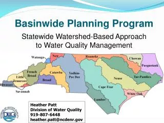
Basinwide Planning Program
Basinwide Planning Program. Statewide Watershed-Based Approach to Water Quality Management. Heather Patt Division of Water Quality 919-807-6448 heather.patt @ncdenr.gov. Water Quality in the Kerr-Tar COG Region. Map shows Impairments in Red. 1) How does DWQ make WQ assessments

Basinwide Planning Program
E N D
Presentation Transcript
Basinwide Planning Program Statewide Watershed-Based Approach to Water Quality Management Heather Patt Division of Water Quality 919-807-6448 heather.patt@ncdenr.gov
Water Quality in the Kerr-Tar COG Region Map shows Impairments in Red 1) How does DWQ make WQ assessments 2) What can be done at the local level
Stream Classification System • Defines a stream’s best use(s) • Defined in both narrative & numeric Standards • Basis for policies http://portal.ncdenr.org/web/wq/ps/csu
DWQWater Quality Assessment • Every two years – determine how well our water bodies supports their designated uses. • Designated uses are bases on stream classifications • Class C – Protection and propagation of aquatic life; Fish consumption; Secondary Recreation • Class B – Recreation (Swimming) • Class WS – Water Supply • Supplemental (NSW, ORW, HQW, TR, SA)
Water Supply (I,II,III,IV & V) • WS-Iprovides the highest level of protection • WS-Vprovides for lower protection
Supplemental Classifications • NSW - Nutrient Sensitive Waters • HQW - High Quality Waters/ WSW • ORW - Outstanding Resource Waters
Determining how well a water supports its designated uses (based on classification) is a means of interpreting data and assessing water quality. These assessments result inUse Support Ratings.
Data Collection and Information Used • Biological (fish & macroinvertebrates) • Chemical/Physical (ambient monitoring) • Lakes • Fish Consumption • Swimming Advisories • NPDES Discharge Performance Data • Land Use and Cover • Other Monitoring Data
Aquatic Macroinvertebrates • Number of Insects • Diversity of Species • Abundance of Species • Pollution Tolerance
Fish Community Assessments • Numbers of Species • Diversity of Species • Abundance of Species
Aquatic Life • Ambient Monitoring Criteria based on Numerical Standards • Parameters Assessed: • Dissolved Oxygen • pH • Chlorophyll a • Turbidity Waters that exceed standard in greater than 10% of samples areImpaired.
Ambient Data is quantified in 5 year intervals • Latest data is available from EPA’s STORET website http://www.epa.gov/storet/
Recreation • Assessed for all Monitored Waters • C, SC, B, SB, SA, WSI-WSV • Parameter Assessed: Fecal Coliform Bacteria • Data Sources: • Ambient Monitoring Stations • DWQ Special Studies • DEH Recreational Monitoring Advisories (RECMON)
Water Supply Assessed for All WS Waters • Criteria based on the ability of water treatment plants to deliver potable water; not on standards for raw water. • Regional water treatment consultants provide water quality related intake closure information. • All WS waters areSupportingon an Evaluated basis.
DWQ Water Quality Assessment • Use Support Ratings • Supporting – No criteria exceeded • Impaired – Criteria exceeded • Not Rated – Inconclusive information/data • No Data – No assessment made
Use Support Ratings are used… • To compile the 303(d) List of Impaired Waters for EPA. • To develop management strategies or highlight problems within basinwide plans. • Impact Permitted Activities • By interest groups to develop grants and projects.
Management Strategies & TMDLs • Required for waters on the state’s 303(d) List of impaired waters • A TMDL must be developed for each problem parameter on the list • Each TMDL must take into account all potential sources of pollution • TMDL = Total Maximum Daily Load
Tools & Strategies DWQ Utilizes to Restore Streams • Work with stakeholders/watershed groups to develop watershed restoration plans • Encourage local ordinance adoption of stronger stormwater regulations (USMP) • Development of specific management strategies and rules (NSW, Jordan Lake, Falls Lake, Randleman Lake) • Development of TMDL for a specific stream reach and pollutant of interest or implementation of a restoration plan targeting the specific pollutant
General River Basin Information • Total Area 6,148 mi2 • Freshwater Stream Miles 2,521 miles • Freshwater Lakes/Reservoirs 3,977 acres • Saltwater/Estuarine Acres 663,504 acres
NSW Needs • Recommendations for additional research • Groundwater • Atmospheric deposition • Tile drains • BMP efficiencies • Ag nutrient accounting • Existing development nutrient loads • Estuary nutrient recycling
What Can You Do To Reduce Stormwater Pollution? • Divert roof drains to vegetated areas • Use rain barrels/cisterns • Convert lawns to natural area • Vegetate bare areas • Use environmentally friendly lawn care • Keep storm drains clean • Inspect/maintain septic systems • Pick-up pet waste • Restore stream buffers • Support land use & stormwater planning • Minimize paved areas or use pervious pavement materials • Prevent vehicle leaks • Wash vehicle on grassy areas
Local Planning Considerations • Avoid Areas Near Sensitive Waters • Maintain Buffer Areas Around Streams • Consider Land Constraints - slope/soil • Maintain Areas of Open Space • Minimize Impervious Cover • Protect Floodplains
What can local governments do to reduce stormwater pollution? • Limit impervious (hard) surfaces by concentrating development in high density clusters. • Establish & review zoning standards for development to reduce runoff and protect stream corridors. • Preserve floodplain functions. • Protect farmland and open spaces.
ENVIRONMENTAL QUALITY ECOMONIC GROWTH QUALITY OF LIFE
Contact Info Heather Patt- Basin Planner 919-807-6448 heather.patt@ncdenr.gov
Water Quality Impacts of Urbanization Increased • Stream bank erosion • Sedimentation\Turbidity • Water temperatures • Conductivity • Pollutant Concentrations (nutrients, pesticides, oils, metals) • Bacterial loading (animal and human waste) • Algal/Periphytic growth • Water supply treatment cost Decreased • Aquatic habitat • Aquatic biodiversity • Aquatic health & reproduction • Dissolved Oxygen • pH