Developing GIS at Furman University: Innovations in Research and Education
This outline discusses the development and integration of Geographic Information Systems (GIS) at Furman University from its inception in the 1990s through collaborative research initiatives involving economics and environmental sciences. It highlights key milestones, including software acquisition, the establishment of dedicated labs, and the launching of innovative courses in GIS and remote sensing. Key projects, such as the River Basins Research Initiative, explore the intersection of water quality, environmental economics, and smart growth in urban planning, underscoring the importance of GIS in academic research and student learning.

Developing GIS at Furman University: Innovations in Research and Education
E N D
Presentation Transcript
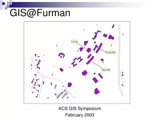
GIS@Furman ACS GIS Symposium February 2003
Outline • GIS on Furman’s Campus • Software/hardware acquisition • Faculty-Student collaborative research • Teaching
GIS Comes to Furman • Before 1994 • History Professor authors own software tools for spatial analysis of historical events. • 1994 • Economics faculty receive grant to install new computer lab to support “engaged” learning activities in economics. • As an experiment, five copies of MapInfo are purchased out of grant money in 1995-96.
GIS Comes to Furman • 1996-2001 • Learning GIS software (self-taught). • Explored applications to economics research and teaching. • Thematic mapping in lectures and limited use by students in classes. • Economics lab converts to Arcview due to widespread use by local planning agencies and aggressive academic pricing by ESRI. Expanded to 21 workstations. • River Basins Research Initiative begins. • 2002 • Hire Suresh to teach GIS and Remote Sensing courses...housed in Earth and Environmental Science. • 2003-2004 • First GIS course offered on Furman campus. • One advanced user, one intermediate user, several beginners.
River Basins Research Initiative • River Basins Research Initiative, begun in 1996 by science departments, focused on water chemistry and biological diversity in the Enoree and Saluda River basins in “Upstate” South Carolina. • Social science students and faculty joined the project during summers 2000 and 2001. Participation by 36 Furman students and 24 non-Furman students for ten weeks during each of two summers. • Economists focused on valuation of rivers and streams, “cleanliness” of rivers and streams, and “smart growth” neighborhood design characteristics.
Do House Prices Rise with Proximity to Rivers and Streams? • Database of 10,000 house sales geocoded.Combined with “Reach 3” river and stream data to compute distances from houses to rivers. • House prices correlated with house characteristics, neighborhood characteristics, and proximity to rivers and streams. • Also incorporated cleanliness indicators produced by science teams. • House prices weakly correlated with proximity to river...but not a robust finding.
Willingness to Pay for Cleaner Rivers and Streams • Survey elicited willingness to pay for cleaner rivers and streams. • Survey respondents’ addresses were geocoded, and distances to streams were calculated. • Willingness to pay for cleaner streams rose with income, fell with the cost of cleanup, and fell with proximity to streams.
Do House Prices Reflect Parents’ Valuation of School “Quality”? • GIS used to attach schools to houses from house sale database. Average standardized test scores then “attached” to each house in database. • House sale price correlated with house characteristics, neighborhood characteristics, and school test scores. • Result: People are willing to pay more for houses with higher elementary school test scores. Less clear for middle and high schools.
Valuing “Smart Growth” Neighborhood Design Characteristics • Smart growth advocates mixed-use zoning to reduce distances between homes, schools, work, and commercial areas. • Streets in a grid pattern to facilitate flow of traffic (as opposed to cul de sacs). • Pedestrian-friendly areas. • Green spaces.
Valuing “Smart Growth” Neighborhood Design Characteristics • Schools, grocery stores, drug stores, parks and child care centers are geocoded. • Presence/absence of protected pedestrian areas is “attached” to each house. • Number of streets terminating within a fixed radius of a house is recorded. • Distances from houses to schools, grocery stores, etc. are calculated and correlated with house prices, holding constant house and other neighborhood characteristics. • House prices are correlated with proximity to commercial and noncommercial enterprises, green spaces, presence of protected sidewalks, and “gridded” streets.
Lessons Learned • Data management is a challenge. • Get to know your local county or city GIS experts...their data are invaluable and their expertise can be helpful. • We tended to re-create data layers across disciplines. Creating a clearinghouse of shapefiles (with descriptions of the data) would have been useful. Perhaps library can assist in future. • GIS expertise quickly becomes a constraint. • How to compute distances from houses to nearest grocery store via road rather than linearly (“as the crow flies”) for each of 10,000 houses in database? • How to count the number of roads terminating (e.g., cul de sacs) within a half-mile radius of a house? • How to create commercial density statistics for each of 10,000 geocoded houses in database? • Memory and hard disk space quickly become a constraint when working with larger GIS files or many layers.
Classroom Use of GIS • Population, Economy, and Society • Urban Economics • Economics of the Environment • Gallery follows...
Definitions of Urban Areas Density and economic activity define “urbanness” to the urban economist. Density is population per unit of land area Population/(square miles of geo. unit)
Walmart Walmart Grocery Store Applying Market Area Analysis to Greenville
Mill Village LayoutEconomics of Agglomeration:Why Do Cities Exist?
Lessons Learned • Get to know your local county or city GIS experts...their data are useful! • It is easy to teach students how to create thematic maps using shapefiles that are already prepared for them. I should do more of it than I currently do... • It is costly to teach students how to prepare data files to join with existing data or to do complex queries and joins. The summer research experience provides an excellent opportunity to do this in a less frantic manner. • An efficient mechanism for sharing spatial data across disciplines and institutions would be very useful. Startup costs for accessing Census data, for example, are pretty steep. The library might act as data clearinghouse.