
Scriba's Creek Channel Alignment History
Explore historical maps and modern field conditions to accurately position the present stream alignment on a 200-year-old map of Rotterdam (Constantia). Follow the evolution of Scriba's Creek, including the meandering pattern, mills, and road transformations over time.
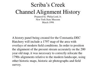

Scriba's Creek Channel Alignment History
E N D
Presentation Transcript
Scriba’s Creek Channel Alignment HistoryPrepared by: Philip Lord, Jr.New York State MuseumMarch 1998 A history panel being created for the Constantia DEC Hatchery will include a 1797 map of the area with overlays of modern field conditions. In order to position the alignment of the present stream accurately on the 200 year old map, it was necessary to correctly relocate the 1790s alignments relative to the modern landscape, using other historic maps, historic air photographs and field survey.
Map of Rotterdam (now Constantia) in Scriba Papers, c.1797: This is the map to be used on the history panel. Although some of the street plan is projected as it might one day look, the stream alignment, mills, houses and main road [George Street, now Rte. 49] are accurately drawn. The reversed “S” meandering in the stream no longer exists.
This sketch map from the Scriba Papers [New York State Library] dates to around 1794 and is labeled “Survey of 3 Lotts on the East Side of Scribas Creek at Rotterdam Oneida Lake”. It shows in more detail the reverse “S” meander pattern, as well as the location of two mills and associated mill races. Note the position of the road, which is now on the alignment of Rte. 49 east of the creek.
The first step was to try and match the more detailed Scriba sketch map of the meanders (redrawn as an overlay, above) to the 1797 map of Rotterdam. Both documents had north arrows and both revealed the same reverse “S” meander pattern in the creek. But it was not possible to match them entirely. The mills shown on the sketch map are located close to the ones indicated on the 1797 map.
Finding the True Scale: Fortunately the 1797 map was drawn to scale. The given scale is five chains to an inch. A chain is 66 feet long, so on this map, one inch equals 330 feet. The c.1794 sketch map of the meanders of Scriba Creek did not have a scale. However, we can match this drawing to the 1797 map (see previous page) and thus can develop a scale for the 1794 sketch. By superimposing a scale of feet (rather than chains) on the 1794 and 1797 maps, we can begin to relate historic stream features to the modern landscape. To accomplish this, we needed an image of the modern landscape, in this case an aerial photograph, and we needed to apply a scale to it. Because the features shown on the 18th century maps no longer show up clearly on the aerial photographs, another method of matching scale was devised. 2,310 1,980 1,650 1,320 990 660 330 0
Kibbie Lake Road 1,500’ Rte. 49 Scale for the aerial photographs was determined by taking the distance along Rte. 49 between the bridge over Scriba Creek and the intersection of Kibbie Lake Road, which was approximately 1,500 feet as indicated on USGS topographic maps of the area. This then allowed us to matching the historic maps with the air photos.
1500 ft A B Overlay onto 1938 aerial photograph: We know from the scale on the 1797 map that 1,500 north from the 18th century mouth of Scriba Creek brings you to the very top of the reverse “S” meander, about even with “Second Street” (see 1797 map). So we can take the overlay we drew from the c.1794 sketch map of those meanders and lay it onto the 1938 air photo, matching the mouth of the creek to what would have been the mouth 200 years ago and matching the roadway to Rte. 49. Interestingly, that puts the top of the meanders [A] right on top of an old meander scar just south of the RR and wraps the westerly loop of the meanders [B] around a plot of lowland of the same shape west of the present creek.
The Blow-out: In a classic stream evolution pattern, Scriba’s Creek appears to have burst through the 18th century double curved meander pattern with a straight-line flood that cross-cut both loops of the previous meander. This blow-out was completed in 1906,according to local records, but part of the transition may have already occurred earlier. It appears that the mill races, which cut across the loops of the meander to provide power to the two mills, provided the channels for the course of the blow-out, which seeks the path of least resistance. Look at the 1794 [next slide] sketch to see how these mill races may have facilitated this blow-out and cut-off that produced the modern alignment.
Path of Least Resistance: The 1794 sketch map of Scriba’s Creek shows the reverse “S” meanders and two mills, each located at the downstream side of the neck of a meander. This is a classic water power set-up, for the power transmitted to the mill’s water wheel depended on the drop or “fall” in the waterway. By cutting the headrace across a meander neck, the millwright created the maximum fall with the shortest race. In normal operation, the old channel of the stream served as an overflow or “waste” when the race was shut, or when excess water came down the system. However, in flood stage, these raceways provided a “weak” point in the system, and offered the powerful freshet a low point to run into, thus cutting a new channel that by-passed the original meandering of the natural stream. Illustration at left taken from: Lord, Philip L. Jr. Mills on the Tsatsawassa: Documenting Early Water-Powered Industry in Rural New York. NY State Museum, 1983.
A B C D Meanders and Chute Cut-offs Any stream develops slight meandering over time [A], and soon these meanders start cutting toward their points [B]. Eventually the meanders become extreme [C]. This is the stage of stream evolution shown on the 1797 map of Rotterdam. At this point there is danger during flood stage of the stream bursting through and creating a short-cut route, called a “chute” or “cut-off” [D]. This happens naturally in many cases. However, in Scriba’s Creek a weakness in the channel was created by the digging of two mill races to bring water to two millwheels [E]. In essence, these races anticipated the chutes which the stream probably would have developed on its own during the coming years, as deforestation of the uplands produced larger and more destructive spring floods. As a result, the stream developed its present alignment [F]. E F
A B C D E F G 1967 1938 Comparison of these two views, taken about thirty years apart, shows the changes evident in the landscape. A large pond has been created [A] by damming and a number of fish ponds are evident [B]. Although the main channel [C] has remaining constant, the old meander scar at the north end of what was in 1797 the reverse “S” meander [D] is less evident, the lower leg of that meander [E] is shown holding water, and the area of the lower meander [F] appears filled and built upon. The delta at the mouth of the creek [G] continues to be expanded.
Results of Field Survey: Field inspection revealed the extent of the elevated plateau areas surrounding the stream: Based on this topography, which included a small area of elevated land within the supposed 1797 meander of the stream - the position of the 18th century meander pattern could be estimated -
Map of Rotterdam (now Constantia) in Scriba Papers, c.1797 with modern features indicated, including the present stream alignments, the streets in the vicinity, and the hatchery building’s approximate location.
1500 ft A B Composite overlay on 1967 air photo of of 1794 stream alignment and modern stream, road and hatchery locations.