Chapter 10: data telemetry
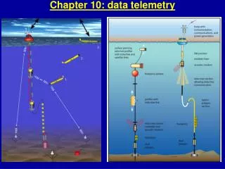
Chapter 10: data telemetry. A: data telemetry to shore. Low Earth Orbit Satellites: Argos Iridium Orbcomm Global Star FleetBroadBand and C-band Cellular and freewave modems Need to compare: Coverage Cost of service/equipment Data rate Power requirements. Satellite data path.

Chapter 10: data telemetry
E N D
Presentation Transcript
A: data telemetry to shore • Low Earth Orbit Satellites: • Argos • Iridium • Orbcomm • Global Star • FleetBroadBand and C-band • Cellular and freewave modems Need to compare: • Coverage • Cost of service/equipment • Data rate • Power requirements
Satellite data path • Transmitters send data to satellites • Satellites collect the data, store it and relay it in real-time back to earth • Ground antennas relay data from satellites to processing centers • Processing centers collect the incoming data, process it and distribute as necessary • Users get the data
Argos - satellites • Global coverage • Polar orbiting environmentalsatellites (at least 2 at all times; can get extra service which gives more satellites at one time) • 850 km above earth with a 5000 km footprint • Duration of satellite pass is 10 minutes on average • ~ 100 minute orbit • Depending on latitude 20-50 passes per day • 40 ground receiving stations
Argos platforms (transmitters) • Transmit frequency of 401.650 MHz ± 30 kHz • Repetition rate depends on application, but every 45-90 seconds is common for oceanography instruments at the surface • Usually one 32byte message every 45-90 sectotal is less than 10kb per day • Have to transmit for hours since time of satellite pass unknown (high power consumption) • Message includes: • Statement of message length • Transmitter ID number • Sensor data from 32 to 256 bits • Used by Argo, DBCP (drifting buoys), SOOP, moorings, ice buoys
Argos extra/added-value services • Processing centers process data, offer many dissemination routes (web, email, fax, telnet, etc), and archive data for up to 6 months • Gives a position for platform based on measured Doppler shift; accuracy ranges from better than 150 m to more than 1000 m • Can put data onto the Global Telecommunication System (GTS) & make it publicly available • Will soon be (may have already started) offering Argos 3 with the following upgrades: • Two-way communication • Faster data rate – 4.8 Kbytes/second • Greater data volume transmission (up to 10x current capacity) • Confirmation when message has been received error-free • Calculate time and date of satellite pass (can surface at that time)
Argos costs • Basic Service • Buoys $5.60 per PTT-day unit • Floats $8.40 per PTT-day unit • A day unit is ¼ of a day or a 6 hour period • Additional fees • Monthly active PTT fee $13.90 per PTT/month • Unused ID numbers $4.50 per PTT/month • Email or file transfer $0.12 per kilobyte • Example calculation • PTT cost/month = A + [B * # of PTT-day units] • A is monthly active PTT fee; B is PTT-day rate depending on PTT Bird carrying a PTT designed to transmit every day in a month, but only 8 hours a day. Usually heard from in 2 daily time slots (sometimes 3). • PTT cost/month = $13.90 + [$8.40 x .5(30 PTT day units)] = $139.90 • Discounts for large programs on B coefficient Cost is independent of data volume, only depends on number of active days
Iridium • Commerical global satellite voice and data system • 66 low-earth orbiting satellites (plus 6 in-orbit backups) • Cross-linked to 4 other satellites • 100 minute orbit • 780 km above Earth • 40 ground stations • 2 way communication
Iridium • Short Burst Data (SBD) – email messages allows short data transactions at about 2 Kbits/second • Dial-up Data – works like a modem with a 2.4 Kbits/second rate,in practice 1600bits/sec • new RUDICS service, TCP/IP like internet connection, nominally 4800baud, in reality 2500-3000baud or 250by/second • Used by some Argo floats, all gliders, some moorings • Possible decreased battery usage as compared to Argos where instrument must transmit for longer time periods • Decreased surface time = reduced risk of damage done to instrument at surface
Iridium cost • Iridium charges by the byte & a small monthly charge of ~ $15 • Can buy from value added reseller (VAR) or a provider • VAR sends data by email or you set up a dedicated server for a direct IP connection • Provider links to Iridium for you and emails the data (optionally archives the data and creates a website for you to access the data) • SBD charge: $1.50/kbyte, provider with archiving ~ $3.00/kbyte • Dial-up at 1600bit/sec and $0.80/minute (iridium to iridium) to $1.50/minute (lridium to landline) means $0.07-$0.15/kbytei.e. 10-20 times cheaper than SBD/email service • RUDICS service: 3000bit/sec (=250by/second) at $0.67/min, i.e. $50/MB. But high start-up charge of $750 for first SIM card, and $40/month
Iridium Flares: http://www.heavens-above.com SIO pier has 32.8662 N 117.2541W
Orbcomm • Commercial global satellite system for machine to machine (M2M) communications • 30 low earth orbit satellites • ~ 100 minute orbit • 757 km above Earth • 13 ground stations • 2 way communication
Orbcomm data rates & cost • Data uplink rate: 2.4 Kbytes/second • Data downlink rate: 4.8 Kbytes/second • Services sold through VAR • Byte charge: $5/1000 bytes • Basic modem: $275 • Antenna with GPS: $100
Globalstar • 40 low earth orbit satellites • 1500 km above Earth • Not global, but covers coastal regions & North Atlantic fairly well • Several satellites pick up one call and simultaneously transmit data to back to ground • Can send data at 9.6 Kbytes/second for uncompressed data and up to 38.6 Kbytes/second for express data service
Globalstar cost • Similar to Iridium – sold through VAR or a provider for roughly the same price per Kbyte & monthly service fee • Equipment needed is less expensive than Iridium • Used in coastal lagrangian drifters
LEO Satellite system comparisons • Argos: • Created for scientists, reliable • Gives a position without GPS • Extras are helpful – archiving, GTS, etc • Slow data rate • Current system doesn’t offer 2-way communication, but Argos 3 should (very soon) • Floats must be at the surface for a longer period of time to ensure complete message transfer • Iridium & Orbcomm: • 2-way communication • Faster and service can be cheaper than Argos • Floats/gliders need be at surface for minutes instead of hours to send data • Confirmation that message was received • Globalstar: • Much cheaper and faster than other systems • Only in coastal areas for the most part • One or two way communication All systems need several watts (1-3W Argos, 5W others) so energy need depends on length of transmission/data rates
C-band, Ku-Band, Ka-Band • Refers to the microwave range of frequencies from 4 to 8 GHz • Used with geostationary satellites • Require big directional antennas (0.6-2.4 m), i.e. need to track satellite on moving platforms !!! • Super high data rate – up to 2 Mbytes/second • Used on ships or large buoys • Needs kilowatt power
FleetBroadBand(new INMARSAT internet service) 1.5-1.6 GHZ
Cellular Modem • Uses the cellular phone network to transmit and receive data, with enhanced data modes (GPRS, EDGE, 3-G) • Fast data rate – minimum 9.6 Kbit/second up to 56kbaud • Provides direct internet connection, and thus 2-way communication • Good for coastal applications • Need to be where cellular networks are located • Pricing may be reasonable depending on the plan offered. Often just a flat rate like $40-70/month, so good if sending lots of data frequently. • Uses approx. 4W power while transmitting, less than 1W when idle, so may want to power down when not in use (but then not reachable).
Freewave Modem • Uses spread spectrum radio signals in the 900 MHz range • Spread spectrum radio – uses wide band, noise-like signals. Very secure, less prone to jamming and interference. • Transmits well though glass, wood, plaster • Range of 15 km with 7.5 cm antenna • Speed ranges from 1.2 to 115 Kbytes/second • Need to set up own/dedicated receiving station for each unit • Good for coastal applications • 10W power typically
B: Underwater telemetry • Acoustic links • Inductive links
Acoustic modem here (Teledyne) Benthos Cost: $9000 ($5000 OEM version)
Baud rate: Available are 140,300,600,800,1066,1200 bit/sec Power consumption: 7.5/B amp-seconds/byte where B is the measured baud rate. The battery supply is a nominal 21 volts. The full alkaline battery pack is 28 Amp-hour. The number of bytes you can send depends upon how long the modem is sitting idle waiting for the other end to ask for data. The full memory of the modem is 700 Kbytes. The modem uses 9.6 mWatt when in the low power state. Approximately one could have a modem idle for a year and still send 700Kbytes at 140 baud. We now have lithium batteries installed, and with the current glider-mooring success rate (over up to 7km range), we expect to have 2-year life and telemeter approx. 2MB
Inductive modem (here Seabird):cost: $500 (SIM) Speed 9600baud 30mA @ 12-25V 1 hour transmission needs 30mAh and gives 4Mby data. So with battery pack similar to Benthos modem could transfer 3-4Gbytes !
C: Surface and subsurface (emergency) beacons • Surface beacons validate position and maybe functioning of system (mainly moorings). They transmit regularly on a fixed schedule. • They may also act a recovery aid. • Subsurface beacons are used for emergency locator transmitters.They • alert owner in case of unforeseen surfacing • allow tracking of surfaced/drifting components until rescue • allows location of equipment after regular release (may need direction finders) • triggered by pressure, or conductivity switch, or light (careful near surface, may need red filters etc)
XEOS Sable XEOS Melo Iridium beacons: have GPS position (better accuracy) and 2-way communication (saves power)