Download
1 / 3
30 likes | 149 Vues
EPA Geospatial Data Access Project RCRA LQG Information Combined with DWMAv3 SPAs. http://www.epa.gov/enviro/geo_data.html Last updated on Tuesday, April 27, 2010

E N D
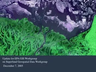
EPA Geospatial Data Access Project RCRA LQG Information Combined with DWMAv3 SPAs http://www.epa.gov/enviro/geo_data.html Last updated on Tuesday, April 27, 2010 To improve public health and the environment, the EPA collects information about facilities or sites subject to environmental regulation. The EPA Geospatial Data Access Project provides a downloadable files of these facilities or sites in the following formats; extensible markup language (XML) file, keyhole markup language (KML) file, ESRI Shapefile and ESRI Feature Class. Within the file is key facility information, along with associated environmental interests for use in mapping and reporting applications. RCRA_LQG shapefile was selected based on points where the contents of RCRA1_INT through RCRA6_INT contained the string "LQC." This involves 22,435 facility points. The geospatial metadata file for the complete multi-program shapefile "GEODATA_SHAPE_APR_2010" is included. Using DWMAv3 SPAs (for GW wells, inland SW SPAs, and coastal SW SPAs), geospatial tables were created showing, for each LQG site non-sensitive information on the SDWIS IDs for SPAs containing an LQG point. In many instances, a single LQG point can fall into more than a single drinking water SPA. From the total of 22,435 LQG points, 11,817 LQG’s were within SPAs. LQGs with Groundwater SPAS: 188 [example table - SPAGW.dbf] LQGs with Inland Surface Water SPAs: 4854 facility points [example table - SPAINL.dbf] LQGs with Coastal surface Water SPAs: 168 facility points [example table - SPACST.dbf] SPAs available for the CONUS, AK, HI and PR [Note: SPAs available for the CONUS, AK, HI & PR; no SPAs available for the U.S. Virgin Islands at this time]
RTI web service concept paperand examples of service output tables Chris Clark (OEI), Exchange Network Tools and Shared Services, Environmental Information Symposium 2010, “Enabling Environmental Protection through Transparency and Open Government,” May 10-13, 2010, Philadelphia, PA. http://www.epa.gov/oei/symposium/2010/clark.pdf
RCRA LQGs with DWMAv3 SPAs RCRA LQG facility points within SPAs Example of RCRA LQC “Input” & Drinking Water SPA Proximity Indicator “Output”