Download
1 / 13
130 likes | 228 Vues
Study the Butler Model on maps to analyze resort development stages, grid references, and physical/human factors influencing tourism destinations. Includes map evidence, directions, and historical analysis. Half-term homework included.

E N D
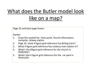
What does the Butler model look like on a map? Page 35 and back page Green: Starter: Draw the symbol for: View point, Tourist information, campsite, railway station Page 35- what 4 figure grid reference has Birling Carrs? What 4 figure grid reference has Lesbury train station in? What’s the 6figure grid reference for the church in Shilbottle? What’s the 6 figure grid reference for the car park in Alnmouth.
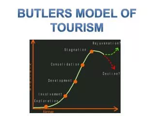
What evidence would you expect to see on a map of resort development? • Exploration? • Involvement? • Development? • Consolidation? • Stagnation? • Decline? • Rejuvenation?
Physical factors for the tourist resort • Why would people go on holiday here? • What are their 6figure grid references?
Human factors for the tourist resort • Why would people go on holiday here? • What are their 6figure grid references?
What is the evidence on this map of resort development? • What are their 6 figure grid references? • What different stages would you put these facilities/functions at?
General map questions • What direction is the River Coquet flowing in? • What do you think might happen at 233,045? • (Thinking back to settlement unit) Why do you think Warkworth has been built in this location? • Describe Warkworth’s site and situation. • What are the main directions that the roads go in? Why do you think they are designed like this? • Compare the land use of 26 04 and 19 14. Why do you think they are so different?
Half term homework • Practice 4 and 6 figure grid references online • Describe the pattern shown in the graph below. • Explain reasons for the growth in tourism. Use data in your answer. • For 2 places (Ibiza or KohSamuior Machu Pichu AND Malham or Bibury or Kendal) create a detailed flow diagram explaining the effects of tourism. Think positive and negative. Economic, Social and Environmental. You will have to do some research of your own to get facts to support your points.
Half term homework • Practice 4 and 6 figure grid references online • Describe the pattern shown in the graph below. • Explain reasons for the growth in tourism. Use data in your answer. • For 2 places (Ibiza or KohSamuior Machu Pichu AND Malham or Bibury or Kendal) create a detailed flow diagram explaining the effects of tourism. Think positive and negative. Economic, Social and Environmental. You will have to do some research of your own to get facts to support your points.