Advancing RFI Mitigation: Adaptive Algorithms for AMSR-E SST Retrievals
This presentation discusses the development of adaptive algorithms aimed at improving the retrievals of Sea Surface Temperature (SST) from AMSR-E data, particularly in the presence of Radio Frequency Interference (RFI). Emphasizing the transition from RFI 1.0 to RFI 2.0, it highlights the challenges posed by surface-based and geostationary satellite RFI, showcasing results from seven months of data analysis. The findings aid in better identifying and filtering RFI to enhance the accuracy of ocean measurements and inform future remote sensing methodologies.

Advancing RFI Mitigation: Adaptive Algorithms for AMSR-E SST Retrievals
E N D
Presentation Transcript
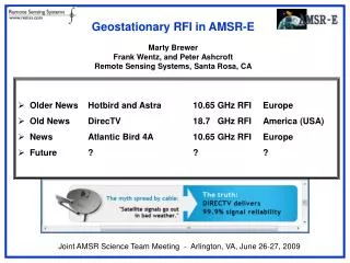
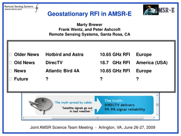
AMSR-E RFIUpdate - Towards RFI 2.0 - Adaptive Algorithms 1.0 Marty Brewer and Kyle Hilburn Frank, Carl, Chelle, et. al. Remote Sensing Systems AMSR Science Team Meeting Portland, Oregon, 2012.Sep.11-12
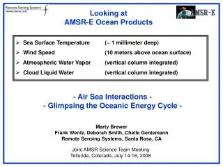
RFI • Surface Based (~7GHz) • Ascension Island, Hawaii, Netherlands, etc. • GeoStationarySatellites (11GHz, 18GHz) • “Space Based” • “Ocean Reflected”
RFI • RFI 1.0 • We know where it’s coming from. • We can filter it. • RFI 2.0 • We don’t really know where it’s coming from. • We can retrieve around it.
Fishing for Geostationary RFI • Data used: AMSR-E, March-September 2011 (7 months) • RFI is very much a moving target • Calculated the longitude and latitude where the reflection of the boresight vector from the surface crosses geostationary altitude (35,786 km) • For this analysis: • histograms of geostationary crossing longitude at 0.1 deg resolution • maps of fraction of observations affected by RFI • RFI defined as: SST or Wind diff > threshold • 4 different thresholds (1, 3, 6, and 9 K or m/s) • Required geostationary latitude to be within +/- 5 deg of equator • Removed: land, ice, rain, sun glitter; used both asc/dsc passes
SST LO-VL > 1 K (Weak RFI) Smooth Seas (wind speeds < 7 m/s) Glassy Seas (wind speeds < 3 m/s)
SST LO-VL > 3 K (Medium RFI) Smooth Seas (wind speeds < 7 m/s) Glassy Seas (wind speeds < 3 m/s)
SST LO-VL > 6 K (Strong RFI) Smooth Seas (wind speeds < 7 m/s) Glassy Seas (wind speeds < 3 m/s)
SST LO-VL > 9 K (V.Strong RFI) Smooth Seas (wind speeds < 7 m/s) Glassy Seas (wind speeds < 3 m/s)
Wind MD-LO > 1 m/s(Weak RFI) Smooth Seas (wind speeds < 7 m/s) Glassy Seas (wind speeds < 3 m/s)
Wind MD-LO > 3 m/s(Medium RFI) Smooth Seas (wind speeds < 7 m/s) Glassy Seas (wind speeds < 3 m/s)
Wind MD-LO > 6 m/s(Strong RFI) Smooth Seas (wind speeds < 7 m/s) Glassy Seas (wind speeds < 3 m/s)
Wind MD-LO > 9 m/s(V.Strong RFI) Smooth Seas (wind speeds < 7 m/s) Glassy Seas (wind speeds < 3 m/s)
Geostationary Fishing Results • The analysis finds good agreement between geostationary longitude histogram peaks and the longitudes of: • HotBird (13.0°) • Astra (19.2°) • Astra (28.2°) • EutelsatW2A (10.0°) • Presence of land can give peaks off the nominal longitudes • AtlanticBird4 (352.8°) peak is 5-10° west of nominal longitude • For 18.7 GHz RFI: DirectTV peaks are about 10° west and east of the nominal longitudes (257.2° and 260.8°)
Geostationary Fishing 2.0 • Assume GeoStatSats are equatiorial • Look at latitudes as well as longitudes • Geostationary Altitude Sky Maps
SST LO-VL > 1 K (Weak RFI) Smooth Seas (wind speeds < 7 m/s)
SST LO-VL > 1 K (Weak RFI) Glassy Seas (wind speeds < 3 m/s)
SST LO-VL > 6 K (Strong RFI) Smooth Seas (wind speeds < 7 m/s)
SST LO-VL > 6 K (Strong RFI) Glassy Seas (wind speeds < 3 m/s)
SST LO-VL > 6 K (Strong RFI) Glassy Seas (wind speeds < 3 m/s)
SST LO-VL > 6 K (Strong RFI) All Seas (all wind speeds)
Wind MD-LO > 1 m/s(Weak RFI) Smooth Seas (wind speeds < 7 m/s)
Wind MD-LO > 1 m/s(Weak RFI) Glassy Seas (wind speeds < 3 m/s)
Wind MD-LO > 6 m/s(Strong RFI) Smooth Seas (wind speeds < 7 m/s)
Wind MD-LO > 6 m/s(Strong RFI) Glassy Seas (wind speeds < 3 m/s)
Wind MD-LO > 6 m/s(Strong RFI) Glassy Seas (wind speeds < 3 m/s)
Wind MD-LO > 6 m/s(Strong RFI) All Seas (all wind speeds)
Geostationary RFI 1.0 • Implemented L2A Version B05 (August, 2005) • Glint Angles computed to 13.0° E and 19.2° E (at geostationary altitude) • L2A V10 (April, 2009) : 99.2° W and 102.8° W for data after July, 2007
Geostationary RFI 2.0 L2A Proposed New Swath Names: “Geostationary_Altitude_Reflection_Latitude” “Geostationary_Altitude_Reflection_Longitude”
Towards: Adaptive Algorithms 1.0 Mitigating the Effect of 11 GHz RFI on AMSR-E SST Retrievals Kyle, Aug 2012
2002, Descending Passes Standard Algorithm 11 GHz RFI Mitigation 7GHz RFI Color = Standard Deviation of AMSR-E – Reynolds SST
2003, Descending Passes Standard Algorithm 11 GHz RFI Mitigation 7GHz RFI Color = Standard Deviation of AMSR-E – Reynolds SST
2004, Descending Passes Standard Algorithm 11 GHz RFI Mitigation 7GHz RFI Color = Standard Deviation of AMSR-E – Reynolds SST
2005, Descending Passes Standard Algorithm 11 GHz RFI Mitigation 7GHz RFI Color = Standard Deviation of AMSR-E – Reynolds SST
2006, Descending Passes Standard Algorithm 11 GHz RFI Mitigation 7GHz RFI Color = Standard Deviation of AMSR-E – Reynolds SST
2007, Descending Passes Standard Algorithm 11 GHz RFI Mitigation 7GHz RFI Color = Standard Deviation of AMSR-E – Reynolds SST
2008, Descending Passes Standard Algorithm 11 GHz RFI Mitigation 7GHz RFI Color = Standard Deviation of AMSR-E – Reynolds SST
2009, Descending Passes Standard Algorithm 11 GHz RFI Mitigation 7GHz RFI Color = Standard Deviation of AMSR-E – Reynolds SST
2010, Descending Passes Standard Algorithm 11 GHz RFI Mitigation 7GHz RFI Color = Standard Deviation of AMSR-E – Reynolds SST
2011, Descending Passes Standard Algorithm 11 GHz RFI Mitigation 7GHz RFI Color = Standard Deviation of AMSR-E – Reynolds SST