Patterns of Human Settlement
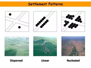
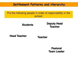
Patterns of Human Settlement. The Core/Periphery Model Land-uses. Where Canadians Live. Core/Periphery Model. C. C. C. B. B. B. A. A. C. C. B. A. C. Circle: 3 Large Cities ( A ), 3 Towns ( B ) and 3 Small Towns or Villages ( C ). A. B. C. C. B. C. C. B. C. C. Circle:

Patterns of Human Settlement
E N D
Presentation Transcript
Patterns of Human Settlement The Core/Periphery Model Land-uses
C C C B B B A A C C B A C Circle: 3 Large Cities (A), 3 Towns (B) and 3 Small Towns or Villages (C)
A B C C B C C B C C Circle: 1 Large City (A), 2 Towns (B) and 3 Small Towns or Villages (C)
Type: Looks Like… Bigger houses w/ green space surrounding (lots) Small, tightly packed houses, town houses and small apartments Apartment buildings, condos, high-rise towers • Low Density… • Medium Density… • High Density… Types of Land-use: Residential
Type: Looks Like… Corner stores and strip malls. Small malls, big box stores and small office buildings. Big malls, big box clusters, office towers. • Low Order… • Medium Order… • High Order… Types of Land-use: Commercial
Type: Looks Like… Open lots or storage yards/warehouses, near transportation: sea, rail, road or air. Small to large factories and warehouses, usually clustered together. Central processing area surrounded by resources to be collected, connected to transportation. • Transportation / Distribution Hub… • Manufacturing… • Resource Gathering / Agriculture… Types of Land-use: Industrial
Resource gathering (quarry) Agricultural
Getting an Idea of What Your Neighbourhood Looks Like… Go to Google Maps and print a picture of your neighbourhood (school, dorm or local residence). Be sure to remove the bar on the left before you print. Make a composite map of 2 pieces (2 parts that go together) using the 200m scale. Show the different land-uses in your map by shading over it, using different colours. Use the same colour for the same type of land-use and use lighter/darker shades to show different levels. You may use pencil crayons, transparent markers or digital imaging to create your map.
What is the most common land-use in your town? • What is the most common level of residential density in your neighbourhood? • What is the most common order of commercial development in your neighbourhood? • Are there any industrial activities in your neighbourhood? If so, what are they? Questions: