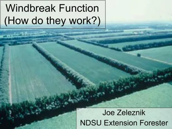
How Are Cities Organized, and How Do They Function?
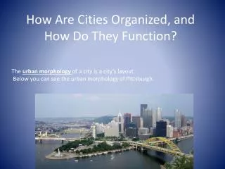
How Are Cities Organized, and How Do They Function?. The urban morphology of a city is a city’s layout. Below you can see the urban morphology of Pittsburgh. . Urban Land Use in North America/Europe. Concentric Zone Model. Indianapolis, Indiana. Concentric Model .

How Are Cities Organized, and How Do They Function?
E N D
Presentation Transcript
How Are Cities Organized, and How Do They Function? The urban morphology of a city is a city’s layout. Below you can see the urban morphology of Pittsburgh.
Urban Land Use in North America/Europe Concentric Zone Model
Indianapolis, Indiana Concentric Model
The Sector Model (Homer Hoyt) • Result of physical characteristics (hill, water) • Focuses on residences • tends to fit “newer” cities
Multiple-Nuclei Model • Based on the idea that cities have multiple nodes (these nodes may be different functions for a city • Nodes may be ports, airports, CBD’s, Univers- ties • Better fit for more modern cities
Latin American City Model Fig. 13-15: In many Latin American cities, the wealthy live in the inner city and in a sector extending along a commercial spine.
Mexico City Fig. 13-12: The Aztec city of Tenochtitlán was built on an island in Lake Texcoco. Today poorer people live on a landfill in the former lakebed, and the elite live to the west.
Squatter Settlements Unlike North American cities, the inner core of South American cities has, until recently, remained vital and of greater social standing, the periphery relegated to poverty, decay and crime. Sprawl, facilitated by buses, has extended the limits of cities.
Torre de David, Caracas Torre de David is an example of how squatter settlements on the periphery of Caracas are so packed that people are moving, and squatting, in the CBD! This also shows how important political considerations are in determining the ability of people to establish squatter settlements.
Latin America - Inner City Trends • A flight of the rich to the spines and to the gated suburbs has left mansion homes in areas adjacent to the central business district (CBD) • Frequently, these have been converted into rented tenements – multi-family apartment buildings in which several whole dwellings will be carved out of a single room • These then become the shanty-towns of the inner-urban poor, those working as street vendors or in low-paying service jobs in and around the towering commercial buildings of the next door CBD. • These types of changes create zones of disamenity which are neglected by the city authorities and exploited by the landlords.
Squatter/Shanty Towns • Every South American city has them – usually on the edge of town outside the ring road, often on steep slopes or along river corridors subject to periodic flooding. • So common are the squatter areas that almost every country in South America has its own term for them – favelas, villas miserias, pueblos jóvenes, cerrosandquebradas, barrios and so forth. • Depending on the country and city, shanties may contain more than half of the urban population, although 20-30% is a more common figure. • In some situations, rapid growth of cities has led to shanties filling in underutilized space (for example steep unstable slopes) inside the sprawling metropolises, creating stark juxtapositions.
Squatter settlements – Highly Variable Zones • They are characterized more by the fact that the land they occupy has no title – the communities are squatting on (usually) public or ejidal lands – than the nature of the dwellings. • Depending on age, they can range from sprawling collections of hastily constructed shacks of scavenged materials to more orderly, multi-room brick or cement panel buildings, often with rebar or wood scaffolding sticking out of a flat roof - evidence of permanency, or at least ambitions of such.
Characteristics of Shantytowns • Population densities are high, families living in close proximity to each other on small parcels of land. • Privacy is very limited, with minimal separation between households in both a geographical and physical sense. • Basic services are usually absent especially garbage collection, sanitary sewer service, telephone and piped potable water supply, although basic electricity service might be provided (often with many illegal connections). • Roads are usually unpaved, with no formal surface drainage to conduct surface runoff safely off the roads and down hillsides, leading to extensive erosion. • Garbage is usually burned in oil drums or pits and open-air defecation is common, thus development projects frequently promote pit-latrine projects in shanty towns.
Caracas, Venezuela – This picture could be from anywhere in Latin America!
To summarize: Squatter settlements are most likely located: • On the edge of the metro area on either public or private land which was unoccupied prior to the establishment of the squatter settlement. • On steep hillside areas either at the edge of the city or in the center, which were thought to be un-buildable or unoccupied before the squatters established themselves. • On dump sites in the city • On areas that are prone to flooding • Lands that have unclear title
Factors that have resulted in the high proportion of squatter settlements • Large scale and rapid rural to urban migration resulting from push factors. For ex: changing nature of agriculture • Lack of employment opportunities in rural areas. • Inability of government to provide enough public or subsidized housing to meet the demand. • Undeveloped housing sector of the economy to provide financing, labor, property and development expertise to build large areas of low cost housing in the private sector. • Rapid population growth within the squatter population in the large cities.
Consequences of Rapid Growth • Large numbers of people working in informal sector of the economy. • Unhealthy living conditions and high sickness and mortality rate in squatter settlement. • Development of strong anti-gov’t or authority political parties or branches of political parties. • Development of gangs, mafias, or other non-legal authority systems in the squatter settlements that use violence to enforce their rule. • Increased police corruption.
Consequences of Rapid Growth (cont.) • Increased soil erosion on hillsides as existing vegetation is removed for housing. • Increased water pollution resulting from lack of sanitary facilities in squatter settlements. • Decreased air quality resulting from fires used for cooking and heating in settlements. • Social, health issues, such as increased drug use, limited access to fresh water, children not attending school. • Strain on infrastructure, illegal access to • electricity out of necessity.
Rio de Janeiro, BrazilHigh & Low Income Regions Fig. 13-16a: High income households in Rio de Janeiro live in the CBD and in a spine along the ocean. Low-income households often live in peripheral areas.
Rio de JaneiroAreas with Sewers Fig. 13-16b: High income households are attracted to central areas of Rio partly because these areas have access to services such as sewers.
Fès (Fez), Morocco Fig. 13-13: The old city in the east has narrow winding streets and dense population. The French laid out a new district to the west with a geometric street pattern.
Ho Chi Minh City, Vietnam Fig. 13-14: In Ho Chi Minh City (formerly Saigon), the French demolished the previous city and replaced it with a colonial design with boulevards and public squares.
Social Areas in Paris Fig. 13-11: Higher income professionals are likely to live in the center of Paris, while factory workers tend to live in the suburbs, in contrast to the pattern of many American cities.
St. Louis Metropolitan Area Fig. 13-3: The metropolitan area of St. Louis is spread over several counties and two states. It is also a diversified trade center, due to its position on the Mississippi River.