Download
1 / 36
730 likes | 1.6k Vues
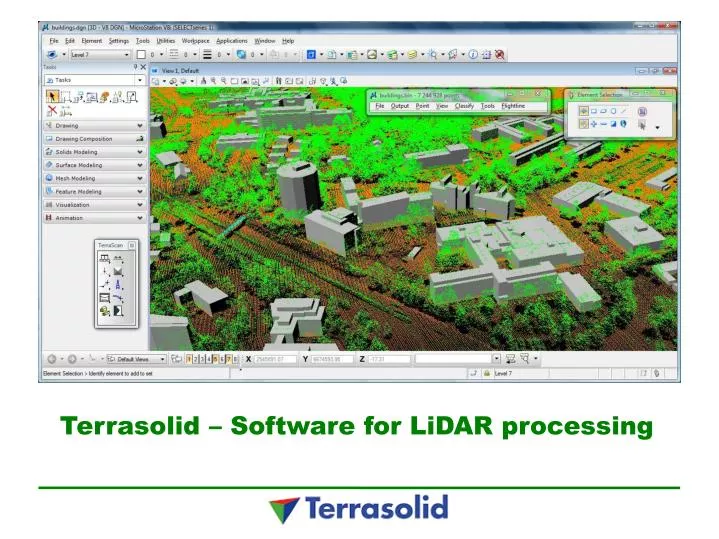
Terrasolid – Software for LiDAR processing. Terrasolid Ltd. Founded in 1989, privately held 25+ years of software development on MicroStation 15+ years of point cloud software development Last fiscal year revenues 4,5 M€ Based in Finland. Terrasolid Ltd. Over 4000 TerraScan licenses sold

E N D
Terrasolid Ltd. Founded in 1989, privately held 25+ years of software development on MicroStation 15+ years of point cloud software development Last fiscal year revenues 4,5 M€ Based in Finland
Terrasolid Ltd. Over 4000 TerraScan licenses sold Customers in over 90 countries Global market leader in airborne and mobile laser scanned point cloud processing with an estimated 85% market share Bentley Platform Partner Agreement
Terrasolid products LiDAR processing TerraScan TerraMatch TerraPhoto TerraModeler TerraSurvey
Platforms MicroStation V8i SS2/SS3 or V8 2004 Edition Bentley Map Bentley Map PowerView Bentley PowerCivil
What do you do with Terrasolid's applications? After the flight or drive the point clouds are pre-processed with the hardware vendors specific application After that the point clouds are calibrated and the precisioon is improved with Terra applications Once calibrated you can produce different feature extractions such as automatic building vectorization
LiDAR processing Import RAW laser data and trajectories Calibrate and align point clouds from multiple flightlines Classify the points with rules Process airborne images and produce orthos Produce delivery products • Surfacemodels with breaklines • Accurate 3D road and bridge models for design purposes • Contours • Building models • Trueorthos • Digitized transmission powerlines for efficiencycalculations • Digitized transmission lines for vegetationmaintenance • Floodmodels • etc…
TerraScan Read the points into the correct coordinate system Divide the points into blocks
TerraScan Classify the points by flightline
TerraMatch Match the multiple flight passess by tie lines Tie to ground control Before matching the flight lines After matching the flight lines
TerraScan Point classification Ground Vegetation by height from ground Buildings Model keypoints Manual editing
TerraPhoto Create and rectify ortho mosaic TrueOrtho-production Supports the point classification process Laser point coloring Building wall texturing from oblique images Visualizations and animations
TerraPhoto Draping an ortho on to the ground
High density airborne point cloud 20 points / m2
TerraScan Automatic building vectorization
33 km wide 51 km high 3 billion points Automatic building classification Automatic building vectorization 72,000+ buildings 6 hours vectorization
Rectify / Wall rasters Creates visualization rasters for walls First version produces reasonable results from oblique airborne images
Survey grade 3D models of railroad corridors with mobile LiDAR mapping
Mobile LiDAR mapping • GPS / IMU location/orientation • 2 rotating LiDAR sensors • Up to 1,000,000 points/second • Multiple cameras • Data collection at highway speeds • Very accurate, efficient and safe surveying method
Georeferencing the point cloud • The initial precision of the point cloud is poor due to only relying on GPS/IMU • Ground signaling is needed to achieve survey precision • A fluctuating correction is applied to the point cloud to meet the ground control measurements • Resulting point cloud location precision is 2-3 centimeters
Point cloud classification Raw point cloud Classified point cloud Colored point cloud
Geometry Component Fitting Finds design geometry built from lines, arcs and clothoids which best match surveyed alignment of a road or a railroad Fitting for both horizontal and vertical geometry Goals: View current geometry of road/railroad/pipeline in design software such as Bentley InRoads, Bentley Track etc passing geometry as LandXML file or similar Is curvature right for this category of road? Do component changes follow design principles? Find long span deformations
Horizontal Geometry Fitted components Fitted components and differences to survey Surveyed alignment Exaggerated difference
Summary • - Mobile LiDAR is the mostefficient, safe and costeffectiveway to surveyrailways • The resulting point cloud is a precise 3D model of the railwaycorridor • It is possible to vectorizefeatures and populateyourasset management system • Youcanautomaticallyvectorize the rails and overhangingwires and with component fittingobtain the railgeometry in design format