Exploring Mapping History and Navigation Techniques in Geography
Dive into the fascinating world of mapping and navigation throughout history! This content covers essential themes like regions (functional, prime meridian), early mapping civilizations (Babylonians, Ptolemy), navigation devices (astrolabe, sextant), and the notable contributions of figures such as Magellan and Eratosthenes. Through engaging trivia format reflecting Jeopardy! style questions, explore the key advancements in cartography, challenges faced by early navigators, and the evolution of geographical knowledge. Perfect for geography lovers and history buffs alike!

Exploring Mapping History and Navigation Techniques in Geography
E N D
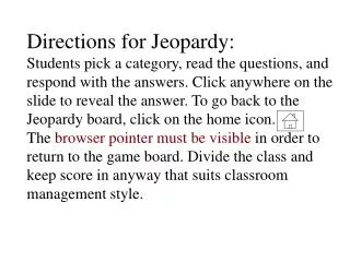
Presentation Transcript
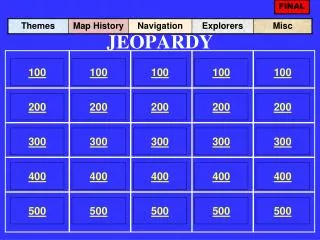
FINAL JEOPARDY 100 100 100 100 100 200 200 200 200 200 300 300 300 300 300 400 400 400 400 400 500 500 500 500 500
Themes for 100 What type of Region includes one central place and the surrounding areas affected by it Functional Region Push the Space Bar to check your answer.
Themes 200 What is the line that is located at 0º Longitude Prime Meridian Push the Space Bar to check your answer.
Themes 300 What are the imaginary lines used to measure distance North and South of the Equator Latitude Push the Space Bar to check your answer.
Themes 400 Half of the Globe is called ….. Hemisphere Push the Space Bar to check your answer.
Themes 500 Name of the Line at 180º Longitude International Date Line Push the Space Bar to check your answer.
Map History 100 The first known maps were created by which ancient civilization Babylonians Push the Space Bar to check your answer.
Map History 200 What was the name of the Greek philosopher who created 8 volumes of work titled Geography Ptolemy Push the Space Bar to check your answer.
Map History 300 During the Middle Ages, the center of maps was often occupied by what city? Jerusalem Push the Space Bar to check your answer.
Map History 400 What role did science play during the Middle Ages None, it was a time dominated by religious belief Push the Space Bar to check your answer.
Map History 500 Magellan and his crew will forever be famous for being the first to do what Circumnavigate the globe, (even without Magellan finishing the trip) Push the Space Bar to check your answer.
Navigation 100 Ptolomy created this device to assist with navigation Astrolabe Push the Space Bar to check your answer.
Navigation 200 What was the problem with the Cross Staff Caused sailors to go blind lining up the angles Push the Space Bar to check your answer.
Navigation 300 A compass will always face which direction? Magnetic North Push the Space Bar to check your answer.
Navigation 400 What was Columbus looking for when he set sail to the West Westward water path to India/Far East Push the Space Bar to check your answer.
Navigation 500 A device for navigation that can measure up to 60º Sextant Push the Space Bar to check your answer.
Early Mapping 100 The oldest known map comes from the Babylonians at approx what date 2300 BCE Push the Space Bar to check your answer.
Early Mapping 200 The earliest Egyptian Maps were from what date 1300 BCE Push the Space Bar to check your answer.
Early Mapping 300 What was the name of the Roman citizen who was Greek, living in Egypt, who unlike most Romans was very interested in land outside the Roman Empire Ptolomy Push the Space Bar to check your answer.
Early Mapping 400 What were the two big mistakes Ptolomy’s made While creating a “map” of the Land masses too big and oceans too small – produced a globe that was 18,000 miles round at the Equator rather than the 25,000 miles it actually is. Push the Space Bar to check your answer.
Early Mapping 500 In the Middle ages, what was used to display wind Gods/Fairies/etc Push the Space Bar to check your answer.
Misc 100 Navigation device that worked well, but caused blindness to its users Cross Staff Push the Space Bar to check your answer.
Misc 200 Type of map that is used by navigators while sailing on the sea Portolan Maps Push the Space Bar to check your answer.
Misc 300 Both Stick maps and portolan maps display this information Wind Patterns Push the Space Bar to check your answer.
Misc 400 Produced maps that displayed everything between 60°N and 60°S accurately, but outside of those lines was distorted Mercator Push the Space Bar to check your answer.
Misc 500 Estimated the earth to be round, and was almost exact as to its size (he was greek) Eratosthenes Push the Space Bar to check your answer.
FINAL JEOPARDY People Name the 4 items Ptolomy contributed t the world of mapping • Scale • Long/Lat • Geography (the word) • Projections Push the Space Bar to check your answer.