Mapping Faunal Similarities of Native Fishes in Various U.S. Drainages
80 likes | 205 Vues
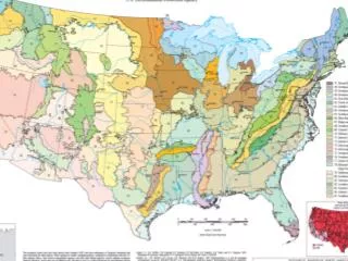
This analysis presents the average faunal similarities of native fish species across multiple U.S. drainages, including Upper Red and Eastern Oklahoma, parts of the Atchafalaya, Lower Mississippi, Lower Red, and Eastern Louisiana. Key breaks in these basins are identified, with the Colorado and Brazos Rivers noted as transition zones exhibiting characteristics of both eastern and western drainages. Uncertainty in suggestions for certain Oklahoma areas is acknowledged. For visual reference, a map of the WWF freshwater ecoregions is provided.

Mapping Faunal Similarities of Native Fishes in Various U.S. Drainages
E N D
Presentation Transcript
Upper Red and most of Oklahoma (?) Eastern OK (?) Atchafalaya, Lower Miss, Lower Red, and Eastern LA Drainages Mermentau This shows average faunal similarities of native fishes in the basins. I’ve circled what I believe the best breaks to be. The Colorado and Brazos are really a transition zone, with lower reaches being more like drainages to the east, and the upper reaches resembling the west. Question marks are on my OK suggestions because I’m not as familiar with that area Here is a map of the WWF FW Ecoregions. http://www.feow.org/index.php