Download
1 / 18
180 likes | 336 Vues
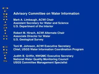
Advisory Committee on Water Information Mark A. Limbaugh, ACWI Chair Assistant Secretary for Water and Science U.S. Department of the Interior Robert M. Hirsch, ACWI Alternate Chair Associate Director for Water U.S. Geological Survey Toni M. Johnson, ACWI Executive Secretary

E N D
Advisory Committee on Water Information Mark A. Limbaugh, ACWI Chair Assistant Secretary for Water and Science U.S. Department of the Interior Robert M. Hirsch, ACWI Alternate Chair Associate Director for Water U.S. Geological Survey Toni M. Johnson, ACWI Executive Secretary Chief, USGS Water Information Coordination Program Judith B. Griffin, NWQMC Executive Secretary National Water Quality Monitoring Council USGS Committee Management Specialist Organization Charts
Advisory Committee on Water Information Subcommittees National Water Quality Monitoring Council National Liaison Committee for NAWQA ٭Subcommittee on Spatial Water Data Subcommittee on Sedimentation Work Groups Methods and Data Comparability Board Subcommittee on Hydrology Sustainable Water Resources Roundtable Work Groups Work Groups Work Groups * Also reports to Federal Geographic Data Committee
Work Groups Reporting October 2006 Proposed National Water Quality Monitoring Council GroundWater Monitoring * Spatial Water Data Hydrology Methods and Data Comparability Board Hydrologic Unit Delineation Task Group on Hydrology Modeling Water Information Strategies Standards Hydrologic Frequency Analysis Collaboration and Outreach New * FGDC Wetland Mapping Standard National Monitoring Network Steering Comm. + Satellite Telemetry * Also Reports to Fed Geog Data Comm. + AlsoReports to Fed Coord for Meteorology
Proposed Subcommittee on Ground Water Monitoring Assure ground water receives the monitoring & assessment attention that it deserves, given its importance for water supply and the sustenance of ecological, riverine, lacustrine, estuarine, and coastal resources. Develop a consistent, nationwide monitoring & assessment program leading to an accurate estimation of stored volume, availability, & sustainability across the U.S.
Actions for ACWI Proposed Subcommitteeon Ground Water Monitoring • Request ACWI Feedback on focus and scope of subgroup, in particular about: • Including Water Quality as well as Quantity • Specifying Relationship to NWQMC
Subcommittee on Hydrology Improve the availability & reliability of surface water quantity information needed for hazard mitigation, water supply and demand manage- ment, & environmental protection.
Satellite Telemetry Interagency Working Group (STIWG) The STIWG user group for the Geostationary, Operational Environmental Satellite (GOES) Data Collection System (DCS)advises NOAA’s National Environmental Satellite Data and Information Service (NESDIS) on matters concerning satellite data relay user requirements for hydrologic, meteorologic, oceanic, and environmental data & promotes current information exchange among agencies to benefit the GOES DCS community.
Actions for ACWI Subcommittee on Hydrology Satellite Telemetry Interagency Working Group (STIWG) Seek ACWI support for the STIWG Proposal to: • Improve the reliability of GOES DCS to assure availability of data. • Revive an involved STIWG partnership with NOAA in the strategic planning process of the DCS portion of GOES and the DCS Automated Processing System (DAPS). • Reclassify the GOES DCS from an ancillary to a primary system status within NOAA priorities.
ACWI ACTION ITEM RE GOES/DCS At the ACWI Interim Meeting, October 4, 2006, the Satellite Telemetry Interagency Working Group (STIWG) gave a presentation on several issues related to NOAA’s support of the GOES DCS. Because ACWI agrees that the GOES DCS is such a critical system for collecting real-time environmental data, the ACWI requests that the appropriate NOAA senior management meet with representatives of the STIWG, develop a collaborative strategy to address these issues, and provide a summary of this strategy at the next ACWI meeting (January 17-18, 2007).
National Water QualityMonitoring Council Provide a national forum for coordination of consistent & scientifically defensible methods and strategies to improve water quality monitoring, assessment & reporting. Promote partnerships to foster collaboration, advance the science, & improve management within all elements of the water quality monitoring Community.
National Monitoring Network Develop a National Monitoring Network that coordinates and expands existing efforts, includes coverage in both coastal waters & the upland areas that affect them, and is linked to the Integrated Ocean Observing System (IOOS).
Actions for ACWI National Water Quality Monitoring Council National Monitoring Network • We anticipate that ACWI, through the NWQMC, will continue to provide oversight, guidance and support toward the implementation of pilot efforts. • The Network Steering Committee will continue to work with the Office of Science and Technology Policy, and the Interagency Working Group on Ocean Science and Integrated Resource Management (ICOSRMI).
Subcommittee on Spatial Water Data The Subcommittee – reporting jointly to the Federal Geographic Data Committee – develops water resources components of the National Spatial Data Infrastructure.
Wetland Mapping Standard A newworkgroup of the Federal Geographic Data Committee (FGDC):– To develop and finalize a national standard for mapping wetlands at multiple time-frames. -- To facilitate mapping by various entities and integrate data into the NWI Geodatabase and delivery to the National map.-- To ensure consistency in updating wetlands maps while preserving availability of older, historic, baseline wetlandsmaps for changeassessment.
Upcoming ACWI Annual MeetingJanuary 17-18, 2007 • ACWI 2007 Annual Meeting Highlights • Full two days • Presentations from all 8 Subgroups • Report from NOAA on GOES/DCS • Ground Water Monitoring Terms of Reference • Special Presentations and Panel Discussions that are of interest to ACWI members – for which we welcome your suggestions. • ACWI 2007 Membership renewal process
Renewal Application Procedure All ACWI Member Organizations must be renewed or new nominations prepared by March 30, 2007 for approval by Secy of Interior prior to Nov. 1, 2007 • Existing member organizations who wish to renew will be requested to send a signed letter. • Identify whether current Rep/Alt will continue, or wish to nominate replacements? • Each identified Rep & Alt must complete Interior’s nomination form and attach brief resume. • Nominations for new organizations to fill vacancies will be solicited from Fed and non-Fed ACWI members, and via Federal Register Notice.
Interim Meeting October 4, 2006 Thank you for your active participation. We hope you find the information shared today to be beneficial to you and to the organizations you represent.