Download

1 / 19
210 likes | 368 Vues
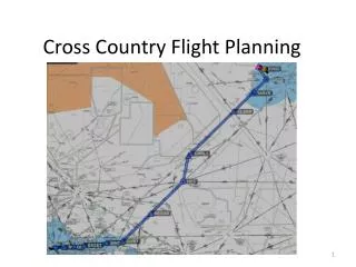
Flight Planning. Plan the flight, fly the plan. Technique. 1. Plot Course a. Get true course b. Select checkpoints (9 – 22nm) c. Start nav log 2- Weather briefing a. Go/no-go decision b. Adjust route if necessary c. Select altitude 3- Performance Calculations a. Wt/Bal

E N D
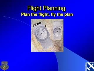
Flight Planning Plan the flight, fly the plan
Technique 1. Plot Course a. Get true course b. Select checkpoints (9 – 22nm) c. Start nav log 2- Weather briefing a. Go/no-go decision b. Adjust route if necessary c. Select altitude 3- Performance Calculations a. Wt/Bal b. Takeoff/ldg dist c. Time/fuel/dist to climb d. Time/fuel in cruise e. Complete nav log 4- File if desired and execute
Plot Course • Using your plotter, draw a line from center of departure point to center of destination airport • Look for hazards along your route • Special Use Airspace • Terrain • Large bodies of water • Adjust course if necessary • Find your true course • Lay plotter down with top edge along route • Place center on a line of longitude • Read true course on East or West scale • Mark mileage in 5 or 10 mile intervals on your route • Example: SBN to SMD (Smith Field in Fort Wayne)
Checkpoint Selection • What makes a good checkpoint? • Precision • An intersection of two roads is more precise than the point where your course is supposed to intersect a road • Visibility • Radio towers make poor checkpoints because they are difficult to see from the air • Airports make great checkpoints because they are very easy to see from the air • Distinctiveness • Using a lake as a checkpoint when flying across New Mexico makes sense • Using a lake as a checkpoint when flying across east Texas increases your odds of mistakenly identifying your checkpoint
Checkpoint Selection • Selecting the first checkpoint • Should be within 5-10 miles of departure point • Establishes your initial heading as correct • Additional checkpoints • Select additional checkpoints every 9 – 22 miles thereafter • Example: • I chose the following checkpoints: • Golden Dome / Basilica (initial point) • Bypass road south of Elkhart • Syracuse • Merriam
Weather Briefing • Get a weather briefing from an official source • 1-800-WX-BRIEF • DUAT or DUATS • Make a go/no-go decision • “VFR flight not recommended” • Conditions beyond your ability • Winds • MVFR or IFR clouds and weather • Convective activity • Precipitation • Adjust route if necessary • Select altitude • Winds Aloft will inform this decision
Performance Calculations • Weight and Balance • Weight information will be required for performance calculations • Example: Assume max gross weight • Takeoff / Landing distance • Ensure your aircraft is capable of making it out of your departure airport and in/out of your destination airport
Performance Calculations • Time / Fuel / Distance to Climb • Cessna charts make this calculation very simple • Take value at your cruise altitude and subtract value from departure pressure altitude • Make approximations as appropriate • There is no need calculate to a level of precision beyond what is given in the chart • Therefore, find: • Time to the nearest minute • Fuel to the nearest tenth gallon • Distance to the nearest mile
Performance Calculations • Time / Fuel / Distance to Climb Example • Climb from SBN (799 ft) to 4,500 ft • Weather: • SBN 07010G15 10SM CLR 13/M02 A2997 • Approximations • Difference between pressure alt. & true alt is 50 feet, negligible • Difference between SBN elevation and 1000 foot entries is negligible • Values for 4,500 feet (by interpolation) • Time: 7 min • Fuel: 1.7 (conservative estimates dictate rounding up) • Distance: 10 miles (only valid in zero wind) • Values for 1,000 feet • Time: 1 min • Fuel: 0.4 gal • Distance: 2 miles • Climb totals • Time: (7 – 1) = 6 minutes • Fuel (1.7 - .4 ) = 1.3 (+ 1.1 for tax & takeoff) = 2.4 gal • Wind is nonzero, so note avg climb speed: 76 knots
Performance Calculations • Before we can complete nav log, we need to find our top of climb (TOC) & top of descent (TOD) points • Procedure • Use Winds Aloft to find groundspeed • Use time-to-climb to find distance • Example • Winds Aloft 3000 6000 FWA 0416 3615 • For climb, use winds at 3000 • Interpolate: winds at cruise altitude (4,500) are 020 at 16
Performance Calculations • E6-B • Turn to wind side • Set wind direction (040) opposite true index • Mark wind velocity (16) up from grommet • Set true course (123) opposite true index • Slide the TAS arc (76) under the wind dot • Read ground speed under grommet (72) • Read wind correction angle at wind dot (12 deg left)
Performance Calculations • Top of Climb point • Turn to computer side of E6-B • First question: How fast? • 72 (our calculated groundspeed for the climb) • Earlier, we computed the climb would take 6 minutes • Read distance (7.2) above minute (6) scale • For the mathematically astute, 6 minutes is 1/10 of an hour, so the TOC distance is a tenth of our groundspeed
Performance Calculations • Top of Descent point • Figure a 500 foot per minute descent • From 4500 to 1800 (Traffic Pattern Altitude at SMD) is a 2700 foot descent, or 5.4 minutes • 130 knots is a good descent airspeed in the 172 • Use same winds (040 at 16) • Flip to wind side of E6-B • Wind dot is still valid; slide up to 130 knot TAS arc • Read groundspeed under grommet (127) • Read WCA under wind dot (7 deg left) • Flip to computer side of E6-B • How fast? • 127 knots • Read descent distance (11.5 miles) over descent time (5.4 minutes)
Performance Calculations • Check cruise performance to find TAS and GPH en route • Plan on max continuous power setting (75% BHP) • Temperature is standard • 500 foot difference on performance chart is negligible • Use 4000 foot data • KTAS is 114 knots • GPH is 8.6
Complete Nav Log • Measure distances between each checkpoint • Don’t forget to factor in your TOC and TOD points • Fill in each checkpoint and leg distance • Compute cruising groundspeed • Find cruising wind correction angle • Apply magnetic variation • Find ETE between checkpoints • Find fuel consumption between checkpoints
Complete Nav Log • Example: Find cruising ground speed • (Previously interpolated) winds are 020 at 16 • Go to wind side of E6-B • Set wind direction (020) opposite true index • Mark wind velocity (16) up from grommet • Set true course (123) opposite true index • Slide TAS arc (114) under wind dot • Read groundspeed under grommet (116) • Read WCA under wind dot (8 deg left)
Complete Nav Log • Apply WCA to True Course • -L, +R • Apply magnetic variation • A check of the sectional indicates one isogonic line along route of flight, +5 deg W • -E, +W (East is least, West is best) • Result is magnetic heading • This is as far as we can go until we look at the compass card in the aircraft
Complete Nav Log • Example (cont) • Find ETE between checkpoints • Already computed ETE (6 min) and fuel consumption (2.4 gal) to TOC point • Fill values in on nav log • Flip to computer side of E6-B • How fast? 116 knots • Read ETE underneath distance • Round off to nearest minute • Find fuel consumption between checkpoints • E6-B • How fast? 8.6 GPH • Read fuel consumed over minutes scale • Round to nearest tenth gallon • Subtract en route fuel from total • Assume a full fuel load (53 gal)