9 km Long P-Wave Reflection Profile Analysis of Lepanto, Arkansas (2006)
This report presents preliminary data from a 9 km long P-wave reflection profile acquired between May 9-19, 2006, near Lepanto, Arkansas. Utilizing a Thumper Minivibe I P-wave source, the data reveals insights into the geological formations along the Mississippi River, specifically in Quaternary, Tertiary, Cretaceous, and Paleozoic strata. With a focus on raw seismic data filtered for specific frequency ranges, this study contributes to understanding subsurface conditions and geological evolution in the region. The processing involved includes AGC, BP filtering, and vertical exaggeration for clearer visualization.

9 km Long P-Wave Reflection Profile Analysis of Lepanto, Arkansas (2006)
E N D
Presentation Transcript
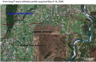
9-km long P-wave reflection profile acquired May 9-19, 2006 Seismic profile location Mississippi Lepanto, Arkansas Marked Tree, Arkansas River
Lepanto, Arkansas – May 2006 (m) Thumper Minivibe I p-wave source Raw data from 3 miles west of Lepanto, Ar, except for BP filter 15-30-80-120 Hz, 200 ms AGC
Preliminary Data Lepanto, Arkansas – May 2006 Downtown Lepanto bridge West East Little River bridge Quaternary Tertiary Cretaceous Paleozoic Preliminary Data – No Peer Review 1 km 4:1 vertical exageration Thumper Minivibe I p-wave source – Stk 5, precorrelation AGC 200 ms, prestack BP filter 15-20-90-120 Hz, 60 Hz notch, surface wave mute, single fn estimate nmo 30% stretch, rstat1, post stack fx decon, bp filt 20-30-90-120, 1-9-07