Download
1 / 41
410 likes | 516 Vues
Discover the diversity of landforms around the world, from majestic mountains and winding canyons to serene lakes and vast plateaus. Learn about the unique features of archipelagos, bays, fjords, and much more.

E N D
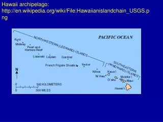
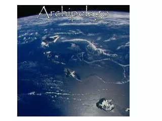
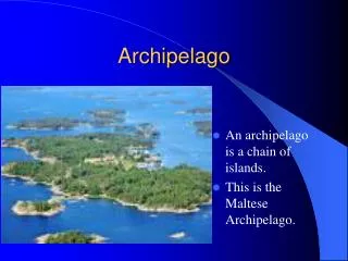
Archipelago • An archipelago is a chain of islands. • This is the Maltese Archipelago.
Basin • A river basin sends all the water falling on the surrounding land into a central river and out to a larger body of water like the Ocean or the Gulf of Mexico.
Bay • A bay is where a larger body of water protrudes into the mainland. • These are the Radical and Balding Bays of Magnetic Island.
Bight • Bight is another name for an open bay. • This is the Great Australian Bight
Canal • A canal connects two larger bodies of water. • They can be for transportation or irrigation. • The top picture is the Panama Canal which is used for transportation.
CANYON • A canyon is a deep valley between cliffs often formed by a river. • This is a picture of the Grand Canyon in Arizona.
Cape • A cape is a narrow strip of land that sticks out into a larger body of water. • This is a Cape Cod in Massachusetts.
Channel • A channel is any deeper route through shallower water. • This is a picture of the English Channel.
Cliff • Cliffs are nearly vertical rock exposures • The top photo is a cliff diver in Hawaii. • The bottom photo is the White Cliffs of Dover in England.
Coast • The coast is the area of land adjacent to the water. • This is the coastal village of Champania, Italy.
Current • A current is the directed movement of water within a larger body of water. • These are ocean currents of the coast of Australia. • Remember Nemo!
Delta • A Delta is where a river deposits land as it enters a larger body of water. • Top photo is the Nile River Delta. • Bottom photo is the Mississippi River Delta.
Divide • A ridge of land between two river basins • This is a picture of The Great Divide in Wyoming.
Estuary (Mouth of a River) • An estuary is where the river meets the sea. • Sometimes called a bay, sound, or fjord. • This is a picture of the Chesapeake Bay estuary.
Fjord • A fjord (or fiord) is a long, narrow estuary with steep sides, made when a glacial valley is flooded by the sea. • These are fjords in Norway.
Glacier • A glacier is a large, slow moving river of ice, formed from compacted layers of snow. • Glacier ice is the largest reservoir of fresh water on Earth. • Hubbard Glacier, Alaska.
Gorge • A gorge is another name for canyon. • This is the Royal Gorge in Colorado.
Gulf • A gulf usually refers to a large bay that is an arm of an ocean or sea. • For example, the Gulf of Mexico is the ninth largest body of water in the world.
Harbor • A harbor or harbour, or haven, is a place where ships may shelter from the weather or are stored. • Surrounded on most sides by land. • Smaller than a bay. • This is the Sydney Australia Harbor
Highlands • Highlands are an elevated or mountainous region. • They may be mountains, hills, or plateaus. • This is a picture of the Scottish Highlands.
Hills • A hill is generally somewhat lower and less steep than a mountain. • This is Connors Hills in Victoria, Australia.
Island • An island is any piece of land that is completely surrounded by water, above high tide, and isolated from other significant landmasses. • Small island by Fuji.
Isthmus • An isthmus is a narrow strip of land that is bordered on two sides by water and connects two larger land masses. • This is the Isthmus of Panama.
Lake • A lake is a body of water of considerable size contained on a body of land. • A vast majority of lakes on Earth are fresh water, and most lie in the Northern Hemisphere at higher latitudes.
Mountain • A mountain is a landform that extends above the surrounding terrain in a limited area. • A mountain is generally steeper than a hill. • A mountain usually has an identifiable summit. • Mount Everest in Nepal is the tallest mountain on Earth.
Mesa • A mesa is an elevated area of land with a flat top and sides that are usually steep cliffs. • Named after the Spanish word for table. • It is a characteristic landform of arid environments, particularly the southwestern United States.
Ocean • An ocean is a major body of salt water. • 5 Oceans? • Some people count the water around Antarctica as another ocean.
Peninsulas • A peninsula is a piece of land that is bordered on three or more sides by water. • A peninsula can also be a headland, cape, island promontory, bill, point, or spit. • Michigan has 2 peninsulas.
Plain • A plain is a large area of land with relatively low relief. • The Great Plains are the broad expanse of prairie and steppe which lie east of the Rocky Mountains in the United States and Canada. • This is part of the plain in Nebraska.
Plateaus • A plateau is a large highland area of fairly level land separated from surrounding land by steep slopes. • Mount Roraima is a plateau
Reef • A reef is a rock, sandbar, or other feature lying beneath the surface of the water yet shallow enough to be a hazard to ships. • This is part of The Great Barrier Reef near Queensland, Australia.
Reservoir • Reservoirs are usually man-made lakes that are created by dams that manage the water level. • They are used to collect and store water.
River • A river is a natural waterway that transits water through a landscape from higher to lower elevations. • The Danube River connects Hungary and Slovakia.
Sea • A sea is a large expanse of salt water connected with an ocean. • Sometimes a large, salt lake that lacks a natural outlet such as the Caspian Sea and the Dead Sea.
Seaway (Inlet) • An inlet is a body of water, usually seawater, which has characteristics of one or more of the following:bay, a cove, an estuary, a firth, a fjord,a geo, a sea loch or sea pea, a sound, or a yo-yo. • This is the St. Lawrence Seaway.
Strait • A strait is a narrow channel of water that lies between two land masses. • This is the Bering Strait that separates North America from Asia
Source • The source of a river or stream may be a lake, a marsh, a spring, glacier, or a collection of headwaters. • Usually begins in highlands. • Mississippi River source near Grand rapids Minnesota.
Swamp • A swamp is a wetland that features temporary or permanent inundation of large areas of land by shallow bodies of water (salt or fresh). • This is a freshwater marsh in Florida.
Tributary • A tributary is a stream or river which flows into a larger river, and which does not flow directly into a sea. • There are 18 major tributaries to the Mississippi River, including the Ohio River ,Big Muddy River, Missouri River, Illinois RiverDes Moines River, and the Skunk River in Iowa.
Valley • a valley is a depression with predominant extent in one direction. A very deep river valley may be called a canyon or gorge. • A U-shaped valley in Glacier Natl. Park, Montana.
Volcano • A volcano is an opening, or rupture, in a planet's surface or crust, which allows hot, molten rock, ash and gases to escape from below the surface.