Download
1 / 10
100 likes | 224 Vues
This update covers the current status of the West Virginia National Hydrography Dataset (NHD) Stewardship Program as of June 2010. The proposal for Year One has been submitted and approved, highlighting key players including the WV Office of GIS Coordination, NRCS, and USGS. The program focuses on establishing stewardship mechanisms, correcting known errors, and addressing areas of high change. Total funding of $50K is secured, fostering collaboration and participation from stakeholders. Feedback is encouraged for ongoing development.

E N D
The WV NHD Stewardship Program: June ‘10 Update Evan J Fedorko
Outline • Status • Year One Proposal • Players • Task 1: Stewardship program establishment and organization • Task 2: Editing of known errors • Task 3: High change area targeted editing (research) • Funding
Status • Memorandum of Understanding • Between WV Office of GIS Coordinator, NRCS and the USGS • Identifies two stewards: WVOGC (NHD), NRCS (WBD) • Identifies a technical lead: WVGISTC • Signed, sealed and delivered! • Year one proposal • Submitted and approved!
Year One Proposal • Players • WVOGC • West Virginia GIS Technical Center (Fedorko) • Natural Resource Analysis Center (Strager) • West Virginia Department of Environmental Protection (Daugherty) • West Virginia stewardship community
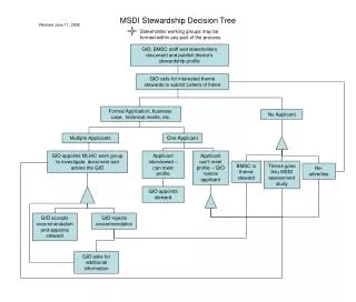
Task 1: NHD Stewardship Program USGS NHD Stewardship Program NHD National WV Office of GIS Coordination NHD Steward Stewardship Technical Lead WV GIS Technical Center NHD Error Reporting Tool Primary Sub-Stewards e.g., WVDEP, USFS, WVDNR Stakeholders and Stewardship Mechanisms NHD Training and Policies NHD Users Group NHD Data Users
Task 1 (cont.) • Establishment of ! • Establishment of Stewardship mechanisms, including: • Mailing list of updates • Error reporting tools • Training (also related to task 2) • What else? NHD Users Group
Task 2: Known errors • Utilize NRAC/WVDEP compilation of errors • NRAC and WVGISTC will edit as many 8 digit HUs as possible during project period
Task 3: High change areas targeted editing (research) • Work with WVDEP to develop methodology, data sharing mechanisms, etc., to most efficiently edit areas of high change; e.g. surface mining areas, road construction, etc.
Funding • Total funding is $50K - $25K from USGS matched by $25K from WV Office of GIS Coordination • Funding will be split between NRAC and WVGISTC
Discussion • We want your feedback and participation!