Download
1 / 15
150 likes | 341 Vues
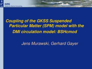
Coupling of the GKSS Suspended Particular Matter (SPM) model with the DMI circulation model: BSHcmod Jens Murawski, Gerhard Gayer. WP6: YEOS Sediment transport model. The development of a prototype of aYellow-Bohai Sea sediment forecasting system

E N D
Coupling of the GKSS Suspended Particular Matter (SPM) model with the DMI circulation model: BSHcmod Jens Murawski, Gerhard Gayer
WP6: YEOS Sediment transport model • The development of a prototype of aYellow-Bohai Sea sediment forecasting system • Task 6.5: Implementing and testing of the operational configuration of the GKSS-SPM model. • First steps: Coupling of the GKSS-SPM model with the DMI circulation Model BSHcmod. Tests of the SPM-BSHcmod in the North Sea and Baltic Sea.
Whats done? • Rewriting of the f77-SPM-subroutines to f90 language: SPM_module.f90. • Numerical Implementation of the GkSS-SPM model into the DMI circulation model. • Writing of Preprocessing skripts and tools to download and handle wave data. • Modification of existing scripts to run the coupled SPM-circulation model, including preprocessing. • First tests of the coupled SPM-circulation model in the North Sea / Baltic Sea using the operational setup provided by the GKSS.
Motivation, Features • Why? SPM is of particular importance for the eccosystem. It regulates the penetration depth of light and influences the nutrients concentration in the water column. • Where? The Suspendet Matter model is the collaborative development of the GkSS research center and the BSH (Gerhard Gayer et al. 2005). • Processes?The regional circulation model (cmod) was extended by an Suspended Particulate Matter module to include vertical exchange processes (sedimentation, resuspension and erosion), bottom processes (consumption and bioturbation) and the horizontal redistribution of SPM due to currents and waves. • Features? The new feature of the SPM model is the inclusion of wave effects into the description of the sediment dynamic. The SPM contribution of 79 rivers is included in the model. • 3 suspended matter fractions: wsink(frac1)=0.0001 m/s wsink(frac2)=0.00002 m/s wsink(frac3)=0.001 m/s
Modelled processes Shear Stress velocity sinking sinking transport vertical exchange vertical exchange 1. currents: sedimentation sedimentation transport 2. waves: resuspension Z1 = 0,…,1mm hero = 0,…,10cm erosion Z2 = Z1,…,10cm Bioturbation, diffusion Z3 = hero,…,10cm Z4 = 10cm
1 water column: SPM dynamic 2,08m 2,11m 0.000195 0.000191 0.000361 0.000365 From Sedimentation to Resuspension 0.000386 0.000391 0.000410 0.000417 0.000431 0.000440 0.000447 0.000460 0.000459 0.000475 0.000467 0.000485 0.000469 0.000490 0.000466 0.000489 0.000458 0.000485 0.000447 0.000478 Increasing wave height, constant currents 0.000445 0.000477 0.000046 0.0 0.000093 0.000098 6.65 6.65 6.65 6.65
Model domains and nesting no SPM const. bv SPM const. bv NEA: 24 nm, NS: 6 nm, BS: 1nm
Weather models Global,medium range:ECMWFRegional,short range: Hirlam4x/day
Wave model: WAM cycl. 4,Kitaigoroskii scaling 30 4x/day60h 6 x 10 1,2 x 2 6 1 10
79 rivers River Inflow q < 10 mg/l q > 10 mg/l Firth of Forth Scheldt 100 mg/l Wash 60 mg/l Humber 55 mg/l Firth of Forth 48 mg/l Elbe 38 mg/l Weser 35 mg/l Rhein 30 mg/l Humber Elbe Wash Weser Rhein Scheldt
Cliffs Constant mass Input rate at the Specified grid points in the English Channel (North Sea boundary) and at the Cliffs (Suffolk, Norfolk, Holderness) Holderness Norfolk Suffolk Suffolk 50 kg/s Norfolk 45 kg/s Holderness 58 kg/s English channel
First results: runtime 23 days longer forerun needed
Next steps • More and longer test runs in the North Sea. Comparrison of DMI model results with GKSS/BSH results. • Going to the Yellow sea: SPM bottom configuration map? River loadings (annual variability)? Const. coarse grid boundary values? • Validation data Yellow-Bohai Sea? • Data assimilation: Satellite information?