Census TIGER File Maintenance
Census TIGER File Maintenance. MARIS Briefing for MS State and Local DSL February 25, 2004 Chuck O’Hara. Project Overview. A congressionally-funded program to conduct research for the maintenance of Census TIGER file data.

Census TIGER File Maintenance
E N D
Presentation Transcript
Census TIGER File Maintenance MARIS Briefing for MS State and Local DSL February 25, 2004 Chuck O’Hara
Project Overview • A congressionally-funded program to conduct research for the maintenance of Census TIGER file data. • The project technical proposal was developed to establish and validate the use of high-resolution satellite image data for technologies to support the TIGER data maintenance program of the Bureau of Census. • Generate findings that motivate use of developed technologies by BOC, other federal agencies, and local government. • Perform necessary research to assure change detection and feature extraction capabilities provide results with needed accuracy, precision, and cost-effective characteristics.
Census TIGER File Maintenance Project The TIGER File Maintenance Project will validate the use of high-resolution satellite image data for land use change detection and feature extraction technologies that could provide support to the Bureau of Census TIGER data maintenance program.
Census TIGER File Maintenance Project The project will use enhanced multi-spectral remote sensing imagery for extracting features of interest for maintaining spatial feature databases to federal agencies [such as the Bureau of Census] as well as to state and local agencies for updating and maintaining their spatial databases.
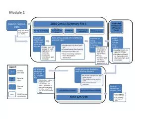
Census TIGER File Maintenance Project A benchmark example of accomplishing spatial database updates through improved technology use, the Bureau of Census TIGER Modernization Project employs spatial information technologies to significantly improve the nation’s important Census data. The Topologically Integrated Geographic Encoding and Referencing (TIGER) database will be modernized as part of a re-engineered 2010 Census. The five major objectives of the modernization project are to: 1) Correct locations of streets, other map features, and housing units; identify new streets/housing units using automated change detection methods (MAINTENANCE) 2) Develop/deploy a new MAF/TIGER processing environment based on COTS and GIS tools 3) Expand and encourage geographic partnership programs 4) Launch the Community Address Updating System (CAUS) 5) Implement periodic evaluation activities
Possible Partners Commercial high-res satellite image data product and services provider Commercial provider of mapping products and applications Employer of skilled GIS/image processing labor TIGER ProjectCommercial Partnership Interests MSU • Leading research & development institution attracting significant grants and project funds • Center of excellence for spatial technologies • Leading institution for developing advanced GIS/image processing skills
TIGER ProjectLocal and State Agency Partnership Opportunities • Identify counties with technology readiness, database availability, and desire to participate. • Identify Regional planning groups with desire and ability to assist in coordination between project and end user communities for end user needs analysis. • Identify state agency with technology readiness and desire to design, develop, and deploy methods for aggregating county data demonstration efforts at state levels as well as to National Map type framework.
TIGER ProjectTechnical Components • Project Design and Management • Data Acquisition • Technology Development • Validation and Verification • Systematization • Reporting and Demonstration • Needs Assessment • Outreach • Commercialization
TIGER ProjectDesign and Management • Finalize SOWs, Budgets, Milestones, and Timelines • Develop Needed Project Documentation • Conduct Regular (weekly) Conference Calls • Conduct Monthly Meetings w/ Status Reporting • Conduct Quarterly Meetings w/ Status Reporting, Full Expenditures, and Interim Products • Conduct Annual Meeting w/ Status Reporting, Full Expenditures, and Deliverables • Travel to Conferences and Meetings as Needed • Manage and Ensure the Timely Completion of Deliverables
TIGER ProjectData Acquisition • Select Study Sites • Acquire Image Data From Archives • Coordinate Field Data Acquisitions (Reference Segments) • Coordinate Basemap Data Exchange and Outreach • Task Acquisition of Revisit Images • Acquire Needed Private Vector Datasets (GDT) • Manage data, data exchange, and product development
TIGER ProjectTechnology Development • An object-based approach for feature classification • An integrated spectral/morphologic/multi-temporal approach for change detection • Development of data analysis tools for sharpening, fusion, benchmarking, verification and validation, and performance analysis. • Development of workflow management tools for managing, tracking, and analyzing status of project workflow tasks.
TIGER Project Technology Development • An object-based approach for feature classification. • An integrated spectral/morphologic/multi-temporal approach for change detection. • Development of data analysis tools for sharpening, fusion, benchmarking, verification and validation, and performance analysis. • Development of workflow management tools for managing, tracking, and analyzing status of project workflow tasks.
TIGER Project Validation and Verification • Develop tools to systematically arrive at objective, consistently derived measurements of the quality, accuracy, and precision of results. • Develop approaches that embrace and extend new field data acquisition methods to provide improved reference datasets to be used in V & V work. • Develop a suite of tools that can be used together to enhance and preprocess data, develop improved intermediate products, enhance data workflows, and facilitate benchmarking of workflow tasks against traditional techniques.
TIGER Project IV&V Software Suite • Horizontal Accuracy: CE90 Toolkit • Feature Identification: Pan Sharpening and Image Quality Interface • Feature Extraction: Linear Feature Analysis Toolkit • Benchmarking Performance: Feature Extraction Performance Analysis Toolkit
PSIQI QuickBird Results Multispectral Pan Note : The Multispectral image is not shown at original resolution Sharp
L-FAT QuickBird Results Image processing operations: Spectral processing( PCA) Spatial processing (Binary Threshold, Clean)
FEPAT User Interface Select input files Set raster options Performance metrics Display control
FEPAT Evaluation Results Completeness Correctness
FEPAT Evaluation Results Quality Redundancy
FEPAT Evaluation Results Distance statistics Gap statistics
TIGER ProjectSystematization • Determine optimal processing approaches. • Analyze methods to identify processing bottlenecks. • Develop computational workflow solutions that address bottlenecks. • Provide tools needed to manage tasks, review project status, and provide management viewpoints of data, intermediate products, and results. • Provide design guidance and configuration for a production capability.
TIGER ProjectReporting and Demonstrations Preliminary reports include a detailed project design documents, contractual terms and conditions, and intellectual property plan. A set of technical documents and deliverables will be developed throughout the course of the project.
TIGER Project Needs Assessment • Decision Support Labs will be conducted to assess challenges involved in maintaining spatial data sets keeping them current and accurate. • State/Local user DSL at MARIS February 25, 2004. • Federal users DSL in DC perhaps with the JACIE and/or perhaps at SSC for Fed City participation. • Larger community of users DSL at ESRI UC.
TIGER Project Outreach • Develop strategy for selecting outreach partners and targeting larger communities at later dates. • Identify outreach coordinator who will work with on-the-ground partners and practitioners. • Develop data exchange methods and approaches. • Develop relationships with desired on-the-ground partners. • Develop media for on-the-ground partners. • Develop guidance for working with on-the-ground partners. • Develop media for delivering data products and results to outreach partners.
TIGER Project Commercialization • Identify data and service vendors willing to partner who have products, goals, and directions consistent with project objectives. • Identify and prioritize interests held in common with potential partners. • Compare organization strengths and discuss possible approaches to tasks allocation. • Describe project needs and resources. • Develop SOWs, project task descriptions, budgets that make clear task assignments laying out in appropriate detail tasks plans and expectations.
X X Census TIGER File Maintenance Project Applications include planning infrastructure, improving security, and updating map layers!
Thanks! We appreciate your participation and look forward to working together. This is an exciting project opportunity that lends itself well to developing enhanced capabilities to support the spatial data maintenance needs of Mississippi and the Nation.