Download
1 / 17
170 likes | 323 Vues
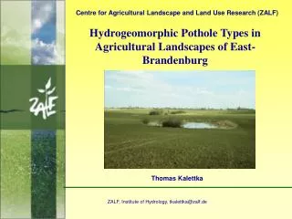
C entr e for Agr icultural Landscape and Land Use Research (ZALF). Water Quality of Potholes in Agricultural Landscapes of East-Brandenburg (Germany). Thomas Kalettka 1 & Catrin Rudat 2. 1 ZALF, Institute for Hydrology, tkalettka@zalf.de 2 Umweltplan Stralsund Gmbh, cr@umweltplan.de.

E N D
Centre for Agricultural Landscape and Land Use Research (ZALF) Water Quality of Potholes in Agricultural Landscapes of East-Brandenburg (Germany) Thomas Kalettka1 & Catrin Rudat2 1 ZALF, Institute for Hydrology, tkalettka@zalf.de 2 Umweltplan Stralsund Gmbh, cr@umweltplan.de
Dynamics of water quality parameters of potholes - Electric conductivity - Electrolyte poor potholes: B_BAP, E_20, E_19 Electrolyte rich potholes: E_6, B_205, L_17f
Water quality parameters of potholes - Electrolyte pollution - very softly 0-4°dH softly: 4-8°dH moderate hard: 8-12°dH fairly hard: 12-18°dH hard: 18-30°dH very hard: >30°dH
Dynamics of water quality parameters of potholes - bioproduction and matter dynamics - Polytrophic pothole B-BFA 1993-1998 Characteristics of potholes eutrophication : - summer period: dense hydrophyte stands with reduced species number - winter period: maximum of algae - cyclic reduced oxygen: internal matter loading from the sediment
Correlation between phytoplancton and macrophytes Macrophytes not dominant Macrophytes dominant
Analysis of bioavailability of phosphorus from sediments bioavailability a) direct available P SRP of the NH4Cl-extract of P b) reductive available P SRP of the BD-extract c) total available P sum SRP of the extracts d) not available P residual-P SRP = Soluble Reactive P NRP = Not Reactive P (NRP= TP-SRP) TP = Total P
Internaleutrophicationby release of phosphorus from sediments increasing of redox sensitive potential for P-release 1: B-BAP; 2: B-II/8; 3: B-KP; 4: E-19; 5: L-18b; 6: E-6; 7:E.20; 8: L-18; 9: B-BFA; 10: B-207c; 11: B-203 Redox soluble Fe(III) bound phosphorus in the sediment Classification of the eutrophication potential of aquatic pothole sediments
Hydrochemical main parameters of potholes in agricultural landscapes High, significant correlation (p < 0,05) at 9 from 16 Parameters PCA-Ordination plot of extracted variables in correlation to 39 potholes Extraction: Mean components; factorrotation: varimax; Results: Factorloadings of variables marked loadings 0,65 Group 1: P-rich Mineral-poor Group 2: P-poor Mineral-poor Group 3: P-rich Mineral-rich Group 4: P-poor Mineral-rich
Wasser quality (trophic level) of potholes in agricultural landscapes (modified method by Klapper 1992) Lietzen (n=15), Eggersdorf (n=15), Müncheberg incl. Eggersdorf (n=59) (2,5-2,9 = eutroph; 3,0-3,4 = high eutroph; 3,5-3,9 = polytroph; 4,0-4,4 = high polytroph) • low trophic level within arable land = low matter loading disposition • · big potholes with wide buffer strips (high buffer capacity) • · small potholes within small slightly rolling catchment (low soil erosion) • · lacking of input from drainages • · soil ramparts at the upper shore (high buffer capacity)
Correlation between trophic level and matter loading disposition of potholes Assessment of matter loding disposition (MLD) by score system: MLD = Total (matter loading factors) – Total (buffer capacity of pothole) n = 29; r = 0,79; significant p < 0,001
Water quality classification of potholes (modified after Klapper 1992) 1* - Sum coverage of macrophytes + filamentous green algae </= 50 % 2* - Coverage % of whole surface water area with litoral charakter (maximum of vegetation period), Trophic level indication by species combinations, use only if sum of coverage of macrophytes/filamentous green algae >/= 25 %
Trophic level indication of standing waters by hydrophytes (literature) N* = Ellenberg et al. (1991) I° = Melzer (1988)
Preliminary trophic level indikation of potholes by hydrophytes *Coverage in % of whole water area with litoral charakter (maximum May to September)
Correlation between matter loadings and biodiversity of macrophytes n = 32; r = 0,19; nicht significant n = 32; r = 0,38; significant p < 0,02 n = 32; r = 0,64; significant p < 0,001 n = 32; r =0,59; significant p < 0,001 Problem: Shortage of weak eutrophic reference sites in the agricultural landscape
Correlation between water qualityandsurface sediment pollution n = 22; r = 0,76; significant p < 0,001 n = 22; r = 0,54; significant p < 0,01 • Problems: • influence of soil erosion and wet-dry cycle on mud formation (silicate muds) • shortage of weak eutrophic reference sites in the agricultural landscape n = 22; r = 0,66; significant p < 0,005
Influence of runoff in winter period on trophic level of potholes in agricultural landscapes with middle to high matter loading disposition 1 = low runoff 3 = snowmelt, high runoff, frozen soil 2 = rain, high runoff, soil not frozen 4 = snow/rain, thawing soil, middle runoff