Download
1 / 25
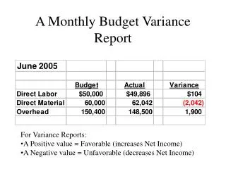
250 likes | 514 Vues
AERODROME WEATHER REPORT CODES (ACTUALS ) METARS. SAUK02 EGGY 231020Z METAR EGSS 231020Z 31015G30KT 1400SW 6000N R24L/P1500 SHRA FEW005 SCT010CB BKN025 10/03 Q0995 RETS WS RWY23 NOSIG 88290592=. BULLETIN HEADER. SA = METAR. UK02 = AREA CODE.

E N D
AERODROME WEATHER REPORT CODES (ACTUALS) METARS
SAUK02 EGGY 231020Z METAR EGSS 231020Z 31015G30KT 1400SW 6000N R24L/P1500 SHRA FEW005 SCT010CB BKN025 10/03 Q0995 RETS WS RWY23 NOSIG 88290592= BULLETIN HEADER SA = METAR UK02 = AREA CODE EGGY = Issuing authority, i.e. Bracknell 231020Z : Bulletin Date = 23rd/Bulletin Issue Time = 1020 Zulu or UTC. REPORT TYPE METAR - A/D Actual weather. Compiled half-hourly or hourly while station open SPECI - Aviation selected special weather report (SPECI will not be disseminated by either OPMET in UK or MOTNE in Europe) LOCATION INDICATOR ICAO four-letter code e.g. EGSS = Stansted
SAUK02 EGGY 231020Z METAR EGSS 231020Z 31015G30KT 1400SW 6000N R24L/P1500 SHRA FEW005 SCT010CB BKN025 10/03 Q0995 RETS WS RWY23 NOSIG 88290592= WIND • Direction in degrees True (3 digits) to nearest 10°. • Wind speed (2 digits), usually 10 minute mean. • Followed by Units. KT, KMH or MPS. E.g. 31015kt • Further 2 or 3 digits preceded by G gives gust speed when it exceeds 10 minute mean by 10 kt or more E.g. 31015G30KT • Calm indicted by 00000 followed by units. • Variable wind direction given by VRB followed by speed and units. • If direction varies by 60° or more during10 minutes preceding the observation, the observed extremes are given in clockwise order. E.g. 31015G30KT 280V350
SAUK02 EGGY 231020Z METAR EGSS 231020Z 31015G30KT 1400SW 6000N R24L/P1500 SHRA FEW005 SCT010CB BKN025 10/03 Q0995 RETS WS RWY23 NOSIG 88290592= HORIZONTAL VISIBILITY If no marked variation, the minimum given in metres. For marked visibility variation the reported minimum is followed by one of 8 points of the compass. E.g. 4000 NE If the minimum visibility is less than 1500m and the visibility in another direction is greater then 5000m then both are given. E.g. 1400SW 6000N Visibility of 10 km or more indicated by 9999 Visibility of less than 50 m indicated by 0000
SAUK02 EGGY 231020Z METAR EGSS 231020Z 31015G30KT 1400SW 6000N R24L/P1500 SHRA FEW005 SCT010CB BKN025 10/03 Q0995 RETS WS RWY23 NOSIG 88290592= RUNWAY VISUAL RANGE (RVR) RVR group always prefixed by letter R followed by runway designator, followed by diagonal followed by touchdown RVR in metres. Parallel runways indicated by letters L, R or C. E.g. R24L/1100 When RVR is greater than the maximum reportable value then RVR figure preceded by letter P. E.g. R24L/P1500 When the RVR is less than the minimum reportable value then the RVR figure preceded by the letter M. E.g. R24L/M0050 Until further notice trends and significant variations in RVR will not be reported in the U.K.
SAUK02 EGGY 231020Z METAR EGSS 231020Z 31015G30KT 1400SW 6000N R24L/P1500 SHRA FEW005 SCT010CB BKN025 10/03 Q0995 RETS WS RWY23 NOSIG 88290592= PRESENT WEATHER CODES BR, HZ, FU, IC, DU and SA will not be reported when the visibility is >5000m
SAUK02 EGGY 231020Z METAR EGSS 231020Z 31015G30KT 1400SW 6000N R24L/P1500 SHRA FEW005 SCT010CB BKN025 10/03 Q0995 RETS WS RWY23 NOSIG 88290592= CLOUD COVER Shown by 6 character group. First 3 indicate cloud amount in OKTAS. FEW = 1 to 2 oktas BKN = 5 to 7 oktas SCT = 3 to 4 oktas. OVC = 8 oktas Last 3 indicate height of cloud base above a/d level E.g: FEW018 = 1 to 2 oktas at 1800 feet above a/d level. Only significant convective cloud identified. CB = Cumulonimbus TCU = Towering Cumulus. E.g: SCT018CB Sky obscured = VV///
SAUK02 EGGY 231020Z METAR EGSS 231020Z 31015G30KT 1400SW 6000N R24L/P1500 SHRA FEW005 SCT010CB BKN025 10/03 Q0995 RETS WS RWY23 NOSIG 88290592= CLOUD COVER REPORTING SEQUENCE First group = Lowest layer of 1 okta or more Second group = Next layer of 3 oktas or more Third group = Next layer of 5 oktas or more. Additional group = Significant convective cloud if not already reported. Cloud groups given in ascending order of height. E.g: FEW005 SCT010 SCT018CB BKN025 If there is no cloud to report and CAVOK does not apply, then SKC (sky clear) reported
SAUK02 EGGY 231020Z METAR EGSS 231020Z 31015G30KT 1400SW 6000N R24L/P1500 SHRA FEW005 SCT010CB BKN025 10/03 Q0995 RETS WS RWY23 NOSIG 88290592= CAVOK Visibility, RVR, weather and cloud groups replaced by CAVOK when: Visibility is 10 km or more. No cloud below 5000 ft or MSA, whichever is greater, and No CB present No significant weather phenomena at or in vicinity of a/d.
SAUK02 EGGY 231020Z METAR EGSS 231020Z 31015G30KT 1400SW 6000N R24L/P1500 SHRA FEW005 SCT010CB BKN025 10/03 Q0995 RETS WS RWY23 NOSIG 88290592= AIR TEMPERATURE AND DEW POINT Given in degrees Celcius. Prefix M indicates negative value. E.g: 10/03; 01/M01; 00/M00.
SAUK02 EGGY 231020Z METAR EGSS 231020Z 31015G30KT 1400SW 6000N R24L/P1500 SHRA FEW005 SCT010CB BKN025 10/03 Q0995 RETS WS RWY23 NOSIG 88290592= ALTIMETER SETTING (QNH) QNH is rounded down to nearest whole millibar. Reported as 4 figure group preceded by letter Q E.g: Q0995 When reported in inches of mercury Prefixed by letter A followed by 4 figure group E.g: A3027 = 30.27 inches of mercury.
SAUK02 EGGY 231020Z METAR EGSS 231020Z 31015G30KT 1400SW 6000N R24L/P1500 SHRA FEW005 SCT010CB BKN025 10/03 Q0995 RETS WS RWY23 NOSIG 88290592= SUPPLEMENTARY INFORMATION Consists of one or more of the following groups in sequence: Recent weather. Windshear. Trend. Runway state group.
SAUK02 EGGY 231020Z METAR EGSS 231020Z 31015G30KT 1400SW 6000N R24L/P1500 SHRA FEW005 SCT010CB BKN025 10/03 Q0995 RETS WS RWY23 NOSIG 88290592= Recent weather. Operationally significant weather observed since last observation or during the past hour, whichever is shorter. Prefixed by letters RE followed by appropriate weather codes. E.g: RETS, REGR, RESHRA.
SAUK02 EGGY 231020Z METAR EGSS 231020Z 31015G30KT 1400SW 6000N R24L/P1500 SHRA FEW005 SCT010CB BKN025 10/03 Q0995 RETS WS RWY23 NOSIG 88290592= Windshear Inserted when windshear encountered along takeoff or approach paths below 1600 feet with reference to the runway. Prefixed by the letters WS. E.g: WS RWY20, WS ALL RWY. Until further notice, UK aerodromes will not insert windshear groups.
SAUK02 EGGY 231020Z METAR EGSS 231020Z 31015G30KT 1400SW 6000N R24L/P1500 SHRA FEW005 SCT010CB BKN025 10/03 Q0995 RETS WS RWY23 NOSIG 88290592= TREND This a forecast of significant changes in weather conditions during the two hours following the observation time. Change Indicators BECMG (becoming) TEMPO (temporary) followed by by a 4 figure time group (in hours and minutes UTC) preceded by one of the following, FM (from), TL(until) or AT (at). Weather Standard codes used. NOSIG used when no significant change in weather conditions expected. E.g: BECMG FM1100 25035G50KT; TEMPO FM0630 TL0830 3000 SHRA.
SAUK02 EGGY 231020Z METAR EGSS 231020Z 31015G30KT 1400SW 6000N R24L/P1500 SHRA FEW005 SCT010CB BKN025 10/03 Q0995 RETS WS RWY23 NOSIG 88290592= RUNWAY STATE GROUP See handout .
Letters FC = 9 hour TAF (Issued every 3 hrs.) FT = 18 hour TAF. (Issued every 6 hrs.) UK31 = Forecast region. EGGY = Issuing authority (Bracknell UK). Date of issue = 30th. Time of issue = 0900UTC. EGGW = ICAO location identifier. 301019 = Valid on date 30th between 1000 UTC and 1900 UTC. FCUK31 EGGY 300900 EGGW 300900 301019 23010KT 9999 SCT010 BECMG 1114 6000 -RA BKN 012 TEMPO 1418 2000 RADZ OVC004 FM1800 30020G30KT 9999 -SHRA BKN015CB= HEADER:
FCUK31 EGGY 300900 EGGW 300900 301019 23010KT 9999 SCT010 BECMG 1114 6000 -RA BKN 012 TEMPO 1418 2000 RADZ OVC004 FM1800 30020G30KT 9999 -SHRA BKN015CB= Forecast Elements of a TAF. Surface Wind Visibility Weather Cloud Probability Significant changes Amendments Other Groups (not used on UK civil aerodromes). Forecast temperature. Airframe ice accretion. Turbulence.
FCUK31 EGGY 300900 EGGW 300900 301019 23010KT 9999 SCT010 BECMG 1114 6000 -RA BKN 012 TEMPO 1418 2000 RADZ OVC004 FM1800 30020G30KT 9999 -SHRA BKN015CB= Surface Wind : Same format as METAR. Variations in direction not forecast. Horizontal Visibility : Same format as METAR. Only the minimum expected forecast. Weather: If no significant weather expected - group omitted. If the weather after a change group ceases to be significant - abbreviation NSW (no significant weather) inserted. Cloud : When clear sky forecast - SKC (sky clear) inserted or CAVOK if criteria apply. If SKC or CAVOK not appropriate then NSC (no significant cloud) used. Only CB cloud will be specified.
FCUK31 EGGY 300900 EGGW 300900 301019 23010KT 9999 SCT010 BECMG 1114 6000 -RA BKN 012 TEMPO 1418 2000 RADZ OVC004 FM1800 30020G30KT 9999 -SHRA BKN015CB= • Significant Changes : • BECMG • followed by 4 figure time group indicates expected permanent change in items specified at regular or irregular rate. E.g. BECMG 2124 27017KT 4000 BKN010 • FM • followed by 4 figure time group in hours and minutes UTC to indicate beginning of a self contained part of forecast. • All conditions before FM are superseded by conditions indicated after group.
FCUK31 EGGY 300900 EGGW 300900 301019 23010KT 9999 SCT010 BECMG 1114 6000 -RA BKN 012 TEMPO 1418 2000 RADZ OVC004 FM1800 30020G30KT 9999 -SHRA BKN015CB= • Significant Changes Cont.: • TEMPO • followed by 4 figure time group indictes temporary variations in f/cast wx. Each occurrence lasting <1hour and in total less than half period specified. • PROB • followed by 30 or 40 as a % followed by 4 figure time group. E.g. PROB40 TEMPO 1416 TSRA.
FCUK31 EGGY 300900 EGGW 300900 301019 23010KT 9999 SCT010 BECMG 1114 6000 -RA BKN 012 TEMPO 1418 2000 RADZ OVC004 FM1800 30020G30KT 9999 -SHRA BKN015CB= Amendments : AMD inserted after location identifier to indicate amended TAF. The new forecast covers remaining period of validity. E.g: TAF EGZZ AMD 130820Z 130816 In an amended TAF bulletin, the indicators AAA or AAB and time of origin will appear in the header line beginning FC or FT. AMD and date/time not normally used in UK TAF’s.
FCUK31 EGGY 300900 EGGW 300900 301019 23010KT 9999 SCT010 BECMG 1114 6000 -RA BKN 012 TEMPO 1418 2000 RADZ OVC004 FM1800 30020G30KT 9999 -SHRA BKN015CB= Other Groups: Forecast Temperature Airframe Ice Accretion Turbulence Not used at UK civil aerodromes, but are used in overseas and UK military TAF’s. See handout for decodes. Have not yet been asked in CAA exams.