Download
1 / 27
280 likes | 423 Vues
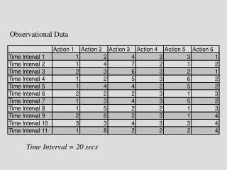
NDBC Presentation Observational Data Workshop September 14, 2011 Rex Hervey NWS/NDBC. National Data Buoy Center.

E N D
NDBC Presentation Observational Data Workshop September 14, 2011 Rex Hervey NWS/NDBC
National Data Buoy Center To provide a real-time, end-to-end capability beginning with the collection of marine atmospheric and oceanographic data and ending with its transmission, quality control and distribution. Tsunami Warning Centers NDBC & other NOAA observations IOOS Partners Platforms Weather Forecast Offices/River Forecast Centers NWS Telecommunication GatewayOperational Bulletins NDBC Data Assembly Center National Centers forEnvironmental Prediction Emergency Managers Oil & Gas Platforms National Environmental Satellite, Data, and Information Service (NCDC, NODC, NGDC) HF Radars Public DATA COLLECTION DATA DELIVERY
NWS/NDBC Ocean Observing Systems 110 met/ocean buoys 3 ocean/waves buoys 51 C-MAN stations 39 DART stations 55 TAO buoys + 4 current profiler moorings 800 + Voluntary Observing Ship vessels
Monitor status of all NDBC platforms – 24x7x365 Alert users and customers of actual or potential outages Monitor status of gliders within the Glider Operations Center Management of station configuration and metadata Automated and Manual Quality Control Procedures Combination of Physical Scientists and IT Specialists Ingest, process and analyze observations Conduct data processing and QC algorithm development Disseminate observations via multiple methods Mission Control Center
Proper Data Management • More than just placing a meteorological, oceanographic or geophysical instrument in the water or on the land, • More than just collecting an observation, and • More than just disseminating the data via a data portal NDBC’s Data Management will follow: • Global Climate Observing System’s Climate Ten Monitoring Principles: http://www.ncdc.noaa.gov/crn/crnclimmonprin.html • Quality Assurance of Real-Time Ocean Data’s Seven Data Management Laws: http://www.facebook.com/topic.php?uid=183720751655&topic=13660
Weather and Ocean (WxOP) Buoys 1.8-m discus, 3-m discus, 6-m boat-shaped NOMAD , 10-m/12-m discus buoys
Operations at NDBC and in the Field • System Preparation, Integration and Testing at NDBC • System/component and mooring fabrication • System/component refurbishment • System integration • System testing • Field Operations • System deployment • Field trouble-shooting and repair • Field refurbishment • System retrieval
Components of NDBC Observing Systems Communications Transmitters Antennas Position tracking devices Meteorological Sensors Wind speed/direction Air pressure Air temp Relative humility Power system Batteries Solar panels Controller Buoy/platform structures Buoy hull/platform Surface structures (e.g., Mast) Underwater structures Payload/data logger Ocean Sensors (surface/subsurface) Surface Current Surface temperature/salinity Current Profiler Temperature/salinity Profiler Directional & non-directional Wave Measurements Other ocean parameters Support equipments Radar reflector O&I light Other sensors Bottom Pressure Recorder Bottom-mount systems (e.g., current profiler) Mooring system Cables Floats Anchors
3 – Meter Discus Buoy • Most common • Anemometer at 5 – meters • Fin orients buoy into wind • Discus hull allows for measurement of directional waves • Hull now made at NDBC
6-Meter NOMAD Buoy • Can’t measure directional waves • Not axi-symettric • Bridled from port to starboard • Can take anything except excessive icing • Anemometer height is about 5-m. • Probably won’t acquire anymore
Large navigation buoys (LNBs) Anemometer height at 10 meters Can capsize in steep seas with H0 > 10 m Must be towed, others can be lifted and trucked Steel hull is difficult to maintain Being phased out 10/12-m Discus Buoys
Did I mention they can flip? • Last report from 42073 04/07/2011 @ 1550 • Wind dir =250 • Wind speed = 24 m/s • Gust = 30 m/s • Wave height = 11.7 m • Peak period = 16 s • Average period = 11.2 s
C-MAN Stations • Anemometer heights vary. Many are 20 - 40 m. • Power available. Easier to install additional sensors • Low maintenance costs, but access is becoming more difficult as Coast Guard turns over property to other organizations.
Climate Monitoring Platforms Tropical Atmosphere Ocean (TAO) 55 equatorial Pacific buoys 4 Ocean Current Profilers ~250 Ship days at sea on NOAA vessels
Tsunami Monitoring Platforms Deep-ocean Assessment and Reporting of Tsunamis 39 Stations ~230 ship days at sea on charter vessels
New Developments • Insertion of Benthic Glider Data from Partner Organizations to GTS, also AXBTs, hurricane profiling floats • Acquiring and disseminating Marine Arctic Data (wx buoys, ice tethered profilers) • Wave Glider Testing as a WX and Tsunameter Platform • 2.3 – Meter Standard Buoy
2.3-Meter Standard Hull • One hull for WxB, TAO and DART fleets • More economical foam hull • Easier to transport • Easier to deploy • Greater standardization • 4-meter anemometer ht.
Standard Buoy Development Multi-purpose / Multi-configurable Platform TAO WEATHER DART
Wave Glider Launched by NDBC South of Pascagoula, MS April13, 2011 On station 5 nm SSW of 10-m buoy 42040 in the Gulf of Mexico until June 11, 2011
Wave Gliders – How they Work 5 meters 1 meter • Wave Glider is comprised of a surfboard-like float with a ~ 20 ft rubber tether • connected to a submerged frame supporting multiple free-swiveling wings • Up/down motion on wings due to wave action produces forward propulsion
Wave Glider Discussion • Wave gliders can potentially replace weather buoys at selected stations if they can collect data that meets NOAA/NWS requirements. • If they can meet accuracy requirements, they may reduce the reliance on available Coast Guard ship time since they can be deployed and retrieved by small boats close to shore. • Wave Gliders, in some cases, could be deployed and repositioned without requiring fielding of maintenance teams or larger vessel support. • NDBC is just beginning to evaluate the potential of wave gliders as meteorological stations. Much more work is required to determine what the quality of the data will be under a variety of conditions.
Contact: Rex HerveyMeteorologistNOAA/NWS/NDBCStennis Space Center, MSOffice: 228 688-3007Email: rex.hervey@noaa.gov