Download
1 / 29
290 likes | 420 Vues
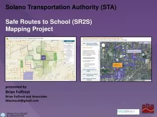
Solano Transportation Authority (STA) Safe Routes to School (SR2S) Mapping Project presented by Brian Fulfrost Brian Fulfrost and Associates bfaconsult@gmail.com. Project Goals.

E N D
Solano Transportation Authority (STA) Safe Routes to School (SR2S) Mapping Project presented by Brian Fulfrost Brian Fulfrost and Associates bfaconsult@gmail.com
Project Goals Goal 1: Make “suggested routes to school” Maps (to promote walking) for ~85 public schools as part of the Solano County's SR2S program • Method: Utilize network analysis tools in GIS to automate the creation of suggested routes and maps Goal 2: Provide web mapping tool for public outreach to obtain input on suggested routes, features of walking routes (e.g. sidewalk conditions, traffic control, etc.) as well as interactive access to suggested routes and maps Method: Develop web mapping application using Google API
Mapping Steps • Determine Criteria for creating suggested routes • Create Sidewalk Network (blocks and crosswalks) • Generate Walksheds around schools • Data Collection of criteria (block by block) • Generate Suggested Routes using Network Analyst • Manually Edit Routes (where necessary) • Generate Map Book of Final Suggested Routes to School
Step 1: Mapping Criteria • Sidewalks • 1. Type of Sidewalk(detached, attached, enhanced, none) • 2. Sidewalk Buffer(green strip, on-street parking, both, none) • 3. Number of Travel Lanes • Modifiers • Sidewalk Condition • Street Type • Median • Commerical Curb-Cuts • Obstructions • Alleyway • Crosswalks • 1. Crosswalk Type (enhanced and marked, marked, not marked, barrier/prohibited) • 2. Traffic Control Devices (signal, all-way stop, side street stop, uncontrolled) • 3. Curb Ramps • Modifiers • Crossing Guards • Number of Travel Lanes • Median
Step 2: Create Sidewalk Network • (a) Copy Parallel Street Centerline • (b) Topologically Clean Result • (c) Manual Edits (where necessary)
Step 3: Generate Walksheds using Network Analyst to identify data collectionandwalking area for maps • (a) Digitize school “access points” as starting point for walksheds • (b) Generate 10 and 20 minute “walksheds” along street network using Service Area function • (c) Clip Walksheds to Enrollment Boundaries
Step 4: Data Collection Criteria for Sidewalks and Crosswalks are collected block by block within 10/20 minute walksheds, in a number of ways: 1. GPS Field Audits 2. Virtual Audits • Trimble Yuma with ProXT antenna (sub-meter) • Terrasync Field Data Collection Forms • High resolution Aerial Photos • Google Streetview
Step 4: Data Collection Virtual Audits
Step 4: Data Collection 3. Walk Audits (around 14 schools) – conducted by Alta
Step 4: Data Collection 5. QA/QC of Data Collection
Step 5: Generate Suggested Routes using Network Analyst • 1. Digitize points as origin location(s)for suggested routes • enrollment density • walk audits 2. Use school “access points” as destination location(s)for suggested routes 3. Calculated Suitability Score of each sidewalk and crosswalk using lookup table of weighted numeric values for each of the criteria (e.g. sidewalk type) • Suitability Cost = 100 – Suitability Score • Sidewalk suitability cost then scaled between 1-10 (weights distance more) • Crosswalks suitability cost scaled between 1-20 (weights crosswalks more) 4. UseClosest Facility Analysis tool in Network Analyst to generate routes between origin and destination points. • Impedance Cost = X distance (in feet) • Global Turn Cost (to improve directness) • Barriers (prohibited crossings or crossing arterials without crosswalk)
Step 5: Generate Suggested Routes using Network Analyst • Suitability Score Example
Step 1: Mapping Criteria • Sidewalks • 1. Type of Sidewalk(detached, attached, enhanced, none) • 2. Sidewalk Buffer(green strip, on-street parking, both, none) • 3. Number of Travel Lanes • Modifiers • Sidewalk Condition • Street Type • Median • Commerical Curb-Cuts • Obstructions • Alleyway • Crosswalks • 1. Crosswalk Type (enhanced and marked, marked, not marked, barrier/prohibited) • 2. Traffic Control Devices (signal, all-way stop, side street stop, uncontrolled) • 3. Curb Ramps • Modifiers • Crossing Guards • Number of Travel Lanes • Median
Step 5: Generate Suggested Routes using Network Analyst • Routing Solution Example
Step 6: Manually Edit Routes (where necessary) • Based on: • (a) walk audits • (b) review by Alta • (c) review by Sr2S Advisory Committees
Step 7: Generate Map Book of Final Suggested Routes to School • 1. Cartographic design by BFA, Finger Design and Alta • Recommended Routes serve as “suggested walking arterials” • Suitability scores not shown – but suitability of a given side of the street is indicated by: • Presence of Sidewalks displayed as “good walking route” • Presence of Marked Crosswalk also displayed • Presence of Traffic signals and 4-way stops displayed • Absence of sidewalks are displayed and “to be avoided” • Park/Walk Locations added to final maps 2. Map Book for all 85 schools automated using Data Driven Pages in ArcGIS
Step 7: Generate Map Book of Final Suggested Routes to School
Step 7: Generate Map Book of Final Suggested Routes to School
Web Mapping Tool (Public Outreach) • 1. The Solano County Safe Routes Google Map Tool allows users to: • Find Suggested Routes to School (and Park/Walk locations) • Download the PDF of each schools Suggested Routes to School Map • Draw a route to school • Provide comments on walking route features (e.g. sidewalks, intersections, etc.) • Display Walking School Bus Routes and Meetup Locations • Edit Walking School Bus Routes and Meetup Locations (staff only) 2. Technologies: Google API, Javascript, JSON, Google Fusion, PHP http://solanosr2s.ca.gov/app_pages/view/10
Solano Transportation Authority (STA) Safe Routes to School (SR2S) Mapping Project Questions? Brian Fulfrost Brian Fulfrost and Associates bfaconsult@gmail.com 831-566-7686