Download
1 / 42
420 likes | 523 Vues
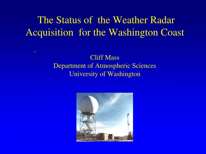
The Status of the Weather Radar Acquisition for the Washington Coast Cliff Mass Department of Atmospheric Sciences University of Washington. During the early 90s, the NWS installed a network of powerful Doppler Weather radars, aka NEXRAD WSR88D. NWS Radar Sites.

E N D
The Status of the Weather Radar Acquisition for the Washington CoastCliff Mass Department of Atmospheric SciencesUniversity of Washington
During the early 90s, the NWS installed a network of powerful Doppler Weather radars, aka NEXRAD WSR88D
But there was a major problem in the Pacific Northwest... The two NW radars (Camano Island, WA and Portland, OR) were placed east of the Olympics and Coastal Mountains and thus the radar beams were generally blocked before they reached the coast.
Radar coverage for the lowest beam (.5 degree elevation angle) for the current network. Red areas indicate no coverage below 8000 m (25,000 ft). Radar coverage calculations by Ken Westrick
The right diagram indicates the effective coverage of the Weather Service radars for all elevation angles at 10,000 ft above mean sea level, with hatching indicating substantial blockage.
Northwest Coastal Radar Problem • The Pacific Northwest has the worst coastal radar coverage of any region of the lower 48-states. • There is virtually no radar coverage for the lower atmosphere over the coastal zone and the near-shore waters. • Such poor coverage exists for a region of often intense storms AND a great deal of military, shipping, fishing and other marine traffic.
Coverage for Lowest Elevation Angle (.5 degrees) Now With Two New Radars
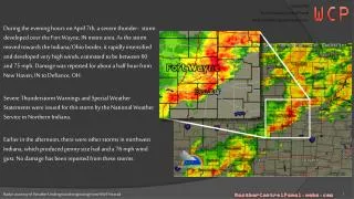
We Got A Taste of the Value of a Coastal Weather Radar During the IMPROVE Field Program in January-February 2001
dBZ Reflectivity from S-Pol radar at Westport 0031 UTC 2 Feb 2001 at 0.5 degree elevation
Years in the Wilderness • For roughly ten years a number of local meteorologists called for the acquisition of additional coastal weather radars, with one positioned on the central Washington Coast. • This went nowhere until three things happened in 2007 and 2008.
Dec. 2-3, 200720 inches in two days over coastal terrain of SW Washington Pictures courtesy of WSDOT The results: massive landslides and river flooding
Second: Growing Support for the Coastal Radar • Northwest Weather Modeling Consortium • Friends of Gray’s Harbor • Crab Industry, Fishers, and Oystermen • Audubon Society • Port Blakely Tree Farms • Cities and Counties • Puget Sound Clean Air Agency • Editorials in major local papers
Senator Cantwell Not Only Appreciated the Importance of a Coastal Radar But Secured the Funding • 2 million dollars of stimulus funding • 7 million dollars in the 2009-2010 budget
Current Status • The National Weather Service is now committed to installing and operating the radar. • It will be a powerful S-band (10-cm wavelength) Doppler radar like the current NEXRAD units. • It will be a be a dual-polarized radar, which the current radars are not. • (Dual-pol radars allow determination of precipitation type and better estimates of intensity.)
Where will the radar be located? • Using stimulus funds, the National Weather Service hired SRI International to do a site survey. • The University of Washington (Socorro Medina) did an independent analysis and provided it to SRI. • A draft siting report is out with possible locations, with one recommended. It will be released in March.
Some hints! • The sites are in Gray’s Harbor County, within 10 miles of the coast.
Beam blockage at 0.0° elevation angle for different radar locations(using ~1 km resolution terrain and a 30 m tower) N. Central Park - Site 6 Langley Hill – Site 12 ScarHill – Site 19 SaddleHill – Site 23
Beam blockage at 0.5° elevation angle for different radar locations(using ~1 km resolution terrain and a 30 m tower) N. Central Park - Site 6 Langley Hill – Site 12 ScarHill – Site 19 SaddleHill – Site 23
Beam blockage at 1.0° elevation angle for different radar locations(using ~1 km resolution terrain and a 30 m tower) N. Central Park - Site 6 Langley Hill – Site 12 ScarHill – Site 19 SaddleHill – Site 23
Beam blockage at 1.5° elevation angle for different radar locations(using ~1 km resolution terrain and a 30 m tower) N. Central Park - Site 6 Langley Hill – Site 12 ScarHill – Site 19 SaddleHill – Site 23
Beam blockage at 2.0° elevation angle for different radar locations(using ~1 km resolution terrain and a 30 m tower) N. Central Park - Site 6 Langley Hill – Site 12 ScarHill – Site 19 SaddleHill – Site 23
Radar Siting • There will be a one-month public comment period, with public notices, after the SRI report is released sometime this month. • With the community’s input, the land can be leased or purchased, and site preparation can begin.
Next Step: Acquisition of the radar • First, the radar specifications must be determined. • Then, bids must be acquired, followed by purchase. • There is some issues right now about the specs– zero degree scans and RHIs.
The Issues • Zero degree scans can allow you to see considerably further and get more information at low levels. • Range-Height Indicator (RHI) scans allow one to get details on the height of the freezing level, mountain precipitation, and offshore structures.
Distance-Height Diagram for Zero Degree and Standard 88-D Elevation Angles No coverage at .5 degree Note the absence of low-level coverage of the standard .5 degree elevation angle at greater distances (more than 100 km out). The zero degree angle provides a major improvement in coverage at long ranges in the critical lower atmosphere.
Examples of RHIs Example from IMPROVE 1: SPOL at Westport looking to the W Example from IMPROVE 1: SPOL at Westport looking to the E
Zero Degree and RHI • Local NWS offices, NWS Western region, and UW want it, Oklahoma radar folks are hesitant.
What do Oklahoma folks know about marine and mountain weather?
Timetable • Current NWS plans is for the radar to be installed in late 2012 and operational on January 1, 2013 • Looking at the specific timetable, this seems highly conservative. • Hopefully, the unit can be operational far earlier.