Political Geography Notes
Political Geography Notes. Chapter 8. Key Issue 1 – Where are states located?. Problems Defining States Not the Fifty Nifty… Says who? Development of the state concept Relatively recent – last few hundred years Many new states, almost 200 now. State. Area organized into a political unit

Political Geography Notes
E N D
Presentation Transcript
Political Geography Notes Chapter 8
Key Issue 1 – Where are states located? • Problems Defining States • Not the Fifty Nifty… • Says who? • Development of the state concept • Relatively recent – last few hundred years • Many new states, almost 200 now
State • Area organized into a political unit • Ruled by an established government • Government has control over internal and foreign affairs (sovereignty) • Occupies a territory • Permanent population • Commonly referred to as a “country”
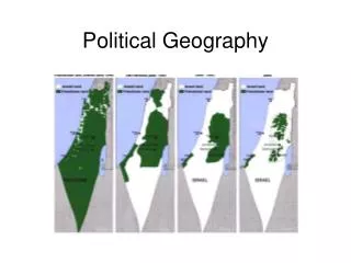
Korea: One State or Two? • Post WWII – north/south division along the 38th Parallel (38 degrees North)
US-Soviet involvement • US supported the South • USSR supported the North • Korean War • Part of Cold War • 1950-1953 • current cease fire
Other Examples • China and Taiwan • Western Sahara (Sahrawi Republic)
Development of “states” • Prior to 1800: • City-states • Empires • Tribes • Unorganized territory
Ancient and Medieval States • Ancient States • 1st states in Mesopotamia were city-states. This led to empires. • Early European States • Roman Empire • Feudalism • Consolidation and nationalism
European expansion • Colonialism • God, Gold, and Glory • When did colonialism begin? • 1492 • Imperialism • Control of land already occupied • UK had largest colonial empire
Post-Colonialism • Domino effect of independence movements • Many new states are formed
Key Issue 2 – Why do boundaries cause problems? • Shapes of States • Types of Boundaries • Boundaries inside states • Boundaries are formed by cultural and/or natural physical features. Latitude/longitude are often used as well.
Shapes of States • Compact – little variance in distance from center to any boundary • Makes communication & interaction easier • Examples: Burundi, Kenya, Switzerland, many others
Prorupted States • An otherwise compact state with a large projecting extension • Can provide access to a resource • Can disrupt other states
Elongated States • Long and narrow shape • Can lead to isolation or hinder communication and interaction • Example: Chile
Fragmented State • Contains several discontinuous pieces of territory • Can be caused by water or other states • Ex: Indonesia, Philippines, Russia
Perforated States • Completely surrounds another state • Diplomacy is crucial • Ex: South Africa (perforated) and Lesotho(compact)
Historically, frontiers separated states Only current regions separated by frontiers are in the Arabian Peninsula and Antarctica Types of Boundaries
Mountains Deserts Water Physical Boundaries
Geometric Lat./Long. lines Religious Ex: India, Pakistan, and Bangladesh Language Especially important in Europe, after WWI Cultural Boundaries
The Himalayan mountain range with Mount Everest as seen from the International Space Station looking south-south-east over the Tibetan Plateau. Four of the world's fourteen eight-thousanders, mountains higher than 8000 meters, can be seen. The South Col Route is Mount Everest's most often used climbing route.
Unitary – most or all power is held by the central government Works best in a nation-state Can be used to enforce values of one nationality on minority groups Ex: UK, Kenya, China, and many more Boundaries Inside States
Federal System • Power is shared by the national and local governments • More suitable for large and/or multinational states • Ex: United States, Canada, Russia, Brazil
Gerrymandering • Redrawing legislative boundaries to benefit a political party • Wasted, Excess, Stacked
Look over… • UN • NATO • Warsaw Pact • EU