GPR Survey Analysis of Camp Lawton's Southwest Corner by LAMAR Institute (Dec 2009)
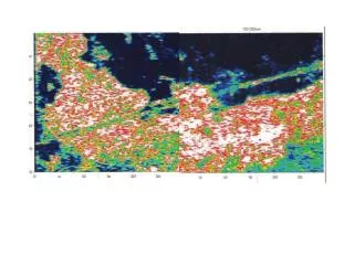
This report presents findings from a Ground Penetrating Radar (GPR) survey conducted by the LAMAR Institute at the southwest corner of Camp Lawton in December 2009. Utilizing UTM coordinates in NAD27, Zone 17, the analysis covers two points: A (E410183, N3637535) and B (E410288, N3637558). The survey focuses on the stockade, positioned in a red grid pattern, and oriented approximately 340 degrees, which is 20 degrees west of magnetic north. This investigation aims to enhance the understanding of the site's historical layout.

GPR Survey Analysis of Camp Lawton's Southwest Corner by LAMAR Institute (Dec 2009)
E N D
Presentation Transcript
Tentative Definition of Southwest Corner, Camp Lawton, LAMAR Institute GPR Survey, December 2009 A UTM NAD27, Zone 17: A--E410183, N3637535 B--E410288, N3637558 B GN MN 0 25m 50 Stockade in Red Grid North is 340 degrees (20 degrees West of MN)