
Weather Forecasting Terms
Decode meteorological abbreviations like ACSL, BWER, CASCDS, and more with this comprehensive guide on weather forecasting terminology.

Weather Forecasting Terms
E N D
Presentation Transcript
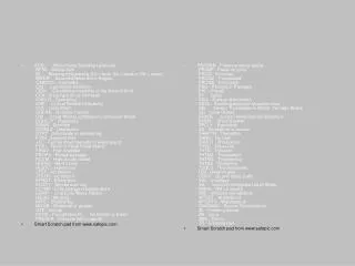
ACSL - Altocumulus Standing Lenticular BFDK - Before dark BL... - Blowing (followed by DU = dust, SA = sand or SN = snow) BWER - Bounded Weak Echo Region CASCDS - Cascades CIN - Convective Inhibition CISK - Conditional Instability of the Second Kind. CLA - Clear type of ice formation CNCLG - Cancelling CRP - Critical Rainfall Probability CUF - Cumuliform CUFRA - Cumulus Fractus CW - Cloud-Water Lightning or Continuous Wave DGNLLY - Diagonally DMSH - Diminish DSTBLZ - Destabilize DTRT - Deteriorate or deterioring ETIM - Elapsed time +FC - Funnel cloud (tornado or waterspout) FFA - Flood or Flash Flood Watch FIRAV - First available FROPA - Frontal passage HCVIS - High clouds visible HDFRZ - Hard freeze HLSTO - Hailstones JTST - Jet stream JTSTR - Jet stream KFRST - Killing frost KOCTY - Smoke over city LCTMP - Little change in temperature LEWP - Line Echo Wave Pattern MEGG - Merging MIFG - Shallow fog MOGR - Moderate or greater OTP - On top PCPN - Precipitation PL - Ice Pellets or Sleet PRESFR - Pressure falling rapidly Smart Scratch pad from www.safepic.com PRESRR - Pressure rising rapidly PRJMP - Pressure jump PROG - Forecast PROGD - Forecasted PROGS - Forecasts PSG - Passing or Passage PVL - Prevail PY - Spray SAO - Surface observation SCSL - Standing lenticular stratocumulus SEL - Severe Thunderstorm Watch, Tornado Watch SG - Snow Grains SHARS - Subtle Heavy Rainfall Signature SHSN - Snow Shower SPCLY - Especially SS - Sandstorm or sunset THRFTR - Thereafter THRU - Through THRUT - Throughout THSD - Thousand THTN - Threaten THTND - Threatened THTNG - Threatening THTNS - Threatens TSQLS - Thundersqualls U/S - Unservicable UDDF - Up and down drafts VAL - In valleys VIL - Vertically Integrated Liquid Water WIBIS - Will be issued WIE - effective immediately WTSPT - Waterspout WTSPTS - Waterspouts WWAMKC - Severe Thunderstorm ZL - Freezing drizzle ZN - Zone ZNS - Zones ZR - Freezing rain Smart Scratch pad from www.safepic.com
ACSL - Altocumulus Standing Lenticular BFDK - Before dark BL... - Blowing (followed by DU = dust, SA = sand or SN = snow) BWER - Bounded Weak Echo Region CASCDS - Cascades CIN - Convective Inhibition CISK - Conditional Instability of the Second Kind. CLA - Clear type of ice formation CNCLG - Cancelling CRP - Critical Rainfall Probability CUF - Cumuliform CUFRA - Cumulus Fractus CW - Cloud-Water Lightning or Continuous Wave DGNLLY - Diagonally DMSH - Diminish DSTBLZ - Destabilize DTRT - Deteriorate or deterioring ETIM - Elapsed time +FC - Funnel cloud (tornado or waterspout) FFA - Flood or Flash Flood Watch FIRAV - First available FROPA - Frontal passage HCVIS - High clouds visible HDFRZ - Hard freeze HLSTO - Hailstones JTST - Jet stream JTSTR - Jet stream KFRST - Killing frost KOCTY - Smoke over city LCTMP - Little change in temperature LEWP - Line Echo Wave Pattern MEGG - Merging MIFG - Shallow fog MOGR - Moderate or greater OTP - On top PCPN - Precipitation PL - Ice Pellets or Sleet PRESFR - Pressure falling rapidly Smart Scratch pad from www.safepic.com PRESRR - Pressure rising rapidly PRJMP - Pressure jump PROG - Forecast PROGD - Forecasted PROGS - Forecasts PSG - Passing or Passage PVL - Prevail PY - Spray SAO - Surface observation SCSL - Standing lenticular stratocumulus SEL - Severe Thunderstorm Watch, Tornado Watch SG - Snow Grains SHARS - Subtle Heavy Rainfall Signature SHSN - Snow Shower SPCLY - Especially SS - Sandstorm or sunset THRFTR - Thereafter THRU - Through THRUT - Throughout THSD - Thousand THTN - Threaten THTND - Threatened THTNG - Threatening THTNS - Threatens TSQLS - Thundersqualls U/S - Unservicable UDDF - Up and down drafts VAL - In valleys VIL - Vertically Integrated Liquid Water WIBIS - Will be issued WIE - effective immediately WTSPT - Waterspout WTSPTS - Waterspouts WWAMKC - Severe Thunderstorm ZL - Freezing drizzle ZN - Zone ZNS - Zones ZR - Freezing rain Smart Scratch pad from www.safepic.com