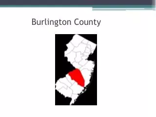
FLOOD STUDY Burlington County, NJ
150 likes | 300 Vues
FLOOD STUDY Burlington County, NJ. FEMA REGION II November 29, 2010. Agenda . Introductions and Roll Call Objectives Map Modernization (MapMod) Program Overview Burlington County MapMod Update Risk Mapping, Assessment, and Planning (Risk MAP) Program Overview Milestones.

FLOOD STUDY Burlington County, NJ
E N D
Presentation Transcript
FLOOD STUDYBurlington County, NJ FEMA REGION II November 29, 2010
Agenda • Introductions and Roll Call • Objectives • Map Modernization (MapMod) Program Overview • Burlington County MapMod Update • Risk Mapping, Assessment, and Planning (Risk MAP) Program Overview • Milestones
Introductions and Roll Call • FEMA Region II Project Manager: Paul K. Weberg, PE Communications / Outreach Support: Adie Koby Senior Engineer: Alan Springett Floodplain Management and Insurance Lead: Pat Griggs RSC Deputy Coordinator: TolgaYilmaz, CFM, GISP • State – New Jersey Department of Environmental Protection (NJDEP) Supervising Engineer: Joseph Ruggeri, PE, CFM Supervising Engineer: John Scordato Technical Assistance: A. Chris Gould, CFM • Mapping Partner - T.Y.Lin / Medina Project Manager: John Chayko, PE, CFM • Local - Burlington County & Communities
Objectives • Objectives • To provide an overview of Burlington County’s flood hazard mapping project status • To introduce new Risk MAP program • To promote community engagement and enhance capability to effectively manage flood risk
Map Modernization (MapMod) Program Overview • Prior to 2003, more than 70 percent of the nation’s flood maps were at least 10 years old. In Burlington County, with few exceptions, the communities' flood maps dated back to the 1980s • Congress appropriated funds in 2003 and directed FEMA to develop and implement the MapMod program, which: • Created county-wide digital maps • Utilized more current data to update maps • Developed a new platform to convert from paper to digital format
Burlington County MapMod Update • Original scope of Burlington County study • County-wide DFIRM (188 panels), including 40 incorporated communities • New detailed studies for 48.2 stream miles • Re-delineation/re-use of 282.7 miles of detailed studies • Re-delineation: Previously identified floodplains and associated detailed flood elevations paired with updated topographic data that retains the integrity of the existing Engineering analysis • Digital lift-up of 847 approximate stream miles • Digital lift-up: Using the floodplain boundary from the old effective maps as-is, without using the updated aerial or the updated topographic data • Incorporation of NJFHA boundary to the DFIRM maps and Flood Insurance Report (FIS) profiles • The DFIRM and FIS report will be produced in the FEMA Countywide format in the North American Vertical Datum of 1988 (NAVD88) • NAVD 88 = NGVD 29 – 1.2 • Preliminary DFIRM delivery scheduled for November 30, 2010 • Adjusted scope of Burlington County study • Post-preliminary process will be postponed until new LIDAR is collected
Risk MAP Program Overview • Risk Mapping, Assessment, and Planning (Risk MAP) is a new FEMA program that provides communities with flood information and tools they can use to enhance their mitigation plans and better protect their citizens • The Risk MAP program aims to achieve these goals through new and updated strategies and products that address: • Elevation data acquisition • Watershed study approach • Engineering and mapping • Risk assessment, mitigation planning support • Risk communications
Burlington County Elevation Data Acquisition Burlington County LIDAR will be collected in 2011
Milestones • Fall 2006: Burlington County-wide Flood Insurance Study/Flood Insurance Rate Maps funded • Spring, 2010: Available topographic data discussion with the Burlington County communities • Fall, 2010: Preliminary Burlington County Flood Maps delivered • End of January, 2011: Community review and comment • Planned for 2011: LIDAR acquisition for Burlington County
Resources • FEMA: www.fema.gov • Floodsmart, the official site of the National Flood Insurance Program (NFIP): www.floodsmart.gov • Risk Assessment, Mapping and Planning Partners: www.RAMPP-team.com • NFIP Reform: www.fema.gov/business/nfip/nfip_reform.shtm • New Jersey Department of Environmental Protection - NFIP Coordinator • New Jersey State Office of Emergency Management
Questions & Feedback • www.RAMPP-TEAM.com: PowerPoint Presentation & additional information will be posted Contact Information • FEMA Region II Paul Weberg, Pat Griggs, 212-680-3638 212-680-8523 Paul.weberg@dhs.govpatricia.griggs@dhs.gov • NJDEP John Scordato / Joseph Ruggeri / Chris Gould NJDEP, Bureau of Dam Safety & Flood Control Phone: 609-292-2296 Fax: 609-984-1908 Visit NJDEP website: www.nj.gov/dep/floodcontrol Download Model Ordinances: http://www.nj.gov/dep/floodcontrol/modelord.htm