L1 - Spatial Concepts
320 likes | 349 Vues
Learn about spatial queries and the different methods of storing geographic data in GIS, including set-based, topological, and graph-based data. Discover how to answer spatial queries without relying solely on coordinates.

L1 - Spatial Concepts
E N D
Presentation Transcript
L1 - Spatial Concepts NGEN06 & TEK230: Algorithms in Geographical Information Systems by: Irene Rangel, updated 2015-11-02 by Sadegh Jamali
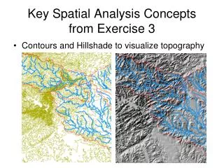
Concept of Space Object model –> set of objects (vector) Field-based model -> set of locations with properties (raster or grid) How do we store geographic data (geometry)?
Aim • Understand the relationship between spatial queries and mathematical concepts. • Know how topological relationships are defined in GIS. • Get knowledge about the relationship between type of queries and suitable methods of storing geographic data.
Content • Spatial queries • Set-based queries • Topological queries • Graph-based queries • Euclidean queries • Storing relationships or deriving in real-time?
Spatial Queries Set-based query: Is Uganda a country in Africa? Africa
Spatial Queries Topological queries Which countries are neighbours to Uganda? Africa Topological Relationships
Spatial Queries Graph-based queries How long is the traveling distance from Uganda to Egypt? Africa Relationships between elements distance between elements
Spatial Queries Euclidean queries What is the area of Uganda?
We are not always relying on coordinates (or the Euclidean space) in GIS; by storing set-based, topological and graph-based data explicitly (without using coordinates) we can answer many spatial queries without considering coordinates. But how storing explicitly?
Set-based queries Countries_in_africa ={Egypt, Uganda, ...} Z={..., -2, -1, 0 1 2, ...} R= the real numbers R2 = R x R E= {x=(x1,x2) | x R2 , 0<x1<100, 0< x2<100 }
Set algebra Set Operations: Union Intersection Complement Logical Operators: OR AND NOT
Data structure to store set based data explicitely Is Uganda a country in Africa? Table: Countries_in_Africa
Topological queries Topology is derived from the Greek and means the science of position. Topological Space: A set and a number of subsets (which follow certain rules)
Topological Relationships? Using a rubber sheet (where all points, lines and areas are drawn), topological relationships are the properties that remain between the points, lines and areas for all possible kinds of deformation of the rubber sheet (except tearing). <- Rubber sheet transformation Examples: Point is inside a polygon Two lines intersect Not a topological relationship: an object is close to another (spatial relationship)
Topological transformation • There should be one-to-one correspondence between the elements in the original and transformed set (bijection). • Two points that are ”connected” in the original set should also be ”connected” in the transformed set.
4-intersection model It is defined using the boundary and the interior of objects.This terminology is defined for cells (2 dimensional, connected sets without holes - closed) in R2. A A A Not Connected Connected
4-intersection model Definitions of boundary and interiors of connected objects (A) in R2
Definitions of topological relationships (using the 4-intersection model) Ø = empty set ¬ Ø = not empty set
Definitions of topological relationships (using the 4-intersection model) AdisjointB AcontainsB AmeetsB A covers B A coveredBy B A overlaps B AinsideB AequalsB
Other models of topological relationships • 9-intersection model (DE-9IM) The 4-intersection model is actually not that suitable for expressing topological relationships between line and/or point objects. DE-9IM was proposed to be an international standard by the International Standard Organization –ISO19125-1. Defines topological relationships using interior, exterior and boundary of objects.
Data structures to store topological data explicitly Link-node structure:a data structure that consists of a set of data records (nodes) linked together and organized by references (links).
Graph-based queries • Also called network queries • They consider distances • Shortest (fastest) route is a typical example.
Graph-based queries Traveling time between airports. The points (A, B, ... , H) are airports (i.e. elements in the set airports). The edges denote that there are flight routes between the airports.
Graph-based and metric queries • In a graph-based query there is no restriction on the distances between the elements in the set. • Metric query is a sub-set of a graph-based query that set constraints on the distances-> they must obey the rules of a metric.
Metric query A metric (d) is a distance measure between two elements in a set. The metric has to obey the 3 following rules (where p,q, and r are elements in the set, d=metric): • d(p,q)>=0, d(p,q)=0 p=q • d(p,q)=d(q,p) (symmetry) • d(p,q)<=d(p,r)+d(r,q) (triangle inequality)
Metric query There are an infinite number of metrics. Two of the most common metrics (in R2) in GIS are: 1) Euclidean distance: 2) Manhattan distance:d(p,q)= |xp- xq| + |yp- yq|
Data structures to store graph-based data explicitly • Graphs can be stored as matrixes. • Sparse graphs are normally stored in adjacency list (Sedgewick, 2002 ).
Euclidean queries What is the distance between a building and a road? -> Require coordinates to be stored.
Storing relationships or deriving in real time? • In some cases the relationships can be derived from stored coordinate data. • Traveling distance (but not traveling time) Storing relationships explicitly: • Advantages: • It saves processing time • Could enhance the quality of the answer • Disadvantages: • It takes more space in memory • It entails redundancy (storing same information twice)
Storing relationships or deriving in real time? A few things you should consider before you decide what relationships should be stored explicitly: • What type of queries will the database serve? • How will the database be maintained? • Will the database be connected to other databases? • …