Ocean Temperatures & Ocean Salinity
381 likes | 960 Vues
Ocean Temperatures & Ocean Salinity. Describe a Pattern: 5 steps BHFAL it!!. B ig ideas H ighest and lowest F igures and places A nomalies L inks. H orizontal V ariations in sea surface temperature.

Ocean Temperatures & Ocean Salinity
E N D
Presentation Transcript
Describe a Pattern: 5 stepsBHFAL it!! • Big ideas • Highest and lowest • Figures and places • Anomalies • Links
Horizontal Variations in sea surface temperature Sea surface temperature is highest along the equator and decreases closer to the poles. The temperature decreases with latitude. Along the equator temperature is high at 27 degrees C whereas at the Poles it is low at around 5 degrees C. An anomaly is the South West coast of Africa which is colder at 15 degrees C than the surrounding ocean at 20 degrees C.
Vertical variations in sea temperatures Mixed Layer – Surface temperatures vary with latitude Thermocline– temperature changes rapidly with depth “transition layer” between surface and deep sea Deep Water – All oceans reach uniform temperature of 2 degrees in the deep sea
Diagrams to show the vertical variation of sea temperatures (Thermoclines). One of these diagrams is for the Bahamas, one of these is for Iceland and one of these is for France? Explain your answer
Horizontal Variation in sea surface salinity The salinity is highest in the tropics at 37 psu and decreases towards the poles. Lowest Sea surface salinity is 31 psu in the North Pacific. This is linked to the amount of sunlight at different latitudes. However, along the equator, sea surface salinity is lower for example 32 psu off the Pacific coast of Central America. Sea surface salinity is also high in the Mediterranean sea at 38 psu and the Atlantic coast of Brazil. This links to the location of major river mouths.
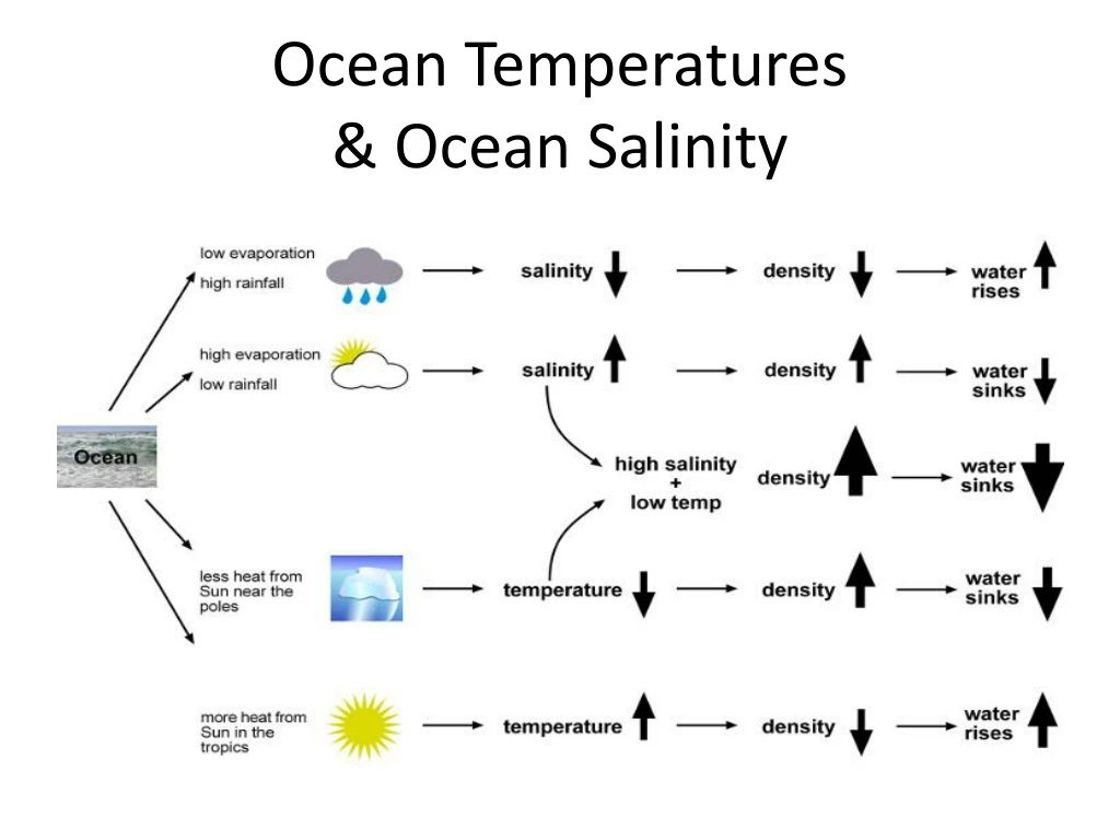
Why is any of this important!!!! Cold, saline and deep water is very dense. Warm, less saline and surface water is less dense When water masses meet, the less dense water goes over the more dense water. This causes the major deep ocean circulation that drives the climate of earth!
Impact on global scale- Regulates Earth’s ocean and atmospheric (climate) conditions(Why important for us??)Transfers heatand energy, nutrients and animals,between the Indian, Pacific and Atlantic ocean
Textbook pg. 136-8 • Explain two reasons for the variation of sea surface salinity? • How do ice bergs affect salinity? • What is the difference in salinity at depth between tropical and polar seas? • Which minerals form salt in sea water? • Why are temp and salinity important for density? • What is specific heat capacity and does it affect climate?
In your own words, describe the movement of the current in terms of ocean, movement, temperature and density. Colder (and salty) water sinks to about 4km at the south pole as it is dense It travels into the deep basins of the pacific and Indian ocean towards the equator where it warms and rises Warm surface water travels towards the North Atlantic Cold winds from Canada cause the ocean to loose its heat. Water starts to sink near North pole as it is colder. Atlantic is saltier than Pacific – its warmer so more evaporation and more salt (also denser so it sinks) 7. Eventually water is transported back to the Pacific where its cooler so less dense (helps deep currents rise)
IB Question:Explain the function of the oceanic conveyor belt(s). [6 marks] An overview of the OCB’s importance would be that it has a vital global role [1 mark] in regulating/moderating Earth’s ocean and atmospheric conditions [1 mark]. The remaining [4 marks] should be allocated for more detailed explanation either of the causes/functioning of OCB or a more detailed examination of its role in specific regions e.g. transferring heat/energy between the Pacific and Indian Oceans and the Atlantic Ocean. The North Atlantic is therefore warmer than the North Pacific, so there is likely to be more evaporation, condensation and precipitation there. There are other important regional effects too, notably cold counter-current returning to the equator, leading to localized cooling in equatorial waters. Some aspects of OCB are still not fully understood / science is contested, and good answers may reflect on this. Also accept wider interpretation of importance for human settlement and activities e.g. mild maritime climate of NW Europe.
Variations in salinity of oceans Average salinity is 35 parts per 1000 (ppt) Salt concentrations is higher in warmers seas due to higher evaporation rates. In polar seas, salinity is low as there is a lot of fresh water input from rivers. Minerals in sea water are Chloride (54.3%) and sodium (30.2 %) which combine to form salt. Other important minerals are magnesium and Sulphate ions In tropical seas salinity DESCREASES sharply with depth Salinity INCREASES with depth.
Variations in ocean temperatures Lots of variation at the surface little variation at depth • Tropical areas High sea surface temperatures (above 25°) are caused by insolation. (IN coming SOLarradiATION) Waves mix the water near the surface layer and distribute heat depending on wave strength and the existence of surface turbulence caused by currents. From 300-1000m The temperature declines steeply to about 10° • Polar ocean Surface temperatures between 0-5° Water doesn’t freeze at 0° because of salinity Shallow or non existent thermocline as water is uniformly cold • Mid latitudes Seasonal variations in surface temps. Winter 10°, Summer 17° More gradual decrease in thermocline.
Atmospheric Circulation • The Earth's atmosphere is put into motion because of the differential heating of the Earths surface. Which areas of Earth receive more heat? Why: 1. Sun's rays are more perpendicular to the Earth and the cross-sectional area of Sun's rays striking the earth's surface is smaller at the equator. Therefore, the heating per square area is greater at the equator than at the poles. 2. The thickness of the atmosphere that the Sun's rays must past through is greater at the poles than at the equator. Therefore, more of the radiation is lost at the poles than at the equator. Equator gets more heat than the poles
More atmosphere to get through More insolation here at the equator
At the Equator Atmosphere is heated Air becomes less dense and rises Rising air creates low pressure at the equator Air cools as it rises Water vapor condenses as the air cools with increasing altitude (rains) Creates high rainfall over equator As air mass cools it increases in density and descends back to the surface creating high pressure This circulation is called the Hadley Cell
If the earth didn’t rotate we would have one cell………. Air sinks at the Poles as it is cold and dense Air rises at equator – rain falls
Deflects the winds as they blow from high to low pressure. Corriolis force TEST!!!