Download
1 / 21
210 likes | 324 Vues
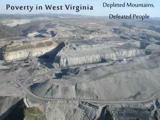
This study by Michael Shank from the West Virginia Department of Environmental Protection utilizes advanced digital elevation analysis to characterize surface mining in the region. It comprises three main components: estimating visibility using InSAR Digital Surface Models (DSM), detecting changes in Digital Elevation Models (DEM) to identify valley fills, and extracting mining highwalls from LiDAR data. The findings revealed over 1,300 valley fills and more than 150 miles of highwalls previously unaccounted for in existing inventories, significantly enhancing the understanding of mining impacts.

E N D
Digital Elevation Analysis to Characterize Surface Mining in West Virginia Michael Shank West Virginia Department of Environmental Protection
1. Visibility Estimation Using IFSAR DSM 2. DEM Change Detection to Identify Valley Fills 3. Extracting Mining Highwalls from LIDAR
Final fill inventory included over 1,300 valley fills, refuse fills, and slurry impoundments. The study identified over 500 fills that were not present in the DEP’s fill inventory compiled from available permit maps.
The analysis identified over 150 miles of highwalls not currently in the inventory, effectively doubling the current amount.